
Specifically, from August 7 to the end of the night of August 8, in the mountainous and midland areas of the North, there will be moderate rain, heavy rain, some places will have very heavy rain and scattered thunderstorms with common rainfall of 50-120mm, some places will have over 180mm; other areas in the North, Thanh Hoa and Nghe An will have showers and scattered thunderstorms, locally heavy rain with rainfall of 20-40mm/24h, some places will have over 70mm/24h.

Beware of flash floods, landslides in mountainous areas and flooding in low-lying areas. Beware of heavy rain in a short period of time causing flooding in urban areas. During thunderstorms, there is a possibility of tornadoes, lightning, and strong gusts of wind.
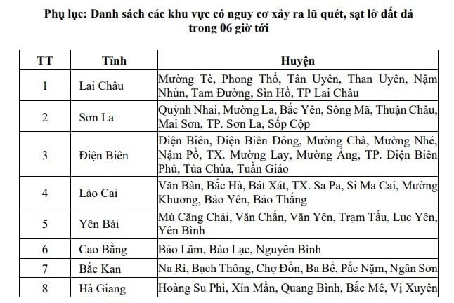
Accordingly, there is a high risk of flash floods on small rivers and streams, landslides on steep slopes in many districts in the mountainous areas of the North according to the following appendix:
In Dak Nong province, there is a high risk of flash floods on small rivers and streams, landslides on steep slopes, especially in the districts of Tuy Duc, Dak Song, Dak Glong, and Krong No.
FORECAST FOR STRONG WINDS, HIGH WAVES AND THROWS AT SEA
During the day and night of August 7, in the North and Central East Sea (including the waters of Hoang Sa archipelago), Bac Bo Gulf, and the waters from Khanh Hoa to Binh Thuan, there will be strong southwest winds of level 5, sometimes level 6, gusting to level 7-8; rough seas; waves 2.0-3.5m high, especially in the South of Bac Bo Gulf, waves will be 1.5-2.5m high.
In addition, during the day and night of August 7, there will be scattered showers and thunderstorms in the northern part of the Gulf of Tonkin. There is a possibility of tornadoes and strong gusts of wind during thunderstorms.
Warning: During the day and night of August 8, in the Central East Sea, the Gulf of Tonkin and the sea from Khanh Hoa to Binh Thuan, there will be strong southwest winds of level 5, sometimes level 6, gusting to level 7-8; rough seas; waves 2.0-3.5m high, especially in the South of the Gulf of Tonkin, waves will be 1.5-2.5m high.
Specific weather in the areas is as follows:
Hanoi: Cloudy, with occasional showers and thunderstorms. Light winds. Thunderstorms may cause tornadoes, lightning and strong gusts of wind.
Lowest temperature: 25-27 degrees.
Highest temperature: 31-33 degrees.
Northwest: Cloudy, moderate rain, heavy rain, very heavy rain in some places and scattered thunderstorms. Light wind. Thunderstorms may cause tornadoes, lightning and strong gusts of wind.
Lowest temperature: 24-27 degrees, some places below 24 degrees.
Highest temperature: 30-33 degrees, Dien Bien-Lai Chau 28-30 degrees.
Northeast: Cloudy, scattered showers and thunderstorms, locally heavy rain; midlands and mountainous areas have moderate rain, heavy rain, and very heavy rain in some places. Light wind. Thunderstorms may cause tornadoes, lightning, and strong gusts of wind.
Lowest temperature: 24-27 degrees, mountainous areas below 24 degrees.
Highest temperature: 30-33 degrees, some places above 33 degrees.
Thanh Hoa - Thua Thien Hue: The North (Thanh Hoa - Nghe An) is cloudy, with scattered showers and thunderstorms, locally heavy rain; the South is cloudy, sunny during the day, except for Quang Tri - Thua Thien Hue where it is hot, some places are very hot, in the evening and at night there are showers and thunderstorms in some places. Southwesterly wind level 2-3. There is a possibility of tornadoes, lightning and strong gusts of wind during thunderstorms.
Lowest temperature: 26-29 degrees.
Highest temperature: North 31-34 degrees, some places above 34 degrees; South 35-37 degrees, some places above 37 degrees.
Da Nang to Binh Thuan: Cloudy, hot during the day, some places are very hot, especially in Binh Thuan; sunny in the afternoon and evening, there will be showers and thunderstorms in some places. Southwest wind level 2-3. During thunderstorms, there is a possibility of tornadoes, lightning and strong gusts of wind.
Lowest temperature: 26-29 degrees.
Highest temperature: 34-37 degrees, some places above 37 degrees.
Central Highlands: Cloudy, sunny during the day, showers and thunderstorms in some places in the late afternoon and night. Southwest wind level 2-3. Thunderstorms are likely to cause tornadoes, lightning and strong gusts of wind.
Lowest temperature: 20-23 degrees.
Highest temperature: 28-31 degrees, some places above 31 degrees.
Southern region: Cloudy, sunny during the day, showers and thunderstorms in some places in the late afternoon and night. Southwest wind level 2-3. Thunderstorms are likely to cause tornadoes, lightning and strong gusts of wind.
Lowest temperature: 25-28 degrees.
Highest temperature: 31-34 degrees, some places above 34 degrees.
Source


Comment (0)