

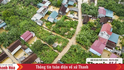
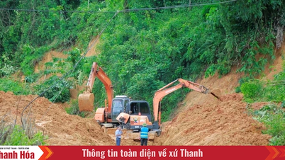
In the past 24 hours (from 1:00 a.m. on August 26 to 1:00 a.m. on August 27), Thanh Hoa province has had moderate to heavy rain, with some places experiencing very heavy rain. The amount of rain measured at automatic rain gauges is as follows: Thanh Tan 110mm, Ha Trung 96.8mm, Yen My 78.6mm, Yen Thang 77mm...
Soil moisture model shows that the current soil moisture status of some areas is close to saturation (over 85%) or has reached saturation.
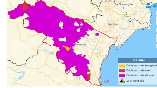
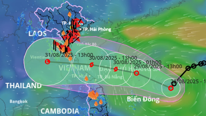
Map of flash flood and landslide risks in Thanh Hoa province
Warning in the next 6 hours, flash floods, landslides, and land subsidence are at very high risk of occurring in the communes of Muong Lat, Tam Chung, Muong Ly, Trung Ly, Nhi Son, Phu Nhi, Quang Chieu, Muong Chanh; Quan Son, Son Thuy, Na Meo, Muong Min, Son Dien, Trung Ha, Tam Lu, Tam Thanh; Hoi Xuan, Trung Son, Trung Thanh, Phu Le, Phu Xuan, Hien Kiet, Nam Xuan, Thien Phu; Ba Thuoc, Co Lung, Pu Luong, Quy Luong, Dien Lu, Thiet Ong, Dien Quang, Dien Lu, Van Nho; Van Phu, Dong Luong, Yen Thang, Yen Khuong, Linh Son, Giao An, Thuong Xuan, Bat Mot, Yen Nhan, Luong Son, Van Xuan, Luan Thanh, Tan Thanh, Thang Loc, Xuan Chinh; Nhu Xuan, Thuong Ninh, Thanh Quan, Thanh Phong, Hoa Quy, Xuan Binh; Nhu Thanh, Xuan Du, Mau Lam, Yen Tho, Xuan Thai, Thanh Ky; Thach Quang, Thanh Vinh, Thach Binh, Van Du, Kim Tan, Ngoc Trao; Cam Thuy, Cam Tu, Cam Thach, Cam Tan, Cam Van; Ngoc Lac, Thach Lap, Ngoc Lien, Minh Son, Nguyet An, Kien Tho.
Warning level of natural disaster risk due to flash floods, landslides, land subsidence due to rain, floods, and water flow: level 1.
NM
Source: https://baothanhhoa.vn/77-xa-co-nguy-co-rat-cao-xay-ra-lu-quet-sat-lo-dat-trong-6-gio-toi-259739.htm
![[Photo] General Secretary To Lam presents the 45-year Party membership badge to comrade Phan Dinh Trac](https://vphoto.vietnam.vn/thumb/1200x675/vietnam/resource/IMAGE/2025/8/28/e2f08c400e504e38ac694bc6142ac331)
![[Photo] Red flag with yellow star flutters in France on National Day September 2](https://vphoto.vietnam.vn/thumb/1200x675/vietnam/resource/IMAGE/2025/8/28/f6fc12215220488bb859230b86b9cc12)
![[Photo] Politburo works with the Standing Committee of Cao Bang Provincial Party Committee and Hue City Party Committee](https://vphoto.vietnam.vn/thumb/1200x675/vietnam/resource/IMAGE/2025/8/28/fee8a847b1ff45188749eb0299c512b2)
![[Photo] General Secretary To Lam attends the opening ceremony of the National Achievements Exhibition](https://vphoto.vietnam.vn/thumb/1200x675/vietnam/resource/IMAGE/2025/8/28/d371751d37634474bb3d91c6f701be7f)
![[Photo] National Assembly Chairman Tran Thanh Man holds talks with New Zealand Parliament Chairman](https://vphoto.vietnam.vn/thumb/1200x675/vietnam/resource/IMAGE/2025/8/28/c90fcbe09a1d4a028b7623ae366b741d)


Comment (0)