

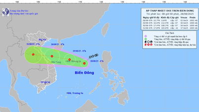
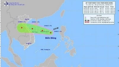
According to the National Center for Hydro-Meteorological Forecasting, at 1:00 p.m. this afternoon (August 28), the center of the tropical depression was located in the North East Sea, about 420 km east-southeast of Hoang Sa special zone. The strongest wind near the center of the tropical depression was level 6-7 (39-61 km/h), gusting to level 9; moving southwest at a speed of 10-15 km/h.

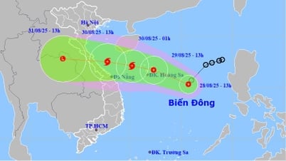
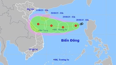
In the next 24 hours, the tropical depression will change direction, to the West Northwest, 15-20km/h and is likely to strengthen. At 1:00 p.m. on August 29, the center of the tropical depression will be located over the Hoang Sa special zone. The strongest wind near the center of the tropical depression is at level 7, gusting to level 9.
It is forecasted that in the next 12 hours, the tropical depression will maintain its direction and speed of movement, with the possibility of strengthening into a storm. If it strengthens into a storm, this will be the 6th storm in the East Sea in 2025.
At 1:00 p.m. on August 30, the center of the tropical depression that is likely to strengthen into a storm is located right over the sea of provinces from Nghe An to Da Nang . The storm intensity remains at level 8, gusting to level 10.
From the next 48 to 72 hours, the tropical depression (or storm) continues to move mainly in the West direction, traveling about 20km per hour and gradually weakening.
Due to the influence of the tropical depression, on the night of August 29 and August 30, the western sea area of the North East Sea (including Hoang Sa special zone) and the sea area from Thanh Hoa to Da Nang: strong winds level 6-7, near the storm center strong winds level 8, gusting to level 10; waves 2-5m high; rough seas.
Central and Southern East Sea area (including Truong Sa special zone): strong southwest wind level 6-7, gust level 8-9; waves 2-3.5m high; rough sea.
Sea area from Khanh Hoa to Ho Chi Minh City: strong southwest wind level 6, gusting to level 7-8; waves 2-3.5m high; rough sea. Natural disaster risk level due to strong winds at sea: level 2; especially the sea area east of the North East Sea area: level 3.
Ships operating in the above mentioned dangerous areas are susceptible to the effects of storms, whirlwinds, strong winds and large waves.
Central region heavy rain up to 600mm
The tropical depression is likely to strengthen into a storm heading towards the Central region, causing heavy rain in this area and expanding to the North.
Specifically, from the evening and night of August 29 to August 30, the midlands, the Northern Delta and Da Nang City will have moderate rain, heavy rain and thunderstorms (50-100mm, some places have very heavy rain over 200mm). The area from Thanh Hoa to Hue City will have heavy to very heavy rain (100-200mm, some places have over 350mm). There is a risk of rain intensity greater than 150mm/3 hours.
In addition, in the evening and night of August 28, the area from Thanh Hoa to Lam Dong and the South will have scattered showers and thunderstorms (10-30mm, some places have heavy rain over 80mm). Risk of heavy rain: >60mm/3 hours.
The meteorological agency warned that from the night of August 30 to August 31, heavy rains will continue in the midlands and the Northern Delta, from Thanh Hoa to Da Nang City. In particular, the rainfall in the midlands, the Northern Delta and Da Nang is from 50-100mm, locally over 200mm; from Thanh Hoa to Hue City is from 70-150mm, locally over 250mm.
Total rainfall from the evening and night of August 29 to August 31 in the midlands, the Northern Delta and Da Nang City is generally from 100-200mm, locally over 400mm; in the area from Thanh Hoa to Hue City, it is generally from 150-350mm, locally over 600mm.
Natural disaster risk level due to heavy rain, tornadoes, lightning, hail: level 1, especially in areas from Thanh Hoa to Quang Tri level 2.
The Meteorological Agency warns that areas with thunderstorms are likely to experience tornadoes, lightning, hail and strong gusts of wind. Heavy rains are likely to cause flooding in low-lying areas, urban and industrial areas; flash floods on small rivers and streams; and landslides on steep slopes.
Source: https://baolaocai.vn/bao-so-6-kha-nang-sap-hinh-thanh-trong-tam-mua-lon-o-mien-trung-post880746.html
![[Photo] Prime Minister Pham Minh Chinh meets with Speaker of the New Zealand Parliament Gerry Brownlee](https://vphoto.vietnam.vn/thumb/1200x675/vietnam/resource/IMAGE/2025/8/28/cec2630220ec49efbb04030e664995db)
![[Photo] Politburo works with the Standing Committee of Cao Bang Provincial Party Committee and Hue City Party Committee](https://vphoto.vietnam.vn/thumb/1200x675/vietnam/resource/IMAGE/2025/8/28/fee8a847b1ff45188749eb0299c512b2)
![[Photo] General Secretary To Lam attends the opening ceremony of the National Achievements Exhibition](https://vphoto.vietnam.vn/thumb/1200x675/vietnam/resource/IMAGE/2025/8/28/d371751d37634474bb3d91c6f701be7f)
![[Photo] Red flag with yellow star flutters in France on National Day September 2](https://vphoto.vietnam.vn/thumb/1200x675/vietnam/resource/IMAGE/2025/8/28/f6fc12215220488bb859230b86b9cc12)

![[Photo] General Secretary To Lam presents the 45-year Party membership badge to comrade Phan Dinh Trac](https://vphoto.vietnam.vn/thumb/1200x675/vietnam/resource/IMAGE/2025/8/28/e2f08c400e504e38ac694bc6142ac331)


Comment (0)