
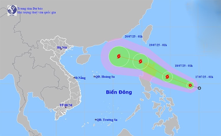
Specifically, within 24 hours (from 1:00 a.m. on July 17), the tropical depression moved rapidly in the west-northwest direction, traveling about 20 km per hour and strengthening into a storm.
At 1:00 a.m. on July 18, the storm center was in the sea east of Luzon Island, Philippines, with a strong intensity of level 8, gusting to level 10.
In the next 24-48 hours, the storm will move northwest, continuing to maintain a very fast speed of about 20-25 km/h and is likely to strengthen.
At 1:00 a.m. on July 19, the storm center was in the eastern part of the North East Sea with a strong intensity of level 10, gusting to level 12. Thus, in just one day, the storm could increase by 2 levels.
It is forecasted that in the next 48 to 72 hours, the storm will move mainly in the west-northwest direction, traveling 15-20 km per hour and may strengthen further.
According to the National Center for Hydro-Meteorological Forecasting, the forecast of the storm's development in the East Sea will be very complicated and unpredictable, requiring continuous updates of the latest forecasts.
Weather forecast for regions across the country:
Hai Phong area: According to the City Hydrometeorological Station, due to the influence of the low pressure area in the West that tends to develop and expand to the southeast, from July 17 to 18, the Hai Phong area will experience hot and extremely hot weather. The highest temperature is from 36 to 38 degrees Celsius.
Due to the effects of heat combined with low humidity in the air, there is a risk of explosions and fires in residential areas due to increased demand for electricity and the risk of forest fires. In addition, heat can also cause dehydration, exhaustion, and heat stroke in the human body when exposed to high temperatures for a long time.
Hanoi capital is cloudy, with showers and thunderstorms in some places in the late afternoon and at night; hot and sunny during the day. Light wind. During thunderstorms, there is a possibility of tornadoes, lightning, hail and strong gusts of wind. Lowest temperature 27 - 29 degrees Celsius. Highest temperature 34 - 36 degrees Celsius, some places above 36 degrees Celsius.
The Northwest region is cloudy, with scattered showers and thunderstorms at night, with some places having heavy rain; sunny during the day. Light wind. During thunderstorms, there is a possibility of tornadoes, lightning, hail and strong gusts of wind. The lowest temperature is 24 - 27 degrees Celsius, some places below 23 degrees Celsius. The highest temperature is 33 - 36 degrees Celsius, some places above 36 degrees Celsius.
The Northeastern provinces are cloudy, with scattered showers and thunderstorms in the late afternoon and evening, especially in mountainous areas at night with scattered showers and thunderstorms, with some heavy rain in some places; sunny during the day. Light wind. During thunderstorms, there is a possibility of tornadoes, lightning, hail and strong gusts of wind. The lowest temperature is 26 - 29 degrees Celsius. The highest temperature is 33 - 36 degrees Celsius, with some places above 36 degrees Celsius.
Source: https://baohaiphongplus.vn/ap-thap-nhiet-doi-kha-nang-manh-len-thanh-bao-khu-vuc-hai-phong-nang-nong-gay-gat-416535.html


![[Infographic] In 2025, 47 products will achieve national OCOP](https://vphoto.vietnam.vn/thumb/402x226/vietnam/resource/IMAGE/2025/7/16/5d672398b0744db3ab920e05db8e5b7d)


Comment (0)