
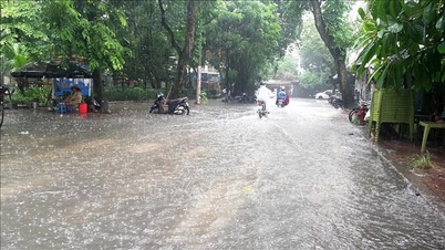
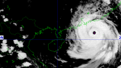
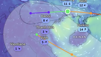
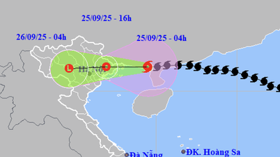
The National Center for Hydro-Meteorological Forecasting informed that on the afternoon of September 16, the low pressure area with symbol 99W in the sea east of Luzon Island (Philippines) strengthened into a tropical depression.

At 1 p.m., the center of the tropical depression was at about 15.3 degrees North latitude and 123.7 degrees East longitude, in the sea east of Luzon Island. The strongest wind near the center reached level 6-7 (39-61 km/h), gusting to level 9. The tropical depression was moving in a northwest direction at a speed of about 15 km/h.
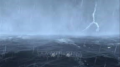
The National Center for Hydro-Meteorological Forecasting forecasts that in the next 24 hours, the tropical depression is likely to strengthen into a storm when approaching the sea northeast of Luzon Island. By 1 p.m. on September 17, the center of the storm may be at about 18.4 degrees North latitude and 122.7 degrees East longitude, with a strength of level 8, gusts of level 10. By 1 p.m. on September 18, the storm will move west-northwest at a speed of 15-20 km/h, likely to enter the East Sea and maintain a strength of level 8, gusts of level 10.

In the next 48 to 72 hours, the storm will continue to move mainly in the West-Northwest direction at a speed of about 15km/h, with little change in intensity. At sea, the Northeast region of the North East Sea will have winds gradually increasing to level 6, gusting to level 8; near the center of the storm will be strong at level 7-8, gusting to level 10. Waves will be 2.5-4.5m high. Ships operating in this area should be aware of the risk of thunderstorms, whirlwinds, strong winds and large waves.

Currently, the model predicting the direction of the tropical depression provided by the National Center for Hydro-Meteorological Forecasting (Vietnam) is similar to the forecast of the Japan Meteorological Forecasting Agency, and models from the United States and Europe.
Source: https://www.sggp.org.vn/ap-thap-nhiet-doi-manh-len-co-the-thanh-bao-post813294.html


![[Photo] Closing of the 1st Congress of Party Delegates of Central Party Agencies](https://vphoto.vietnam.vn/thumb/1200x675/vietnam/resource/IMAGE/2025/9/24/b419f67738854f85bad6dbefa40f3040)


![[Photo] Editor-in-Chief of Nhan Dan Newspaper Le Quoc Minh received the working delegation of Pasaxon Newspaper](https://vphoto.vietnam.vn/thumb/1200x675/vietnam/resource/IMAGE/2025/9/23/da79369d8d2849318c3fe8e792f4ce16)


Comment (0)