
Updated at 7:00 a.m. from the National Center for Hydro-Meteorological Forecasting, super typhoon Ragasa (typhoon No. 9 in 2025) has moved to coordinates of about 21.3 degrees North latitude - 113.9 degrees East longitude, about 380km east of Leizhou peninsula (China).
At this time, the storm is still at level 15-16, gusting over level 17. The National Center for Hydro-Meteorological Forecasting predicts that in the next 3 hours, the storm will move quickly in the West-Northwest direction, at a speed of about 20km/hour.

Vietnam's meteorological agency said that storm No. 9 will weaken when it moves towards the coast of Guangxi province (China). It is forecast that when it passes the Leizhou peninsula (China), the storm will decrease to level 11, gusting to level 13.
Compared with forecasts made before September 24, the current scenario shows that the storm's intensity will decrease as it moves rapidly into the Gulf of Tonkin and into the northern mainland on September 25.
What does the world think about storm Ragasa?
Updated on the morning of September 24, Vietnam time, many international meteorological agencies continue to issue urgent warnings about super typhoon Ragasa. The US Joint Typhoon Warning Center (JTWC) continues to classify Ragasa as a super typhoon, maintaining extremely strong winds before weakening as it approaches the southern mainland of China.

The Japan Meteorological Agency (JMA) also issued an urgent warning, stating that the danger zone in the East Sea expanded to the entire North East Sea and the North Bay, accompanied by widespread heavy rain. The European Center for Medium-Range Weather Forecasts (ECMWF) forecast that this morning, September 24, Ragasa would still have a very strong storm intensity, then rapidly weaken when it entered the coast of Guangxi Province (China).
In China, the Hong Kong Observatory (HKO) is issuing a level 10 warning for Typhoon Ragasa (the highest level on the special administrative region's warning scale).
Forecast of storm circulation causing widespread rain
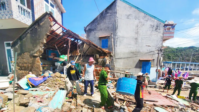
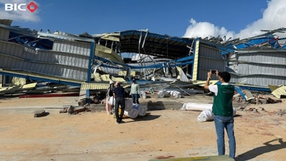
According to the meteorological agency, although the storm is no longer at the super typhoon level when it enters Vietnam, the circulation of storm No. 9 will still have a significant impact on the sea and mainland of the North. At sea, the North East Sea area will have strong winds of level 10-13, near the center of the super typhoon level 14-16, gusts above level 17, waves over 10m high, and rough seas.
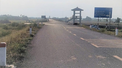
From noon today, September 24, the Northeast sea area including Bach Long Vi will have winds gradually increasing to level 6-7, gusting to level 9. From tonight, September 24, the Northern Gulf of Tonkin area (Bach Long Vi, Van Don, Co To, Cat Hai, Hon Dau) will have winds gradually increasing to level 8, the area near the storm center will have winds of level 9-11, gusting to level 13, waves 3-5m high, very rough seas.

Along with big waves, the coastal areas of Quang Ninh - Hai Phong have seen water levels rise by 0.4-0.6m, posing a high risk of landslides, embankments, and destruction of aquaculture areas and boats anchored along the shore. On land, from early morning on September 25, the coastal areas of Quang Ninh - Ninh Binh have experienced strong winds of level 6-7, near the storm center of level 8-9, gusting to level 11; deep inland in the Northeast, winds of level 5-6, gusting to level 7-8.
Mr. Mai Van Khiem, Director of the National Center for Hydro-Meteorological Forecasting, said that widespread heavy rain occurred from the night of September 24 to the end of the night of September 26 in the North, Thanh Hoa and Nghe An , with common rainfall of 100-250mm, in some places over 400mm.
Source: https://www.sggp.org.vn/sieu-bao-ragasa-se-giam-xuong-cap-11-truoc-khi-vao-viet-nam-post814419.html
![[Photo] General Secretary To Lam receives Vice President of Luxshare-ICT Group (China)](https://vphoto.vietnam.vn/thumb/1200x675/vietnam/resource/IMAGE/2025/11/15/1763211137119_a1-bnd-7809-8939-jpg.webp)
![[Photo] Prime Minister Pham Minh Chinh meets with representatives of outstanding teachers](https://vphoto.vietnam.vn/thumb/1200x675/vietnam/resource/IMAGE/2025/11/15/1763215934276_dsc-0578-jpg.webp)


![[Photo] Panorama of the 2025 Community Action Awards Final Round](https://vphoto.vietnam.vn/thumb/1200x675/vietnam/resource/IMAGE/2025/11/15/1763206932975_chi-7868-jpg.webp)


Comment (0)