
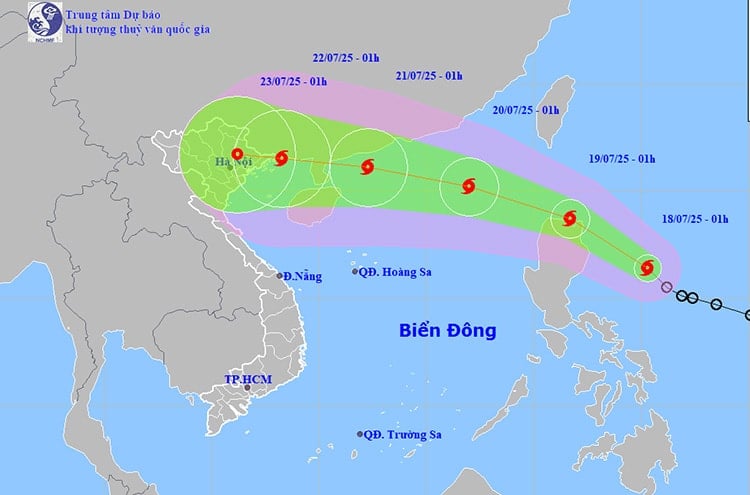
According to the National Center for Hydro-Meteorological Forecasting, at 1:00 a.m. on July 18, the center of storm WIPHA was at about 16.4 degrees North latitude - 125.3 degrees East longitude, in the sea east of Luzon Island (Philippines). The strongest wind near the center of the storm reached level 8 (62-74 km/h), gusting to level 10. The storm is moving northwest at a speed of about 20 km/h and is likely to strengthen.
In the next 24 hours, the storm will continue to move northwest, approaching the northern part of Luzon Island (Philippines). At 1:00 a.m. on July 19, the center of the storm will be at about 18.7 degrees north latitude - 121.7 degrees east longitude, maintaining winds of level 8-9, gusting to level 11. In the next 48-72 hours, storm WIPHA is likely to enter the East Sea, becoming the second storm of 2025.
Forecast by 1:00 a.m. on July 20, the storm is about 740 km east-southeast of Leizhou Peninsula (China), with strong winds of level 10, gusts of level 12. The dangerous area at sea is determined from latitude 17.5 to 22.5 degrees north and from longitude 115.5 to 120 degrees east. The level of natural disaster risk in the northeastern area of the East Sea is warned at level 3.
Continuing to move in the West-Northwest direction at a speed of 20 - 25km/h, by the early morning of July 21, the storm was about 220km from the Leizhou peninsula, strengthening to level 11, gusting to level 14. During this period, the northern sea area of the North East Sea will be heavily affected by strong winds, large waves from 2.5 - 3.5m, and rough seas. Authorities warn that ships operating in the dangerous area are at high risk of accidents due to strong winds, tornadoes and thunderstorms.
While the storm is approaching the East Sea, the Northern and Central regions are still experiencing a widespread heat wave. On July 17, temperatures in many places exceeded 37 degrees Celsius, and humidity dropped to only 55-60%.
Some places that recorded high temperatures include: Son Dong (formerly Bac Giang ) 38.2 degrees Celsius, Hoai Duc (Hanoi) 37.7 degrees Celsius, Bac Quang (formerly Tuyen Quang) and Chi Linh (formerly Hai Duong) both reached 37.5 degrees Celsius. Areas from Thanh Hoa to Da Nang, the East of Quang Ngai to Dak Lak and Khanh Hoa are also experiencing widespread heat, with common temperatures of 35-38 degrees Celsius, some places exceeding 38 degrees Celsius.
Particularly in Hai Phong, due to the influence of the low pressure area in the West that tends to develop and expand to the Southeast, on July 18 and 19, the Hai Phong area will experience hot and extremely hot weather.
harsh. Highest temperature from 36 - 38°C. Lowest relative humidity from 50 - 55%.
It is forecasted that on July 18-19, the heat wave will continue in the North and Central regions. In particular, the period from 10:00 to 17:00 is the time with the highest temperature of the day. In the Northern Delta, on July 19, the temperature will tend to decrease slightly, fluctuating between 35-36 degrees Celsius, and the humidity will increase to about 60-65%.
From July 20, the heat wave in the Northern Delta and Central regions is expected to gradually decrease. However, people still need to be aware of the risks of explosions and forest fires due to prolonged high temperatures, as well as the risks of stroke and dehydration when doing outdoor activities.
Weather forecast for regions across the country:
Hanoi capital has few clouds, hot and very hot days, no rain at night. Light wind. Lowest temperature 29-31 degrees Celsius. Highest temperature 36-38 degrees Celsius, some places over 38 degrees Celsius.
The Northwest region is cloudy, hot during the day, some places are very hot, in the evening and at night there are showers and thunderstorms in some places. Light wind. During thunderstorms there is a possibility of tornadoes, lightning, hail and strong gusts of wind. The lowest temperature is 26-29 degrees Celsius, in Lai Chau, Dien Bien, Son La 23-25 degrees Celsius. The highest temperature is 34-37 degrees Celsius, some places are over 37 degrees Celsius.
The northeastern provinces have few clouds, hot and very hot days, no rain at night. Light wind. Lowest temperature 26-29 degrees Celsius. Highest temperature 35-38 degrees Celsius, some places over 38 degrees Celsius.
Provinces from Thanh Hoa to Hue are cloudy, sunny during the day, some places are very hot, in the evening and at night there are showers and thunderstorms in some places. Light wind. During thunderstorms there is a possibility of tornadoes, lightning, hail and strong gusts of wind. Lowest temperature 27-30 degrees Celsius, some places over 30 degrees Celsius. Highest temperature 35-38 degrees Celsius, some places over 38 degrees Celsius.
The South Central Coast region is cloudy, sunny during the day, some places are very hot, in the evening and at night there are showers and thunderstorms in some places. Southwest wind level 2-3. During thunderstorms there is a possibility of tornadoes, lightning, hail and strong gusts of wind. The lowest temperature is 26-29 degrees Celsius. The highest temperature is 34-37 degrees Celsius, some places are over 37 degrees Celsius.
The Central Highlands is cloudy with scattered showers and thunderstorms, with scattered showers and thunderstorms in the afternoon and evening, with some heavy rain in some places. Southwesterly winds at level 2-3. There is a possibility of tornadoes, lightning and strong gusts of wind during thunderstorms. Lowest temperature 19-22 degrees Celsius. Highest temperature 27-30 degrees Celsius.
Southern region is cloudy with scattered showers and thunderstorms, with scattered showers and thunderstorms in the afternoon and evening, and heavy rain in some places. Southwesterly winds level 2-3. There is a possibility of tornadoes, lightning, and strong gusts of wind during thunderstorms. Lowest temperature 24-27 degrees Celsius. Highest temperature 30-33 degrees Celsius.
Ho Chi Minh City is cloudy with scattered showers and thunderstorms, with scattered showers and thunderstorms in the afternoon and evening, and heavy rain in some places. Southwesterly winds at level 2-3. There is a possibility of tornadoes, lightning, and strong gusts of wind during thunderstorms. Lowest temperature 24-26 degrees Celsius. Highest temperature 30-32 degrees Celsius.
Source: https://baohaiphongplus.vn/ap-thap-nhiet-doi-manh-len-thanh-bao-wipha-va-di-vao-bien-dong-hai-phong-nang-nong-gay-gat-416601.html


![[Infographic] In 2025, 47 products will achieve national OCOP](https://vphoto.vietnam.vn/thumb/402x226/vietnam/resource/IMAGE/2025/7/16/5d672398b0744db3ab920e05db8e5b7d)


Comment (0)