
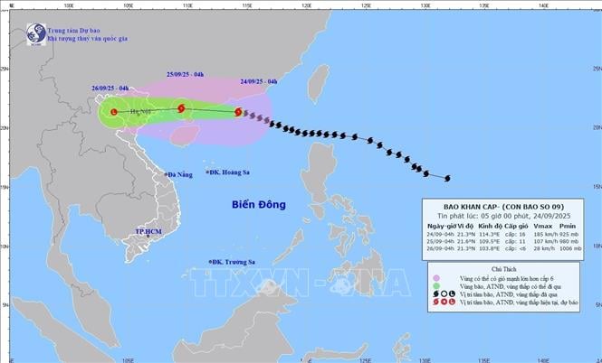
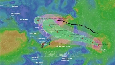
According to the National Center for Hydro-Meteorological Forecasting, at 7:00 a.m., the center of the storm was at about 21.3 degrees North latitude; 113.7 degrees East longitude, about 620 km east of Mong Cai ( Quang Ninh ). The strongest wind near the center of the storm was level 15 (167-183 km/h), gusting to level 17. Moving in the West Northwest direction at a speed of about 20 km/h.
The specific developments of storm No. 9 in the coming days are as follows:
At 7:00 a.m. on September 25, the storm was in the sea area of Quang Ninh - Hai Phong province with strong winds of level 10-11, gusting over level 13; moving northwest at 20-25 km per hour and gradually weakening. The affected area is the northern sea area of the North East Sea with disaster risk level 4; the northern Gulf of Tonkin, the Northeast with disaster risk level 3.
At 7:00 a.m. on September 26, the storm was on land in the Northwest region of the North with winds below level 6; moving westward at 25-30 km per hour and continuing to weaken into a tropical depression and then into a low pressure area. The affected area is the Northwest sea area of the North East Sea, the North Gulf of Tonkin, the Northeast with a level 3 natural disaster risk level.
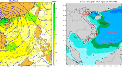
Due to the impact of the storm, the northern sea area of the North East Sea has strong winds of level 10-12, the area near the storm's eye has winds of level 13-15, gusts over level 17, waves over 10m high; rough seas.
From noon on September 24, the sea area in the East of the North Gulf of Tonkin (including Bach Long Vi special zone) has gradually increased winds to level 6-7, gusts to level 9. From the night of September 24, the area in the North Gulf of Tonkin (including Bach Long Vi special zone, Van Don, Co To, Cat Hai and Hon Dau island) has gradually increased winds to level 8, waves 2-4m high, the area near the storm center has level 9-11, gusts to level 13, waves 3-5m high; the sea is very rough.
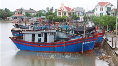
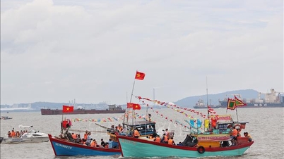
The coastal areas of Quang Ninh province have storm surges of 0.4 - 0.6 meters high. Ships and boats anchored along the coast and aquaculture areas are strongly affected by strong winds, big waves and rising sea levels.
On land: From early morning on September 25, coastal areas from Quang Ninh to Ninh Binh will have winds gradually increasing to level 6-7, near the storm center level 8-9, gusting to level 11; inland areas in the Northeast, there will be strong winds of level 5, in some places level 6, gusting to level 7-8.
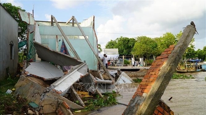
From the night of September 24 to the end of the night of September 26, in the Northern region, Thanh Hoa and Nghe An, there will be heavy to very heavy rain with common rainfall of 100-250mm, locally over 400mm. Beware of heavy rain causing urban flooding.
Heavy rains can cause flooding in low-lying areas; flash floods in small rivers and streams, and landslides on steep slopes.
Source: https://baotintuc.vn/van-de-quan-tam/bao-di-vao-phia-nam-tinh-quang-dong-trung-quoc-va-giam-cap-khong-con-cap-sieu-bao-20250924083548198.htm

![[Photo] Closing of the 1st Congress of Party Delegates of Central Party Agencies](https://vphoto.vietnam.vn/thumb/1200x675/vietnam/resource/IMAGE/2025/9/24/b419f67738854f85bad6dbefa40f3040)


![[Photo] Editor-in-Chief of Nhan Dan Newspaper Le Quoc Minh received the working delegation of Pasaxon Newspaper](https://vphoto.vietnam.vn/thumb/1200x675/vietnam/resource/IMAGE/2025/9/23/da79369d8d2849318c3fe8e792f4ce16)


![[Photo] Solemn opening of the 1st Congress of Party Delegates of Central Party Agencies](https://vphoto.vietnam.vn/thumb/402x226/vietnam/resource/IMAGE/2025/9/24/82a89e250d4d43cbb6fcb312f21c5dd4)


Comment (0)