
(CPV) – This morning, storm MAN-YI has strengthened to level 16, gusting to level 17, a super typhoon; it is expected that around the morning of November 18, storm MAN-YI will move into the East Sea, becoming the ninth storm affecting our country during this year's storm and flood season. Storm USAGI will make landfall in the Taiwan area (China) then weaken into a tropical depression and gradually dissipate.
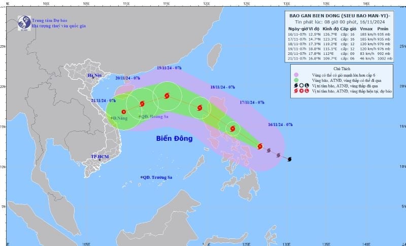 |
| Location and direction of storm MAN-YI on the morning of November 16. Photo: Center for Hydro-Meteorological Forecasting |
The above information was announced by Mr. Nguyen Van Huong, Head of Climate Forecast Department (National Center for Hydro-Meteorological Forecasting) on the morning of November 16.
According to Mr. Huong, this morning (November 16), storm MAN-YI has strengthened to level 16, gusting over level 17, super typhoon level and the location of super typhoon MAN-YI at 7am this morning was at about 12.5 degrees North latitude; 126.7 degrees East longitude, in the sea east of the central Philippines. The strongest wind near the center of the super typhoon is level 16 (184-201km/h), gusting over level 17. Moving in the West Northwest direction, speed 20-25km/h.
It is forecasted that in the next 24 hours, super typhoon MAN-YI will move mainly in the northwest direction at a speed of about 20-25km/h and maintain a level 16 intensity; by tomorrow afternoon (November 17), super typhoon MAN-YI will make landfall in the Luzon Island area (Philippines) and gradually weaken. Around the morning of November 18, typhoon MAN-YI will move into the East Sea, becoming the 9th typhoon affecting our country during this year's storm and flood season.
"It is worth noting that the time when storm MAN-YI moves into the East Sea is also the time when the East Sea is affected by a strong cold air mass. The interaction of the cold air and storm MAN-YI will cause many changes in the intensity and direction of storm MAN-YI. However, the most important thing to note at this time is that the interaction of the cold air and storm MAN-YI will make the weather in the East Sea region very bad in the coming days, with strong winds, high waves and rough seas. The development of this storm MAN-YI will still have many changes, so it is necessary to closely monitor," said Mr. Huong.
According to Mr. Huong, in addition to storm MAN-YI, there is also storm USAGI active in the eastern area of the northeastern sea of the East Sea. It is forecasted that today, storm USAGI will make landfall in the Taiwan area (China) and then weaken into a tropical depression and dissipate.
Regarding the cold air situation, Mr. Huong said that currently (November 16), in the North, a cold air mass is moving south; around the afternoon and night of November 17, this cold air mass will affect the Northeast; then affect the North Central region, most places in the Northwest and some places in the Central Central region. The Northeast wind inland will strengthen to level 3, coastal areas to level 4.
From November 18, in the Northeast and Thanh Hoa, the weather will turn cold at night and early morning; from November 20, in the North and North Central regions, the weather will be cold at night and early morning. The lowest temperature during this cold air mass in the North and North Central regions will generally be from 18-20 degrees Celsius, in mountainous areas, some places will be below 15 degrees Celsius./.
Source: https://dangcongsan.vn/xa-hoi/bao-man-yi-manh-len-thanh-sieu-bao-bao-usagi-yeu-va-tan-dan-683400.html


![[Maritime News] More than 80% of global container shipping capacity is in the hands of MSC and major shipping alliances](https://vphoto.vietnam.vn/thumb/402x226/vietnam/resource/IMAGE/2025/7/16/6b4d586c984b4cbf8c5680352b9eaeb0)


Comment (0)