
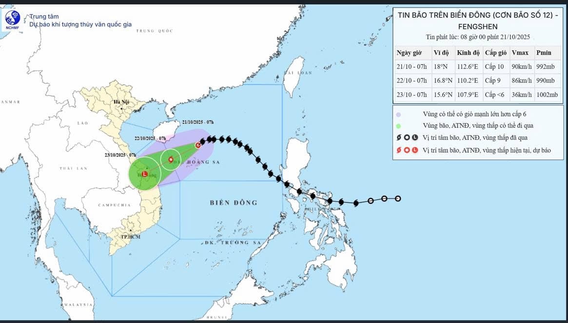
According to the National Center for Hydro-Meteorological Forecasting, this morning (October 21), storm No. 12 is in the North East Sea with strong winds of level 10, gusts of level 12, forecast to directly affect provinces from Da Nang to Quang Ngai, causing heavy rain and the risk of flash floods and widespread inundation.
At 7:00 a.m. this morning, the center of storm No. 12 was at about 18.0°N - 112.6°E, about 130 km north of Hoang Sa archipelago.
The strongest wind near the storm center is level 9-10 (75-102 km/h), gusting to level 12. The storm moves west at a speed of about 20 km/h.
 |
Forecast developments in the next 24-48 hours:
By 7am on October 22: The storm is moving in a West-Southwest direction at a speed of 10-15 km/hour, with the center of the storm at approximately 16.8°N - 110.2°E, approximately 220 km East-Northeast of Da Nang. Wind force is level 9, gusting to level 11.
Dangerous area in the East Sea: from latitude 15.5° to 20.0°N; longitude 108.5° to 114.5°E.
Disaster risk level: Level 3 (Northern East Sea area, including Hoang Sa archipelago).
At 7:00 a.m. on October 23: The storm continued to move southwest at a speed of about 10 km/hour, entering the mainland of the provinces from Da Nang to Quang Ngai , then gradually weakened into a tropical depression and then into a low pressure area (wind force below level 6).
Disaster risk level: Level 3 (area from South Quang Tri to Quang Ngai, including Ly Son island).
Impact of storm:
At sea: The North East Sea area (including Hoang Sa archipelago) has strong winds of level 7-8, near the storm center level 9-10, gusting to level 12; waves from 3-7 m high, very rough seas.
The sea area from South Quang Tri to Quang Ngai (including Ly Son) has strong winds of level 6-7, near the storm center level 8, gusting to level 10; waves 3-5 m high, rough seas.
Vessels operating in the danger zone are at high risk of encountering storms, whirlwinds, strong gusts of wind and large waves.
On land: From the night of October 22 to October 27, due to the influence of storm circulation combined with cold air and easterly winds, the area from Ha Tinh to Quang Ngai will experience widespread heavy rain.
Ha Tinh - Northern Quang Tri and Quang Ngai area: common rainfall 200-400 mm, some places over 500 mm.
Southern Quang Tri - Da Nang area: rainfall 500-700 mm, some places exceed 900 mm.
There is a high risk of flash floods and landslides in mountainous areas and flooding in low-lying areas and urban areas. Localities need to strengthen inspections and ensure the safety of reservoirs and hydroelectric and irrigation works, and proactively prepare response plans for heavy rain and floods that may exceed alert level 3.
Disaster risk level due to floods: Level 3.
According to PV/VOV.VN
Source: https://baovinhlong.com.vn/tin-moi/202510/bao-so-12-ap-sat-mien-trung-tu-da-nang-den-quang-ngai-mua-lon-1ab0a8c/


![[Photo] Prime Minister Pham Minh Chinh received Mr. Yamamoto Ichita, Governor of Gunma Province (Japan)](https://vphoto.vietnam.vn/thumb/1200x675/vietnam/resource/IMAGE/2025/10/21/1761032833411_dsc-8867-jpg.webp)

![[Photo] Da Nang residents "hunt for photos" of big waves at the mouth of the Han River](https://vphoto.vietnam.vn/thumb/1200x675/vietnam/resource/IMAGE/2025/10/21/1761043632309_ndo_br_11-jpg.webp)
![[Photo] Prime Minister Pham Minh Chinh meets with Speaker of the Hungarian National Assembly Kover Laszlo](https://vphoto.vietnam.vn/thumb/1200x675/vietnam/resource/IMAGE/2025/10/20/1760970413415_dsc-8111-jpg.webp)


Comment (0)