

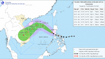
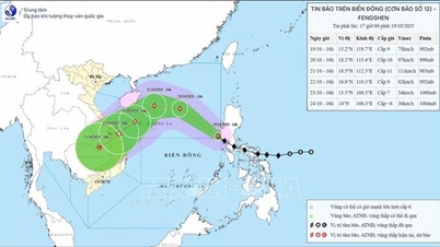
According to the National Center for Hydro-Meteorological Forecasting, storm No. 12 (Fengshen storm) has not changed in intensity and direction of movement, the storm is about 750km from Hoang Sa special zone and is likely to strengthen in the next 24 hours.
Accordingly, at 7:00 p.m. on October 19, the center of the storm was at about 15.6 degrees North latitude; 119.0 degrees East longitude, about 750km East Southeast of Hoang Sa special zone. The strongest wind near the center of the storm was level 9 (75-88km/h), gusting to level 11. Moving northwest at a speed of about 25km/h.
Forecast by 7:00 p.m. on October 20, the storm is in the North East Sea, about 330 km northeast of Hoang Sa special zone, with strong winds of level 10-11, gusting to level 13, moving northwest at a speed of about 20-25 km/h and likely to strengthen. The affected area is the North East Sea (including Hoang Sa special zone). Disaster risk level 3.
At 7:00 p.m. on October 21, the storm was in the northwest sea of the North East Sea, about 180km north of Hoang Sa special zone, with strong winds of level 11, gusts of level 13, moving west at a speed of about 10-15km/h and likely to intensify. The affected area is the North East Sea (including Hoang Sa special zone). Disaster risk level 3.
At 7:00 p.m. on October 22, the storm was in the sea from Hue city to Quang Ngai, about 130km east of Da Nang city, with strong winds of level 9, gusting to level 11, moving southwest at a speed of about 10-15km/h and likely to weaken.
The affected area is the western sea area of the North East Sea (including Hoang Sa special zone), the sea area from Hue city to Quang Ngai . Natural disaster risk level 3.
From the next 72 to 96 hours, the storm will move mainly in the southwest direction, about 10km per hour and gradually weaken into a low pressure area.
Due to the storm's influence, the North East Sea area (including Hoang Sa special zone) has strong winds of level 7-8; the area near the storm's eye has strong winds of level 9-11, gusting to level 13; waves 3-5m high, the area near the storm's eye has waves 5-7m high, and the sea is very rough.
All ships and boats operating in the above mentioned dangerous areas are susceptible to the impact of storms, whirlwinds, strong winds and large waves.
On land: Due to the influence of storm circulation and cold air, from October 22 to 27, the area from Ha Tinh to Quang Ngai is likely to have widespread heavy rain.
Localities need to prepare response plans for flood scenarios on rivers from Quang Tri to Quang Ngai that could reach alert level 3 and above. Forecast level of flood disaster risk: level 3./.
PVSource: https://baohaiphong.vn/bao-so-12-tien-gan-bien-dong-co-kha-nang-manh-them-trong-24-gio-toi-524062.html


Comment (0)