
At 7:00 a.m. on December 1, the center of the storm was at about 14.7 degrees North latitude; 111.6 degrees East longitude, in the northwest sea area of the Central East Sea.
The strongest wind near the storm center is level 8 (62-74km/h), gusting to level 10. Moving slowly to the West.
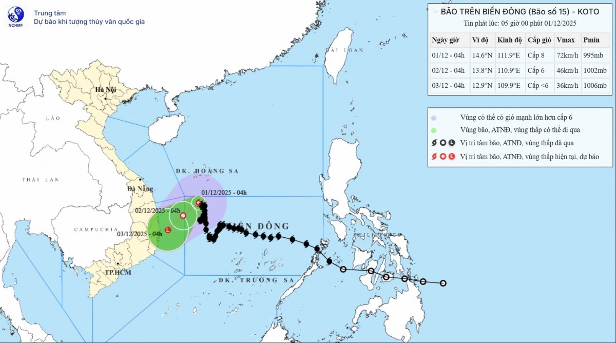
Storm forecast (in the next 24 to 72 hours) : At 7:00 a.m. on December 2, the storm moved to the Southwest, about 5km/h; located at 13.80N–110.80E, in the Northwest sea area of the Central East Sea, about 170km east of the East coast of Gia Lai – Dak Lak province.
Gradually weakening intensity, level 6, gust level 8. Danger zone from 12.00N–15.50N; west of longitude 112.00E. Natural disaster risk level 3: Northwest sea area of the Central East Sea, sea area from Gia Lai to Khanh Hoa.
At 7:00 p.m. on December 2 , the storm moved in the Southwest direction, about 10km/h; position 12.70N–110.10E, on the sea from Gia Lai to Khanh Hoa; weakened into a low pressure area, wind below level 6.
Storm impact forecast: Strong winds, big waves. At sea, the northwest sea area of the Central East Sea has strong winds of level 6; near the storm's eye, strong winds of level 7-8, gusts of level 10; waves 2.0-4.0m high, near the storm's eye 3.0-5.0m; rough seas.
Vessels operating in the above mentioned dangerous areas are susceptible to the impact of storms, whirlwinds, strong winds and large waves.
Source: https://baolaocai.vn/bao-so-15-dang-suy-yeu-tren-khu-vuc-phia-tay-bac-bien-dong-post887902.html


Comment (0)