
According to the National Center for Hydro-Meteorological Forecasting, currently (November 28), a tropical depression is active in the coastal area of East Malaysia.
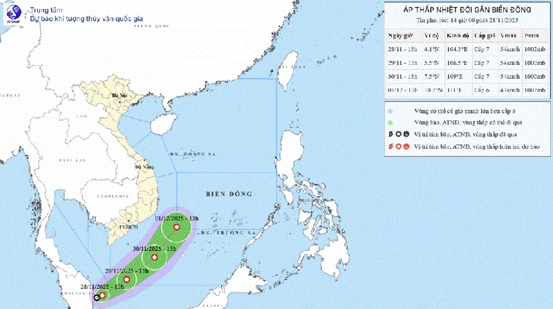
At 1 p.m. today (November 28), the center of the tropical depression was at about 4.1 degrees North latitude; 104.3 degrees East longitude, on the eastern coastal area of Malaysia. The strongest wind near the center of the tropical depression was level 6-7 (39-61 km/h), gusting to level 9. Moving northeast at a speed of about 15 km/h.
According to the meteorological agency, this tropical depression originated from storm Senyar, moving from the Indian Ocean region, passing through Malaysia to the Northwest Pacific region.
It is forecasted that in the next 24 hours, the tropical depression will continue to move in a northeast direction at a speed of about 15km/h; possibly crossing the 5th parallel and entering the East Sea, towards the center of storm No. 15.
Due to the impact of the tropical depression, the southwestern sea area of the South East Sea has winds gradually increasing to level 6-7, gusting to level 9, with waves 2.5-4.0m high. Rough seas.
Vessels operating in the above mentioned dangerous areas are susceptible to the impact of storms, whirlwinds, strong winds and large waves.
Meteorological experts assess that this is a rare case in the history of world meteorology. Normally, storms and tropical depressions rarely form at latitudes below 5 because the Coriolis force - the force that causes objects to move in a small direction - is small. That is also the reason why the South has fewer storms than the North and Central regions.
Meanwhile, storm No. 15 Koto is in the central East Sea, now with a newly formed tropical depression, the storm's developments become even more complicated.
According to the National Center for Hydro-Meteorological Forecasting, as of 1 p.m. this afternoon, the eye of the storm was approximately 190 km northwest of Song Tu Tay Island. The strongest wind near the eye of the storm was level 10 (89-102 km/h), gusting to level 13, down 2 levels compared to last night and constantly changing direction.
Currently, the storm is moving southwest at a speed of 5km/h. It is forecasted that in the next 1-2 days, storm No. 15 will move northwest at a speed of about 5km/h and continue to weaken.
On November 30, the storm changed direction to move west; on December 1, it moved west-southwest (weakening by about 1 level each day on average), possibly weakening into a tropical depression when moving into the sea off Quang Ngai - Dak Lak (formerly Phu Yen ).
Source: https://cand.com.vn/doi-song/bao-so-15-suy-yeu-nhanh-xuat-hien-ap-thap-nhiet-doi-co-huong-di-la--i789557/


Comment (0)