
It is forecasted that in the next 12 hours, the storm will continue to move in the West-Southwest direction at a speed of 10-15km/h. By around 1pm today, the storm will be in the coastal waters from Quang Ninh to Ninh Binh with an intensity of level 10, gusting to level 13. The storm will affect the Gulf of Tonkin, coastal waters and mainland provinces from Quang Ninh to Thanh Hoa with a natural disaster risk level of level 3.
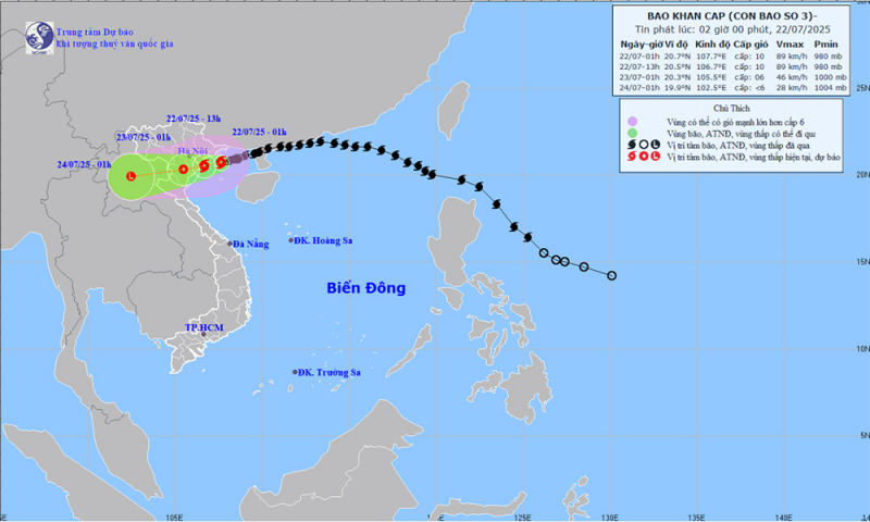
Meteorological experts warn that the northern Gulf of Tonkin (including the special zones of Bach Long Vi, Co To, Van Don, Cat Hai, Hon Dau island) will have strong winds of level 7-8, near the eye of the storm level 9-10, gusting to level 13; waves 2.0-4.0m high, near the eye of the storm 4.0-6.0m; very rough seas. The southern Gulf of Tonkin (including Hon Ngu island) will have strong winds of level 6-7, near the eye of the storm level 8, gusting to level 11; waves 2.0-4.0m high; rough seas.
The coastal areas of Hung Yen-Quang Ninh have storm surges of 0.5-1.0m high. Water levels in Ba Lat (Hung Yen) are 2.4-2.6m high, Hon Dau ( Hai Phong ) are 3.9-4.3m high, in Cua Ong (Quang Ninh) are 4.6-5.0m high and in Tra Co (Quang Ninh) are 3.6-4.0m high. There is a high risk of flooding in coastal areas and river mouths on the afternoon of July 22.
The weather at sea and in coastal areas during storms is extremely dangerous and unsafe for any means or structures operating in dangerous areas such as: cruise ships, passenger ships, transport ships, cages, rafts, aquaculture areas, dykes, embankments, coastal routes. Vehicles are highly likely to capsize, be destroyed, or be flooded due to strong winds, storms, whirlwinds, large waves, and rising sea levels.
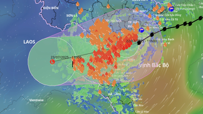
In addition, from early this morning to July 23, in the Northern Delta, Thanh Hoa and Nghe An, there will be heavy to very heavy rain and thunderstorms with common rainfall of 200-300mm, locally over 500mm; other places in the Northern region and Ha Tinh will have moderate rain, heavy rain, locally very heavy rain and thunderstorms with common rainfall of 70-150mm, locally over 250mm. Warning of the risk of heavy rain (>150mm/3 hours). Heavy rain in a short period of time can cause flash floods, landslides in mountainous areas, and flooding in low-lying areas.

Weather nationwide on Tuesday (July 22), Hanoi capital is cloudy, with heavy to very heavy rain. Wind gradually increases to level 6, gusting to level 7-8. Lowest temperature 24-26 degrees. Highest temperature 27-29 degrees.
Northwest region is cloudy with moderate rain, heavy rain and thunderstorms, locally very heavy rain. West to northwest wind level 2-3. Lowest temperature 23-26 degrees, some places below 22 degrees. Highest temperature 27-30 degrees, some places above 30 degrees.
The Northeast region is cloudy with moderate to heavy rain, especially in the plains. In the provinces/cities of Hai Phong, Hung Yen, Ninh Binh, the wind is strong at level 6, gusting at level 7-8, especially in the coastal areas from Quang Ninh to Ninh Binh, the wind gradually increases to level 7-8, near the storm center it increases to level 9-10, gusting at level 13. Other areas have winds gradually increase to level 3-4. The lowest temperature is 23-26 degrees, some places below 22 degrees. The highest temperature is 27-30 degrees, especially in the mountainous areas, some places are above 30 degrees.
From Thanh Hoa to Hue, it is cloudy, with moderate rain, heavy rain and thunderstorms in the North, especially Thanh Hoa-Nghe An, with heavy to very heavy rain; scattered showers and thunderstorms in the South. The coastal areas of Thanh Hoa-Nghe An gradually increase in strength to level 7-8, near the storm center, level 9-10, gusting to level 13; in the inland areas of Thanh Hoa, strong winds of level 6, gusting to level 7-8. In other places, southwest winds of level 3-4. The lowest temperature is 24-27 degrees. The highest temperature is 26-29 degrees, in some places in the South, it is over 30 degrees.
South Central Coast cloudy, scattered showers and thunderstorms. Southwest wind level 3-4. Lowest temperature 26-29 degrees. Highest temperature 31-34 degrees.
The Central Highlands is cloudy with scattered showers and thunderstorms, with scattered showers and thunderstorms in the afternoon and evening, with some heavy rain in some places. Southwesterly winds level 3-4. Lowest temperature 20-23 degrees. Highest temperature 25-28 degrees, with some places above 28 degrees.
The South is cloudy with scattered showers and thunderstorms, with scattered showers and thunderstorms in the afternoon and evening, with heavy rain in some places. Southwesterly wind level 3. Lowest temperature 23-26 degrees. Highest temperature 30-33 degrees, with some places above 33 degrees.
Ho Chi Minh City is cloudy with scattered showers and thunderstorms, with scattered showers and thunderstorms in the afternoon and evening, and heavy rain in some places. Southwest wind level 3. Lowest temperature 23-26 degrees. Highest temperature 31-33 degrees.
Source: https://cand.com.vn/doi-song/bao-so-3-do-bo-mien-bac-mua-rat-to-gio-manh-i775523/


Comment (0)