
Storm approaches, affecting 18 mainland provinces and cities
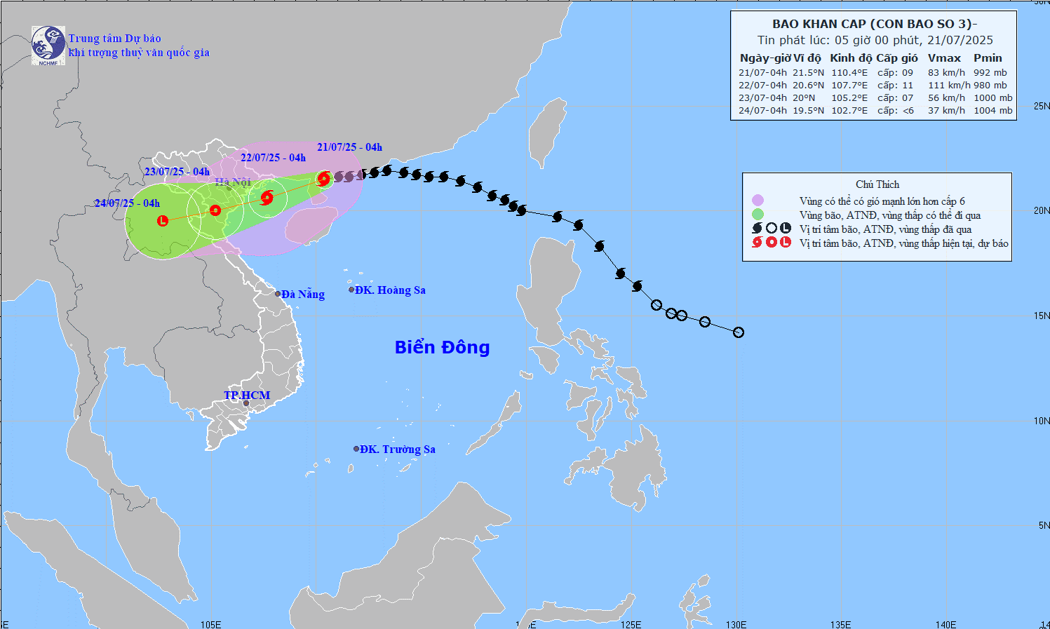
The National Center for Hydro-Meteorological Forecasting said that at 4:00 a.m. this morning (July 21), the center of storm No. 3 was about 275 km east of Quang Ninh - Hai Phong ; the strongest wind was level 9, gusting to level 11. The storm is currently moving into the northern Gulf of Tonkin and strengthening, then making landfall in the provinces of Hung Yen - Thanh Hoa on July 22 with an intensity of level 6-7, gusting to level 9.
Due to the storm's impact, coastal areas from Quang Ninh to Nghe An will have strong winds of level 7-9, near the storm's eye level 10-11, gusting to level 14. Inland areas will have winds of level 6-7, gusting to level 8-9. Waves will be 3-5m high, with rough seas. A water level rise of 0.8-1.2m may cause flooding in coastal areas of Quang Ninh and Hai Phong at noon and in the afternoon of July 22.
Heavy rains occurred over a wide area from the Northeast to the North Central region, with rainfall ranging from 200-350mm, with some places experiencing more than 600mm. In mountainous and midland areas, there is a high risk of flash floods and landslides; low-lying urban areas are at risk of widespread flooding.
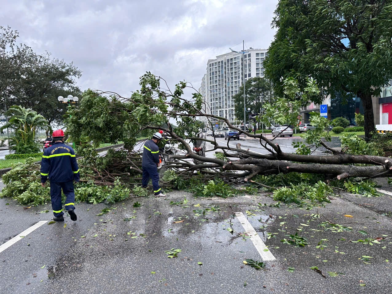
Hanoi has strong winds, very heavy rain, risk of tree fall and flooding
In Hanoi, from tonight (July 21), the northern and western areas of Hanoi (including forecast locations: Bat Bat, Ba Vi, Son Tay, Xuan Mai, Hoa Lac, Quoc Oai, Hoai Duc, Soc Son) will have winds gradually increasing to level 5, sometimes level 6, gusting to level 7. The southern and central areas of the city (including forecast locations: Tu Liem, Thuong Cat, Dong Anh, Phu Xuyen, Van Dinh, Chuong My, Thanh Tri, Thanh Oai, Ba Dinh, Lang, Gia Lam, Thanh Xuan, Hoang Mai, Hoan Kiem, Ha Dong) will have winds gradually increasing to level 5, level 6, then increasing to level 7, gusting to level 8-9.
With such intensity, strong winds will break branches, fall trees, power poles, blow off roofs of houses and livestock barns, endangering human lives.
In addition to strong winds, Hanoi's weather from today (July 21) to the morning of July 24 will have moderate rain, heavy rain, very heavy rain and thunderstorms in some places. Rainfall in the northern part of the city (including forecast locations: Me Linh, Dong Anh, Soc Son): 100-200mm, some places higher than 250mm. The central, western and southern areas of the city (including forecast locations: Tu Liem, Thuong Cat, Phu Xuyen, Van Dinh, Chuong My, Thanh Tri, Thanh Oai, Ba Dinh, Lang, Gia Lam, Thanh Xuan, Hoang Mai, Hoan Kiem, Ha Dong, Bat Bat, Ba Vi, Son Tay, Xuan Mai, Hoa Lac, Quoc Oai, Hoai Duc) 150-250mm, some places higher than 300mm.
Heavy rains pose a risk of flooding inner-city roads, traffic congestion, slippery roads, and accidents. Suburban areas may experience widespread flooding, crop damage, and landslides in steep hilly areas.
People should pay attention to skills to cope with strong winds and heavy rains.
To ensure safety of life and reduce property damage, people in the capital need to check and reinforce windows, roofs, electrical and drainage systems. Stock up on food, drinking water, flashlights, spare batteries and essential medicines. Fully charge communication devices...
When strong winds appear, people should stay indoors, unplug the power cord, turn off the circuit breaker if lightning occurs or heavy rain floods the house; should not participate in traffic or go outside unless absolutely necessary. When outdoors, stay away from glass doors, large trees, signs, unfinished construction works...
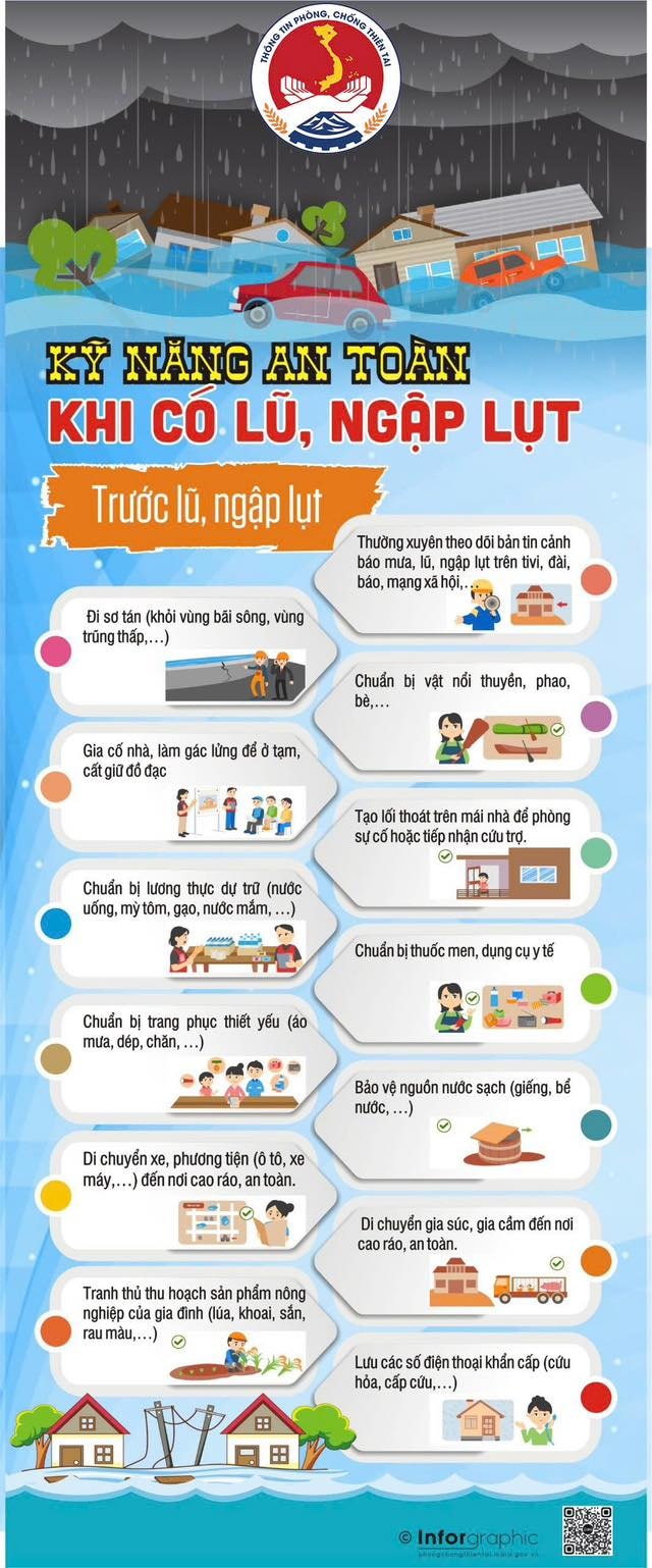
After the wind calms down, people should be cautious of downed power lines, fallen trees, collapsed houses, and damaged structures. Limit contact with flooded water to avoid infection and electrical accidents. At the same time, coordinate with the authorities and functional forces in overcoming the consequences.
Source: https://hanoimoi.vn/bao-so-3-gay-gio-manh-mua-lon-tai-ha-noi-va-nhieu-tinh-thanh-pho-709780.html


![[Photo] National Assembly Chairman Tran Thanh Man visits Vietnamese Heroic Mother Ta Thi Tran](https://vphoto.vietnam.vn/thumb/1200x675/vietnam/resource/IMAGE/2025/7/20/765c0bd057dd44ad83ab89fe0255b783)


Comment (0)