
Many rivers and floods have reached above historical flood levels and are slowly receding. Meanwhile, water levels along the Southeast coast remain high.
Currently, the tide level in the Southeast coast is at a high level. The water level observed at Vung Tau station is 4.05 m at 2:15 a.m. on October 9.
It is forecasted that water levels along the Southeast coast will remain high. The highest water level at Vung Tau station is forecast to range from 4.1 to 4.15 m.
Low-lying coastal areas, riverside areas, and areas outside the dike system in the Southeast region are likely to be flooded in the late afternoon.
This high tide ends on October 11.
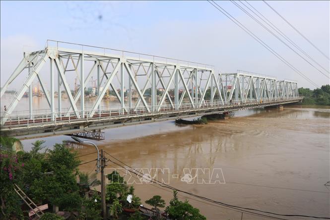
Exceptionally large floods on Cau River and Thuong River
Currently, the flood on Cau River (Thai Nguyen) at Gia Bay station and Trung River (Lang Son) at Huu Lung station is receding. The flood on Cau River ( Bac Ninh ) is rising. The flood on Thuong River (Bac Ninh) has peaked at 7.6 m (at 3:00 a.m. on October 9), 1.3 m above the historical flood level in 1986 and is changing slowly.
Water levels at 7:00 a.m. on October 9 on the rivers were as follows: On the Cau River at Gia Bay station 27.42 m, 0.42 m above alert level 3, at Dap Cau station 7.28 m, 0.98 m above alert level 3; on the Thuong River at Cau Son station 18.37 m, 2.37 m above alert level 3; at Phu Lang Thuong station 7.6 m, 1.3 m above alert level 3, 0.08 m above the historical flood of 1986 (7.52 m). On the Trung River at Huu Lung station 23.54 m, 1 m above the historical level of 1986 (22.54 m).
In the next 12 hours, the flood on Cau River is likely to peak, the flood peak at Dap Cau station (Bac Ninh) will be about 1.3m above alert level 3; the flood on Thuong River at Phu Lang Thuong station, on Trung River at Huu Lung station will decrease and be above alert level 3; the flood on Cau River at Gia Bay station will continue to decrease at alert level 2.
In the next 12-24 hours, floods on rivers will continue to decrease, water level on Cau River at Gia Bay station is below alarm level 1, at Dap Cau station is above alarm level 3; flood on Thuong River at Cau Son station, Phu Lang Thuong station, on Trung River at Huu Lung station is above alarm level 3.
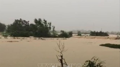
Widespread flooding in Thai Nguyen, Bac Ninh, Lang Son provinces in the next 2-3 days and risk of flooding in low-lying areas along rivers, urban areas in the Northern region; risk of landslides on river banks, river dykes and landslides on slopes in mountainous areas of the Northern region. Flood risk warning level is level 3.
River floods inundate low-lying areas along the river, affecting activities such as waterway transport, aquaculture, agricultural production, people's lives and socio- economic activities.
Source: https://baotintuc.vn/xa-hoi/canh-bao-trieu-cuong-ven-bien-dong-nam-bo-20251009115920304.htm

![[Photo] Impressions of the Can Gio Whale Festival](https://vphoto.vietnam.vn/thumb/1200x675/vietnam/resource/IMAGE/2025/10/09/1759984089762_image12334-5642-jpg.webp)

![[Photo] Prime Minister Pham Minh Chinh chairs the Conference to deploy the National Target Program on Drug Prevention and Control until 2030](https://vphoto.vietnam.vn/thumb/1200x675/vietnam/resource/IMAGE/2025/10/09/1759990393779_dsc-0495-jpg.webp)


Comment (0)