

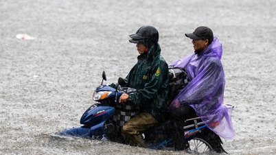
Specifically, the report of the Road Management Office I.3 said that at 6:00 a.m. on October 10, there was no rain, however, there was a situation of local flooding at Km28+800- Km29+050 TT, about 150m long, in the direction of Thai Nguyen - Hanoi, with a flooding depth of about 60cm; at Km28+850- Km29+050 PT, about 100m long, in the direction of Hanoi - Thai Nguyen, with a flooding depth of about 15cm.
The functional units coordinated with the Traffic Police force - PC Department - 08, Thai Nguyen Provincial Police to regulate traffic at Yen Binh intersection, Km41+350(T).
At the same time, coordinate with Traffic Police Team 15 - PC Department - 08 Hanoi City Police to regulate traffic to ensure safety for people and vehicles at Km29+250 (P).

Thereby, the units have diverted vehicles with less than 9 seats from Hanoi - Thai Nguyen, old Bac Kan , Cao Bang to follow the Hanoi - Thai Nguyen highway to Bac Phu intersection at Km26 to exit National Highway 3 at Km24 and National Highway 37 to Bac Ninh.
In the afternoon, from Cao Bang, old Bac Kan, Thai Nguyen to Hanoi, take the Hanoi - Thai Nguyen highway to Yen Binh intersection at Km41+850, exit to National Highway 3 at Km42, continue to Hanoi and the delta provinces.

The Department of Roads recommends that people traveling on the Thai Nguyen - Hanoi highway should constantly update information about the flooding situation on mass media, through newspapers and television channels to proactively adjust their travel routes.
Vehicles traveling on the Thai Nguyen - Hanoi highway must comply with the regulations and instructions of the authorities to ensure traffic safety for people and vehicles.
In particular, low-chassis cars should not move into the warned location and proactively choose another route to move.

Also according to the announcement of the Hanoi Department of Construction, vehicles need to limit traffic through deeply flooded areas on the Thai Nguyen - Hanoi highway in the direction of Hanoi - Thai Nguyen.
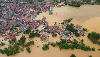
With the flooding situation from Hanoi to Thai Nguyen, even the highway is flooded, the Hanoi Department of Construction is surveying non-flooded routes to have a plan to guide traffic from a distance and will update the situation as soon as there is a plan.
The Department of Construction updated the flooding situation in Trung Gia and Soc Son areas. Some flooded routes, water levels continue to remain high and have not receded to this point.
The road management unit is currently continuing to coordinate with relevant units to place warnings and arrange traffic guides at sections of roads where vehicles cannot pass.
On National Highway 3: Flooding 0.5->1.0m at Km28, Km29.
Road 35: Flooded 0.5-1.3m at locations Km0+300-Km0+700 (Tu Tao bridge), Km2-Km2+500.
Road 16: Flooded 0.5-1m Km2+100-Km2+400.
Hong Ky - Bac Son Road through Cau Chien Bridge: Flooded 0.8-1.3m. Road 401: Flooded ~0.5m due to overflowing river water. Motor vehicles have difficulty accessing these two routes.
Source: https://baohaiphong.vn/cao-toc-thai-nguyen-ha-noi-ngap-sau-luu-y-lo-trinh-di-chuyen-523117.html


![[Photo] Ho Chi Minh City is brilliant with flags and flowers on the eve of the 1st Party Congress, term 2025-2030](https://vphoto.vietnam.vn/thumb/1200x675/vietnam/resource/IMAGE/2025/10/10/1760102923219_ndo_br_thiet-ke-chua-co-ten-43-png.webp)
![[Photo] Opening of the World Cultural Festival in Hanoi](https://vphoto.vietnam.vn/thumb/1200x675/vietnam/resource/IMAGE/2025/10/10/1760113426728_ndo_br_lehoi-khaimac-jpg.webp)
![[Photo] Unique Phu Gia horse hat weaving craft](https://vphoto.vietnam.vn/thumb/1200x675/vietnam/resource/IMAGE/2025/10/10/1760084018320_ndo_br_01-jpg.webp)


Comment (0)