
Talking about the topic of doing science and the process of manufacturing unmanned aerial vehicles, MSc. Luu Hai Au (born in 1976), Director of the Center for Geodesy and Cartography (Institute of Geodesy and Cartography - Ministry of Natural Resources and Environment ), sometimes choked up because of the difficulties and choices he had gone through.
.") |
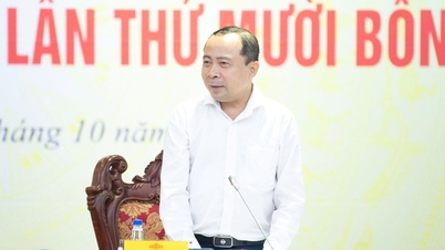
MSc. Luu Hai Au, Director of the Center for Geodesy and Cartography (Institute of Geodesy and Cartography - Ministry of Natural Resources and Environment). |
Project listed in Vietnam Golden Book of Creativity 2023
After 3 years of implementing the research project, MSc. Luu Hai Au and his colleagues at the Center for Geodesy and Cartography have successfully integrated the IMU and GNSS equipment system to collect data using virtual reference station (VRS) technology on unmanned aerial vehicles (UAV), serving the work of creating large-scale topographic maps.
In addition, the group also has a scientific product that surpasses the registration of the topic, which is to produce many versions of specialized unmanned aerial vehicles that can fly on routes. These specialized flight systems are utilized by him and his colleagues from cheap, hand-controlled model aircraft.
The project was awarded a Certificate of Merit at the 2023 Vietnam Golden Book of Creativity Award Ceremony, an event organized by the Standing Committee of the Central Committee of the Vietnam Fatherland Front in coordination with the Vietnam Union of Science and Technology Associations and the Ministry of Science and Technology .
MSc. Luu Hai Au said that field surveying (mapping done outdoors) is very dangerous, difficult, and expensive, especially in mountainous and island areas. To overcome this, since 2012, ultra-light unmanned aerial vehicles have been effectively applied by some military mapping units. However, imported products are very expensive.
In 2015, realizing the superiority of applying drones for surveying and mapping, with the support of his parents, the young man from Thai Binh bought a specialized ultra-light drone from Switzerland for 500 million VND (at that time there was no civil mapping unit imported). After a period of operation, he found that the biggest disadvantage of the system was that before flying to take pictures, there had to be teams to build and measure photo control markers in the survey area and create a map. That greatly reduced the meaning of the UAV system.
The problem for the group was to research the optimal solution for the accuracy of positioning equipment for imported UAV systems. When they started the research, they found that foreign specialized equipment was all closed (black box), unable to be improved. The research team had to improve and convert cheap model aircraft (the fuselage of the aircraft was taken from a model aircraft, the rigid wing type, only took off and landed on the runway), controlled by hand, into a specialized aircraft operating according to a pre-set itinerary. At the same time, they improved the fixed-wing aircraft, which needed a runway to take off and land, into a vertical take-off and landing fixed-wing aircraft (taking off and landing at any position).
“This project has received a certificate of merit from the Vietnam Golden Book of Creativity 2023. This is a joy, pride and also a great source of encouragement for me and my colleagues,” shared MSc. Au.
 |
MSc. Luu Hai Au and members implemented the topic. |
Replacing humans, moving towards complete automation
MSc. Luu Hai Au said that unmanned aerial vehicles have many advantages. The first advantage is that they can overcome the need for humans to go directly to the place to collect data and measure maps, especially in high mountains, deep seas, and polluted areas.
“Building software that integrates coordinates, altitudes, and rotation angles of the global navigation satellite system (GNSS-IMU) with the image center on the UAV to fully automate the work of creating large-scale topographic maps from UAV images has helped reduce the work of measuring and controlling field images, which is very difficult and costly,” said MSc. Luu Hai Au.
Another advantage, according to the author, is that the product cost is less than 100 million VND (up to 90% lower than equipment purchased from abroad). The reason is that the unmanned equipment and integrated software, processing sensor data, can be produced by themselves, thus reducing costs.
Previously, drones purchased from abroad were very expensive, and when repairs were needed, they had to be sent to the manufacturer, which was costly and inconvenient. The drones of Master Au and his colleagues, manufactured domestically, can be repaired immediately if problems arise.
In addition, when landing on the belly, after about 30 photographic flights, the skin and sensors have to be replaced, which is very expensive. The vertical landing cut has overcome this.
Most importantly, the process has been field tested and produced into real products, without the need for a pilot production project.
Currently, there are about 10 different versions. Of which, the largest version is a plane with a wingspan of nearly 3 meters, a flight time of 3 hours. It once flew over the wetlands of Dong Thap Muoi, Mekong Delta. One flight took photos and mapped 1,500 hectares.
 |
Master Luu Hai Au's success in science has a great contribution from his mother. |
To do science, you have to "burn"
After graduating from the University of Mining and Geology, majoring in Geodesy, Luu Hai Au was invited to work at a foreign Geological Federation with a salary of about 4 million VND/month. Meanwhile, the salary at the Institute of Geodesy and Cartography is 400,000 VND/month. But in the end, he chose to return to the Institute.
Recalling this period, Master Au could not hide his emotion. That choice had a great impact from his family. His parents were both officials working in state agencies, understanding the hardships and difficulties of scientists, but still encouraged their son to pursue his dream. His parents said, as soon as he graduated, instead of earning money, he should earn knowledge and science.
“Researching scientific products before registering a topic is sometimes very risky. I hope the new generation will have better research conditions. However, scientists themselves must “fire up”. Because if we do not have potential, do not have projects, ideas, and are not “risky”, it will be difficult to get investment”, Master Au stated his opinion.
The drones of MSc. Luu Hai Au and his research team are being widely used in Surveying and Mapping units inside and outside the Natural Resources and Environment sector. The products serve the measurement and mapping of wetlands, a project of the Ministry of Natural Resources and Environment.
The product serves the survey, measurement and inventory of Formosa factory (2017), a project of the Ministry of Construction. It is used in surveying, measuring and creating large-scale topographic maps, serving the design and construction of the North-South and East-West expressways of the Ministry of Transport and many related industries.
Source
![[Photo] Opening of the World Cultural Festival in Hanoi](https://vphoto.vietnam.vn/thumb/1200x675/vietnam/resource/IMAGE/2025/10/10/1760113426728_ndo_br_lehoi-khaimac-jpg.webp)


![[Photo] Ho Chi Minh City is brilliant with flags and flowers on the eve of the 1st Party Congress, term 2025-2030](https://vphoto.vietnam.vn/thumb/1200x675/vietnam/resource/IMAGE/2025/10/10/1760102923219_ndo_br_thiet-ke-chua-co-ten-43-png.webp)
![[Photo] General Secretary attends the parade to celebrate the 80th anniversary of the founding of the Korean Workers' Party](https://vphoto.vietnam.vn/thumb/1200x675/vietnam/resource/IMAGE/2025/10/11/1760150039564_vna-potal-tong-bi-thu-du-le-duyet-binh-ky-niem-80-nam-thanh-lap-dang-lao-dong-trieu-tien-8331994-jpg.webp)


Comment (0)