
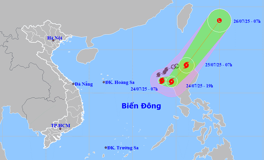
Forecasts indicate that by 7:00 AM on July 25th, the center of Typhoon No. 4 will be located at approximately 16.3 degrees North latitude and 119.5 degrees East longitude, with maximum wind speeds of level 9-10, gusting to level 12. The typhoon will change direction, moving eastward and then northeastward.
Typhoon No. 4 is unlikely to affect the mainland and coastal areas of Vietnam, but the eastern part of the North East Sea will experience strong winds of force 7-8, with winds near the center of the typhoon reaching force 9-10, gusting to force 12; sea waves will be 4-6 meters high, and the sea will be very rough.
In addition, due to the influence of the tropical convergence zone with its axis passing through the northern part of the South China Sea, connected to typhoon number 4, on July 24th, the Gulf of Tonkin and the central area of the South China Sea (including the Hoang Sa special administrative region) will experience showers and thunderstorms, with the possibility of tornadoes and strong gusts of wind during the thunderstorms.
On the night of July 24th, the sea area from southern Quang Tri to Quang Ngai experienced showers and thunderstorms.
On July 25th, both day and night, the sea area from Khanh Hoa to Lam Dong and the central part of the East Sea will experience strong southwest winds of force 6, gusting to force 7-8; sea waves will be 2-4m high, and the sea will be rough.
On land, during the afternoon and night of July 24th, the Central Highlands and the southeastern region of Vietnam will experience showers and thunderstorms, with localized heavy rain (rainfall amounts of 15-30mm, with some areas exceeding 80mm).
There is a risk of localized heavy rainfall from July 24th to 25th, with precipitation exceeding 100mm in 3 hours. During thunderstorms, tornadoes, lightning, hail, and strong gusts of wind may occur.
To proactively respond to Typhoon No. 4 in the East Sea and thunderstorms, tornadoes, and lightning on land, the Da Nang City Steering Committee for Disaster Prevention, Search and Rescue, and Civil Defense has just issued a directive requesting the City Military Command, the City Border Guard Command, and the Department of Agriculture and Environment to direct their subordinate units and the Da Nang Coastal Information Station, as well as coastal localities, to promptly inform owners of vessels and boats still operating at sea about the typhoon so that they can proactively take precautions, evacuate, or avoid moving into dangerous areas.
The City Border Guard Command proactively manages vessels going out to sea and organizes vessel counts.
Armed forces units, departments, agencies, localities, and relevant units should closely monitor the developments of the tropical depression and daily weather bulletins, warnings of thunderstorms, tornadoes, lightning, etc., to proactively handle any potential situations.
Source: https://baodanang.vn/chu-dong-theo-doi-ung-pho-bao-so-4-tren-bien-dong-va-dong-loc-set-tren-dat-lien-3297731.html


![[Photo] Prime Minister Pham Minh Chinh presides over a meeting on private sector economic development.](/_next/image?url=https%3A%2F%2Fvphoto.vietnam.vn%2Fthumb%2F1200x675%2Fvietnam%2Fresource%2FIMAGE%2F2025%2F12%2F20%2F1766237501876_thiet-ke-chua-co-ten-40-png.webp&w=3840&q=75)


Comment (0)