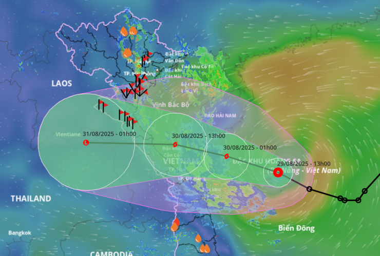
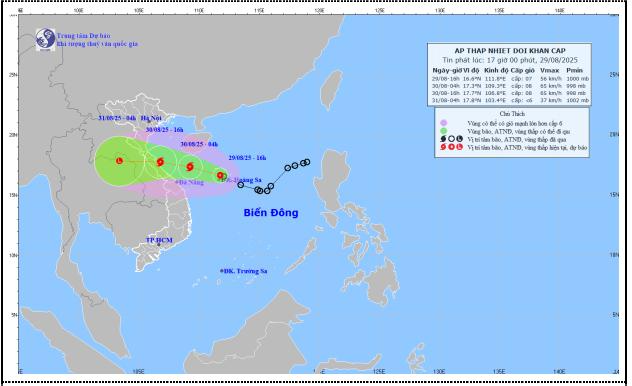
According to the Hai Phong City Hydrometeorological Station, at 4:00 p.m. on August 29, the center of the tropical depression was at about 16.6 degrees north latitude;
111.8 degrees east longitude in the Hoang Sa special zone, about 590 km east-southeast of the northern Quang Tri area; about 450 km east of Hue city. The strongest wind near the center of the tropical depression is level 7 (50-61 km/h), gusting to level 9. Moving northwest at a speed of 20-25 km/h.
At 1:00 p.m. on August 30, the storm center was located at about 17.7 degrees north latitude; 107.5 degrees east longitude on the sea from Nghe An to Hue, the strongest wind near the storm center was level 8, gusting to level 10. Natural disaster risk level Level 3.
Due to the impact of the tropical depression/storm, the Northern Delta region has widespread rain of 70-150 mm, locally very heavy rain of over 300 mm. To proactively respond to the tropical depression/storm and heavy rain, the risk of floods, landslides, inundation, ensuring the safety of life and property of the people and the state, in the coming days, the Chairman of the City People's Committee requests the Chairmen of the People's Committees of communes, wards, special zones and heads of departments, branches, agencies, and units to continue to urgently implement the direction of the City People's Committee in Official Dispatch No. 8180/VP-TL dated August 29, 2025 on proactively responding to heavy rain, floods, inundation, flash floods, and landslides.
Absolutely do not be negligent or subjective, prepare the best conditions to proactively prevent, combat and overcome the consequences caused by tropical depressions/storms, floods, and heavy rains; especially be on guard against thunderstorms, tornadoes, and lightning that can cause damage before heavy rains.
Regularly monitor and update developments of tropical depressions/storms and heavy rains to proactively review, develop and implement prevention plans and scenarios; minimize damage.
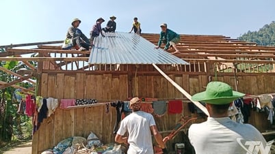
Direct and guide the implementation of measures to protect houses, warehouses, public works, infrastructure, protect production, especially agricultural and aquatic production, limit damage caused by tropical depressions/storms, heavy rains, and floods. Prepare forces and means for rescue when required.
Strengthen information, propaganda and mobilization work for people to implement measures to prevent tropical depressions/storms, heavy rains, floods, and protect the safety of people and property.
Organize inspections, reviews, and take measures to ensure the safety of telecommunications systems and power grid systems to maintain operations without interruption before, during, and after tropical depressions/storms and heavy rain.
Focus on calculating damage, proactively overcoming consequences (if any), ensuring hygiene, environment and landscape immediately after the storm has passed to immediately restore daily life, production and business activities.
People's Committees of communes, wards, coastal and riverside special zones: Organize the counting and notification of vehicle owners, captains of ships and boats operating at sea about the location, direction of movement and developments of tropical depressions/storms to proactively avoid, return to safe shelters, escape or not move into dangerous areas; maintain communication to promptly handle bad situations that may occur. Regularly monitor and continuously update warning bulletins about storms and tornadoes to promptly direct, inform and request water transport vehicles (especially tourist boats), coastal and riverside tourists to know and avoid. Proactively implement work to ensure safety of people, vehicles and property, especially for tourist destinations, aquaculture, fishing and constructions at sea, on islands, coastal areas and riverside. Review and proactively evacuate people from dangerous areas, unsafe areas, areas at risk of deep flooding, river mouths, and coastal areas to ensure safety of people's lives and limit damage to people's property when natural disasters occur.
For other localities: Proactively deploy measures to prevent and combat tropical depressions/storms, heavy rains, and floods in accordance with the storm's developments and local characteristics.
Localities with mountainous and hilly areas urgently review and notify each household living in areas at risk of landslides and flash floods to check around their residence to promptly detect unusual and dangerous signs so that they can proactively evacuate from dangerous areas. Prepare measures to drain water, prevent flooding, and protect agricultural production when heavy rains occur.
The Department of Construction closely coordinates with localities to ensure safety of waterway and road traffic; strictly controls the operation of water transport vehicles. Actively monitor and issue notices prohibiting and stopping inland waterway transport, river bridges, ferry terminals and boats according to its authority. Direct the implementation of measures to be ready to drain water in urban areas; arrange permanent positions at deep flooded areas, open drainage manhole covers to warn and ensure safety for people and vehicles; prepare human resources and vehicles to immediately fix incidents on main traffic routes to ensure smooth traffic. Review and inspect old and weak apartment buildings; based on the developments of tropical depressions/storms and heavy rains, proactively inform localities to organize the evacuation of people to ensure safety.
The City Military Command directed the Border Guard Command to count and notify owners of vehicles operating at sea by all means to urgently move to safe shelters; strictly manage the activities of fishing boats, tourist boats, and transport ships; organize safe anchoring of boats; maintain regular contact with owners of vehicles to promptly handle any bad situations that may arise.
The Director of the Department of Agriculture and Environment (Deputy Head of the City Civil Defense Command) regularly and closely monitors weather developments; based on the developments of tropical depressions/storms and heavy rains, proactively develops and issues specific response plans for units and localities to organize prevention and control work. Based on the developments of tropical depressions/storms, proactively coordinate with the Department of Construction, the City Military Command, and relevant localities to issue documents prohibiting activities on river mouths and seas to prevent and minimize damage.
Direct the implementation of response plans, ensure the safety of dykes and reservoirs that are full of water; direct the deployment of standing forces to operate and regulate reservoirs and irrigation systems to prevent flooding; implement measures to protect agricultural production and be ready to handle possible situations. Proactively update and advise the City Civil Defense Command and the City People's Committee on response instructions.
Forecast of the impact of tropical depression on Hai Phong city:
From tonight (August 29), the northern Gulf of Tonkin (including Bach Long Vi special zone) will have winds gradually increasing to level 6, sometimes level 7, gusting to level 8; waves 2-3 m high, rough seas. Southern Gulf of Tonkin: Winds gradually increasing to level 6-7, near the storm center level 8, gusting to level 10. Waves 2-4 m high, near the storm center 3-5 m, rough seas.
From early tomorrow morning (August 30), Hai Phong sea area (including Cat Hai special zone, Cat Ba sea area, Lan Ha bay and Hon Dau-Do Son sea area) will have wind level 4-5, sometimes level 6.
Wind on land: The coastal area of Hai Phong (including the wards of Do Son, Nam Do Son, Duong Kinh, Dong Hai, Hai An, Nam Trieu and the communes of Kien Hai, Hung Thang, Chan Hung) has winds of level 4-5. Wards/communes located further inland have winds of level 3-4.
All vessels, anchorages, aquaculture areas, sea dykes and other activities in the above sea areas are at very high risk of being affected by storms, whirlwinds, strong winds and large waves. Strong winds can break trees, damage houses, traffic works and infrastructure, endangering human lives. The risk level of natural disasters due to strong winds at sea is Level 2.
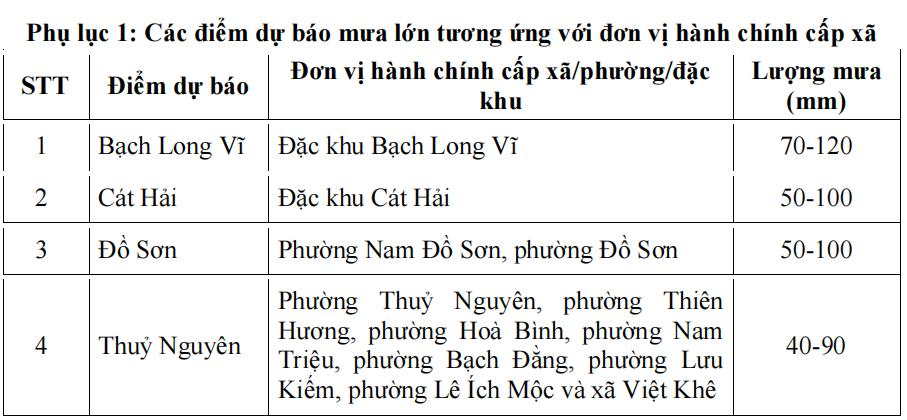
Tonight and tomorrow (August 30), the northern Gulf of Tonkin (including Bach Long Vi special zone) will have heavy to very heavy rain and thunderstorms. Rainfall from 70-120 mm. The Hai Phong sea (including Cat Hai special zone, Cat Ba sea, Lan Ha Bay and Hon Dau - Do Son sea) will have moderate rain, heavy rain and thunderstorms. Rainfall from 50 - 100 mm.
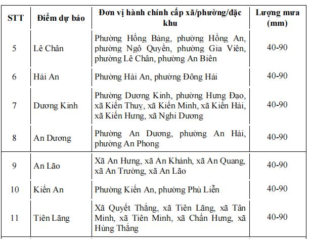
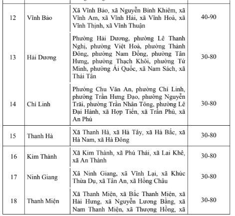
Wards/communes in the Northeast and Southeast of the city (including forecast locations: Thuy Nguyen, Le Chan, Hai An, Duong Kinh, An Duong, An Lao, Kien An, Tien Lang, Vinh Bao) have moderate rain, heavy rain and thunderstorms. Rainfall from 40 - 90 mm.
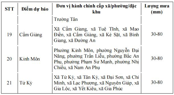
Wards/communes in the northwest and southwest of the city (including forecast locations: Hai Duong, Chi Linh, Thanh Ha, Kim Thanh, Ninh Giang, Thanh Mien, Cam Giang, Kinh Mon and Tu Ky) have moderate rain, heavy rain and thunderstorms. Rainfall from 30-80 mm.
Thunderstorms and heavy rains overload urban drainage systems, causing flooding in residential areas, traffic jams due to flooded roads and reduced visibility when driving, causing slippery roads and traffic accidents. Thunderstorms can be accompanied by tornadoes, lightning and strong gusts of wind that can break trees, damage houses, traffic works and infrastructure.
Heavy rain in a short period of time can cause landslides in mountainous areas, flooding urban areas and low-lying areas. Warning level of natural disaster risk due to heavy rain Level 1.
Source: https://baohaiphong.vn/chu-cich-ubnd-thanh-pho-hai-phong-yeu-cau-khan-truong-phong-chong-ap-thap-nhet-doi-va-mua-lon-519484.html



![[Photo] General Secretary To Lam receives Chairman of the National People's Congress of China Zhao Leji](https://vphoto.vietnam.vn/thumb/1200x675/vietnam/resource/IMAGE/2025/8/31/5af9b8d4ba2143348afe1c7ce6b7fa04)
![[Photo] First Secretary and President of Cuba begins State visit to Vietnam](https://vphoto.vietnam.vn/thumb/1200x675/vietnam/resource/IMAGE/2025/8/31/f169c1546ec74be7bf8ccf6801ee0c55)

![[Photo] Chairman of the National People's Congress of China Zhao Leji begins official visit to Vietnam](https://vphoto.vietnam.vn/thumb/1200x675/vietnam/resource/IMAGE/2025/8/31/fcfa5a4c54b245499a7992f9c6bf993a)




























Comment (0)