
Typhoon Wipha will become typhoon No. 3 after entering the East Sea and may become stronger, with rainfall in some places reaching over 500 mm. However, the storm is not expected to cause as much damage as Typhoon Yagi in September 2024.
 |
| The Deputy Minister of Agriculture and Rural Development chaired a meeting with representatives of ministries and sectors to develop a response plan for storm Wipha. It is forecast that storm Wipha will enter the East Sea on the night of July 20 and early morning of July 21. |
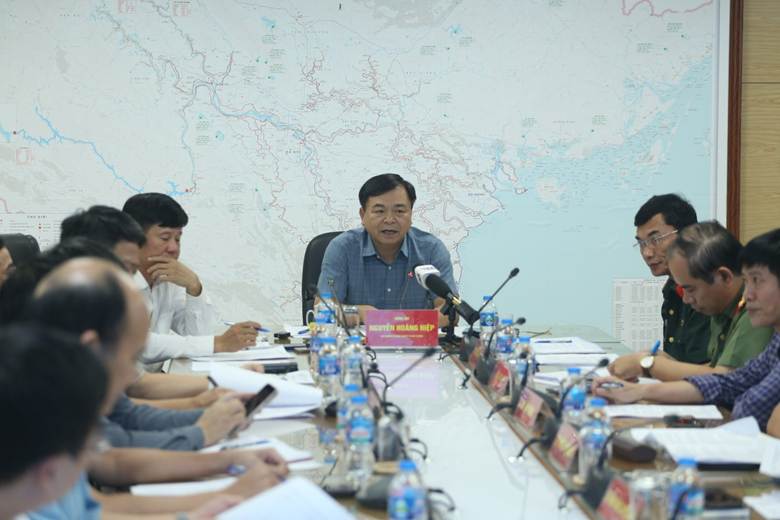
On the afternoon of July 18, the National Steering Committee for Natural Disaster Prevention and Control held a meeting to provide information and organize responses to storm Wipha.
At the meeting, Mr. Mai Van Khiem - Director of the National Center for Hydro-Meteorological Forecasting said that tomorrow morning (July 19), storm Wipha will enter the East Sea - becoming storm number 3. It is forecasted that on the night of July 20 and early morning of July 21, the storm with level 12 gusts of level 15 will move west of Hainan Island (China).
Currently, storm Wipha is moving at a speed of 30km/h. According to Mr. Khiem, with its current fast speed, the possibility of the storm making landfall is very high.
Current status of the storm at 1:00 p.m. on July 19: The center of the storm is located at approximately 18.3 degrees North latitude; 123.5 degrees East longitude, in the sea northeast of Luzon Island (Philippines). The strongest winds reach level 8-9 (62-88 km/h), with gusts up to level 11 (103-117 km/h) near the center of the storm.
"With the current environmental conditions in the East Sea, it is forecasted that storm Wipha will increase in intensity when entering the East Sea. There is a high possibility that it will make landfall in Vietnam, affecting Quang Ninh - Nghe An ," said Mr. Khiem.
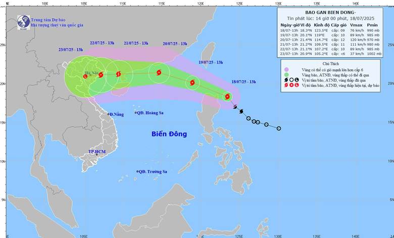 |
| Latest storm news update: Storm WIPHA is currently active in the sea northeast of Luzon Island (Philippines) and continues to move northwest at a fast speed of about 30km/h, heading straight into the Gulf of Tonkin of our country. Photo: NCHMF |
Regarding rainfall, Typhoon Wipha is expected to cause heavy rains over a wide area of the Northern and North Central regions (from Quang Ninh to Nghe An). Rainfall distribution will depend on the direction of the storm. Rainfall is forecast to be from 200 - 300 mm; some places over 500 mm.
Mr. Khiem said that it will be until noon on Sunday (July 20) that the specific rainfall of storm Wipha can be assessed.
According to Mr. Khiem, after storm Wipha makes landfall, another storm will appear and move north, creating a low trough, causing prolonged rain on July 24-25.
"Current forecast models are not yet consistent in terms of the intensity, rainfall, and direction of storm Wipha," Mr. Khiem informed.
Mr. Khiem noted that storm Wipha will tend to move north, less likely to cause damage like storm No. 3 in September 2024. However, we still have to maintain a mindset to face a strong storm.
Regarding ships and aquaculture at sea, a representative of the Department of Fisheries and Fisheries Surveillance said that through counting, from Quang Ninh to Nghe An, there are nearly 15,000 ships fishing and exploiting aquatic products at sea. Up to now, through checking, there are 23 anchorage areas and can organize anchorage for about 17,000 ships when the storm comes.
 |
| Mr. Mai Van Khiem - Director of the National Center for Hydro-Meteorological Forecasting predicted that storm Wipha will be stronger when entering the East Sea. |
Also through review, currently from Quang Ninh - Nghe An, there are 150,000 hectares of aquaculture, with 20,000 cages and rafts. To avoid damage like that caused by Typhoon Yagi, from now until Sunday (July 20), depending on the path and level of the storm, the Department of Fisheries and Fisheries Control will direct, harvest, and sell fish and shrimp if there is enough weight.
With the current path and speed of storm Wipha, Deputy Minister of Agriculture and Environment Nguyen Hoang Hiep said that the most worrying thing is that this storm has the "shadow" of storm No. 3 in September 2024. Therefore, we must not be subjective, we must be proactive in responding to a strong storm.
This is the peak tourist season, aquaculture activities at sea and rice are tillering, citrus trees are bearing fruit... if a storm comes, it will cause great damage, so we must calculate and carefully prepare response plans.
Regarding reservoirs, Deputy Minister Hiep expressed concern that all reservoirs currently have a water capacity of 80 - 85%. Thus, when a storm makes landfall, causing heavy rain, it will cause great pressure. Especially for reservoirs without spillways, if not carefully calculated, it will be very dangerous for the reservoir system.
Deputy Minister Nguyen Hoang Hiep said that if this storm makes landfall in our country, it will be right at the time when the new two-tier local government model comes into operation. Therefore, this is also a time for localities to organize on-call duty, organize and deploy tasks and solutions to respond to natural disasters.
According to Minh Ngoc/Dan Viet
Source: https://baovinhlong.com.vn/thoi-su/202507/chuyen-gia-canh-bao-khi-vao-bien-dong-thanh-bao-so-3-bao-wipha-con-manh-hon-gay-mua-tren-dat-lien-tren-500mm-4303c68/


![[Video] More than 100 universities announce tuition fees for the 2025–2026 academic year](https://vphoto.vietnam.vn/thumb/1200x675/vietnam/resource/IMAGE/2025/7/18/7eacdc721552429494cf919b3a65b42e)


![[Infographic] In 2025, 47 products will achieve national OCOP](https://vphoto.vietnam.vn/thumb/402x226/vietnam/resource/IMAGE/2025/7/16/5d672398b0744db3ab920e05db8e5b7d)


Comment (0)