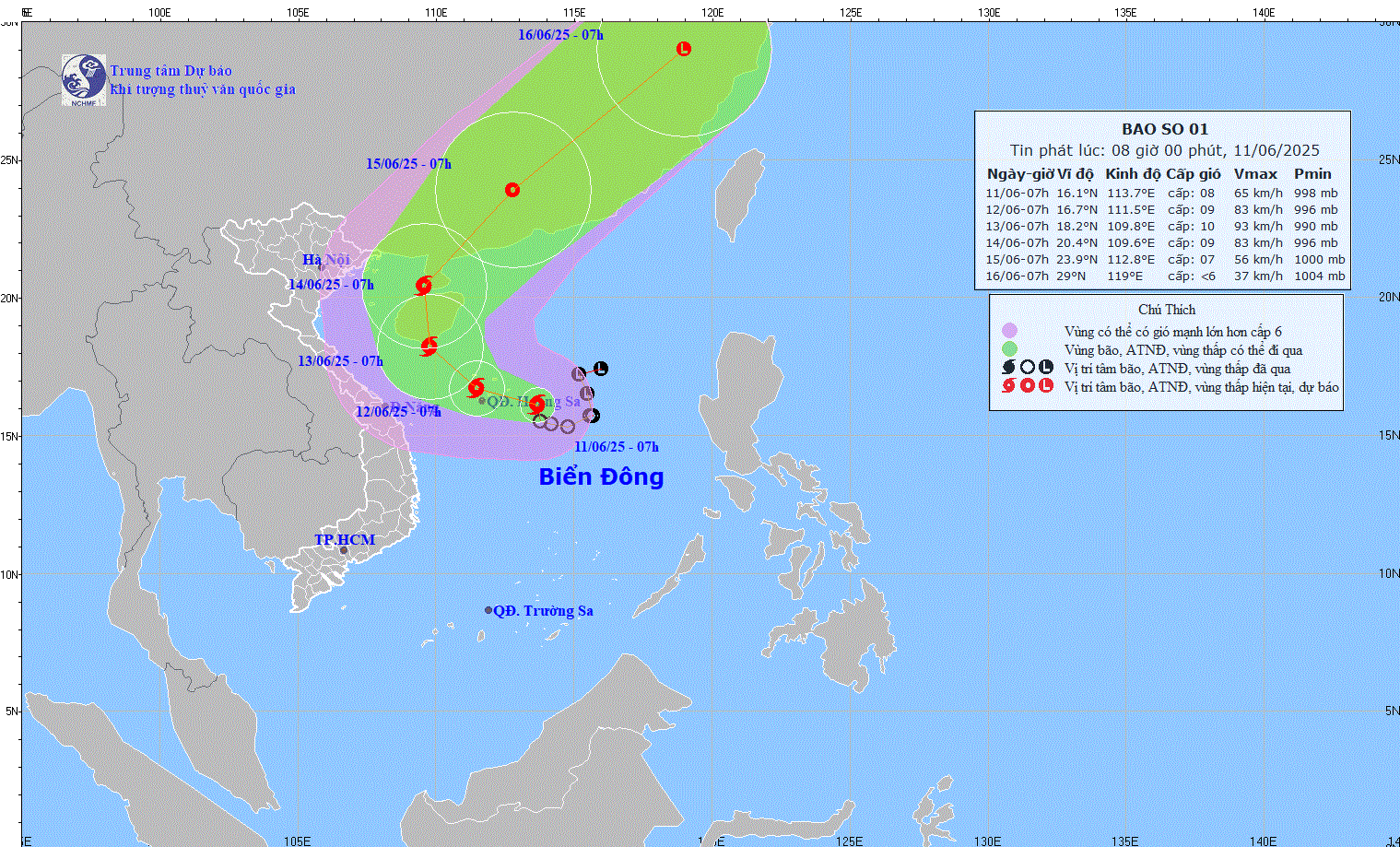
This morning, June 11, the National Center for Hydro-Meteorological Forecasting informed that the tropical depression in the sea east of Hoang Sa archipelago has strengthened into a storm, becoming the number 1 storm in the East Sea in 2025. The storm, internationally named WUTIP, is also the first storm to appear in the Northwest Pacific region this year.
At 7:00 a.m., the storm center was at about 16.1 degrees North latitude - 113.7 degrees East longitude, about 220 km East Southeast of Hoang Sa archipelago. The strongest wind near the storm center reached level 8 (62-74 km/h), gusting to level 10. The storm moved slowly in the West Northwest direction at a speed of about 5-10 km/h and is likely to strengthen in the next 1-2 days.
It is forecasted that in the next 24-72 hours, the storm will move northwest and then change direction to the north. By the morning of June 13, the storm will approach the south of Hainan Island (China) with the strongest intensity reaching level 10, gusting to level 13. By the morning of June 14, when approaching Leizhou Peninsula (China), the storm will tend to weaken gradually.
The National Center for Hydro-Meteorological Forecasting warns that the northern East Sea, including the Hoang Sa archipelago, is experiencing strong winds of level 6-7, near the storm center at level 8-9, gusting to level 11. Waves are 3-5m high, with very rough seas. The central and southern East Sea, including Truong Sa, is experiencing strong southwest winds of level 6, sometimes at level 7, gusting to level 8-9, with waves 2-4m high.
Ships operating in the danger zone are advised to closely monitor the storm's developments, beware of strong winds, large waves and whirlwinds at sea. The disaster risk level is warned at level 3 for the North East Sea and offshore waters from Quang Tri to Quang Ngai .
Source: https://www.sggp.org.vn/con-bao-dau-tien-tren-bien-dong-nam-2025-co-the-manh-cap-10-post798958.html


Comment (0)