

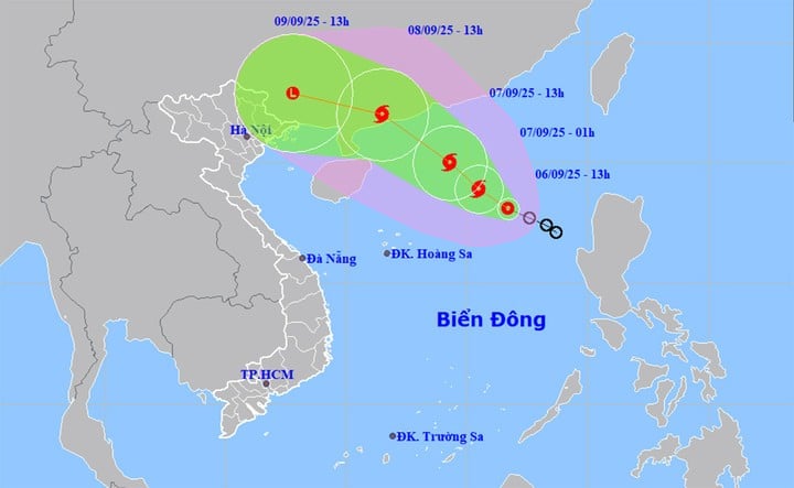
The National Center for Hydro-Meteorological Forecasting said that at 1:00 p.m. on September 6, the center of the storm was tropical depression on the eastern sea of the North East Sea. The strongest wind near the center of the tropical depression is level 7 (50-61km/h), gusting to level 9, moving northwest at a speed of 15km/h.
Conditions for the tropical depression are quite favorable for development, with sea surface temperatures in the northern part of the East Sea, above 15 degrees North latitude, currently at 29-30°C.
In the area of tropical depression activity, wind shear is also small, plus the southwest wind in the South is relatively strong.
Therefore, the possibility is that this afternoon and tonight, the tropical depression will strengthen into a storm, with a probability of up to 70-80%. If it strengthens into a storm, this will be the 16th storm in the Northwest Pacific region and the storm storm no. 7 operating in the East Sea, according to the international name list is Tapah.
According to the meteorological agency, this tropical depression/storm formed in the northern part of the East Sea, while the subtropical high pressure tongue, the main shape that determines the path and direction of movement of tropical depressions/storms, tends to weaken.
"This tropical depression/storm is located in the western part of the subtropical high pressure tongue. According to the path trend, the storm will mainly move in the northwest direction. The possibility of the storm moving deep towards our mainland is not high. The storm may make landfall in China.
Currently, forecasts from international storm forecasting centers predict that this storm will make landfall in China's Guangdong province on September 8. When it makes landfall, the storm's intensity could reach level 10-11, gusting to level 13-14. National Center for Hydro-Meteorological Forecasting commented.
Vietnam's forecast is quite similar to international forecasts. Vietnam believes that in the evening and night of September 6, this tropical depression will strengthen into storm No. 7, with the strongest intensity when approaching the mainland coast of Guangdong province (China) reaching level 10, gusting to level 13. Landfall in China is expected to be around the morning and noon of September 8.
The meteorological agency also pointed out the difference of storm No. 7. Accordingly, this is a storm formed on the tropical convergence zone, the storm's formation location is in the northern region of the East Sea. However, the storm's formation point is quite high, in the north of the northern region of the East Sea, the direction of movement is much more to the north. The period when storms usually affect the North and begin to move south, affecting the Central region, but this storm made landfall in China.
"Although it makes landfall in China, after making landfall, storm No. 7 will quickly weaken into a low-pressure area, then drift westward, towards our country. It is likely that from the afternoon and night of September 9-11, the post-storm circulation of storm No. 7 will cause widespread heavy rain in the North, focusing on the midlands and mountainous areas of the Northeast." The National Center for Hydro-Meteorological Forecasting added.
Source: https://baolangson.vn/diem-khac-biet-cua-bao-so-7-tapah-sap-hinh-thanh-mien-bac-don-mua-lon-trong-3-ngay-5058120.html


![[Photo] Thac Ba Lake: Towards an international-class tourism, resort and cultural center by 2040](https://vphoto.vietnam.vn/thumb/1200x675/vietnam/resource/IMAGE/2025/9/12/0940443efe0a427b88707caadba1cc41)

![[Photo] General Secretary To Lam attends the launching ceremony of the website of the Communist Party of Vietnam - 14th National Congress](https://vphoto.vietnam.vn/thumb/1200x675/vietnam/resource/IMAGE/2025/9/12/0d4fce7dbce2409cb3c03c21fdf3c3b5)
![[Photo] Launching Ceremony of the Specialized Electronic Information Page of the Communist Party of Vietnam - 14th Congress](https://vphoto.vietnam.vn/thumb/1200x675/vietnam/resource/IMAGE/2025/9/12/4c1b894be2ea4e3daccfd8c038b6fb46)


![[Photo] Where the history of resistance comes alive with modern technology at "95 years of the Party Flag lighting the way"](https://vphoto.vietnam.vn/thumb/1200x675/vietnam/resource/IMAGE/2025/9/12/81c1276f52b849c8b16e2d01dd1c85e4)


Comment (0)