
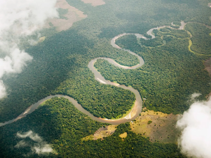
The Congo River - the deepest river in the world and the second longest in Africa - has just been re-measured and found to be about 1,000km longer than previous documents - Photo: CN TRAVELER
According to Xinhua News Agency on May 21, a Chinese scientist used satellite remote sensing technology to accurately determine the source of the Congo River - the world's deepest river and the second longest in Africa. Accordingly, the actual length was re-determined to be 5,260km, much longer than previous estimates.
Mr. Liu Shaochuang - the performer and researcher of the Institute of Spatial Information Research, Chinese Academy of Sciences - said that he used remote sensing images from satellites and conducted two field surveys in the upstream area to accurately determine the coordinates of the river source.
The results showed that the origin point was located at longitude 31.22 degrees East and latitude 9.19 degrees South, at an altitude of 1,771m above sea level.
Based on the newly determined source location, the Congo River's length reaches 5,260km, about 1,000km longer than previous estimates, which ranged from 4,320 to 4,700km.
The Congo River has long been known as the deepest river in the world - more than 220m deep - with abundant water reserves, and is the second longest river in Africa after the Nile.
Since the 19th century, many explorers and geographers have sought to approach and determine the exact origin of this river. However, due to the rugged terrain with many rapids, and strong and complex currents, research and accurate determination is still a big challenge.
Mr. Liu said that determining the length of a river depends largely on how the source is identified, the data set used, and the measurement method. Previously, locating river sources often relied on outdated traditional techniques or folk legends, leading to inconsistent data.
Now with modern technology, especially satellite remote sensing, scientists have been able to standardize data on river sources and lengths thanks to the ability to cover the entire basin. Therefore, Mr. Luu believes that satellite remote sensing technology is the most effective tool.
According to international principles, a river's source is defined as the farthest branch with year-round flow. Based on this criterion, Mr. Liu combined satellite technology and field surveys to re-identify the sources of more than 20 major rivers in the world, including the Yangtze, Yellow, Nile and Amazon.
Source: https://tuoitre.vn/do-lai-do-dai-song-sau-nhat-the-gioi-phat-hien-dai-hon-1-000km-so-voi-truoc-2025052120553051.htm


![[Photo] Discover unique experiences at the first World Cultural Festival](https://vphoto.vietnam.vn/thumb/1200x675/vietnam/resource/IMAGE/2025/10/11/1760198064937_le-hoi-van-hoa-4199-3623-jpg.webp)


![[Photo] General Secretary attends the parade to celebrate the 80th anniversary of the founding of the Korean Workers' Party](https://vphoto.vietnam.vn/thumb/1200x675/vietnam/resource/IMAGE/2025/10/11/1760150039564_vna-potal-tong-bi-thu-du-le-duyet-binh-ky-niem-80-nam-thanh-lap-dang-lao-dong-trieu-tien-8331994-jpg.webp)


Comment (0)