
Heavy rain in many areas

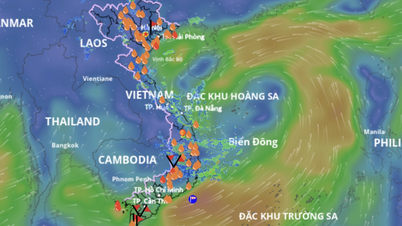
According to Deputy Head of Weather Forecast Department, National Center for Hydro-Meteorological Forecasting Vu Anh Tuan, from the night of May 22 to May 24, the Northern region is likely to experience a period of moderate rain, heavy rain and thunderstorms, locally very heavy rain with total rainfall of 70-150mm, some places over 250mm. From May 25 to May 30, there will be scattered showers and thunderstorms, locally heavy rain (rain concentrated in the evening and at night).
From the evening and night of May 23 to the night of May 24, the North Central region is likely to experience moderate to heavy rain and thunderstorms, locally very heavy rain with total rainfall of 40-100mm, some places over 150mm. Warning of the risk of heavy rain over 100mm in 3 hours, thunderstorms are likely to cause tornadoes, lightning, hail and strong gusts of wind. Warning of level 1 natural disaster risk due to heavy rain, tornadoes, lightning, hail.
Central Central region will have sunny days, hot in some places, scattered showers and thunderstorms in the afternoon and evening. South Central region will have scattered showers and thunderstorms in some places, especially in the afternoon and evening of May 22-25.
The Central Highlands and the South have scattered showers and thunderstorms, with scattered showers and thunderstorms in the afternoon and evening, and locally heavy rain in some places; from the night of June 22-25, there will be rain, moderate rain and thunderstorms, with locally heavy rain in some places.
"This is the time of changing seasons, so strong thunderstorms may appear with tornadoes, lightning, hail, and strong gusts of wind. These risks not only occur in the provinces and cities of the North but also in the South and Central Highlands. Heavy rain can cause flooding in low-lying areas, urban and industrial areas; flash floods on small rivers and streams; and landslides on steep slopes. Real-time warning information on areas at risk of flash floods and landslides is provided online on the website of the Department of Hydrometeorology at: https://luquetsatlo.nchmf.gov.vn and in separate bulletins warning of flash floods and landslides," Mr. Nguyen Anh Tuan warned.
Regarding the hot weather, Mr. Vu Anh Tuan noted that from May 21-22, the area from Thanh Hoa to Phu Yen will be hot, some places will be extremely hot with the highest temperature commonly ranging from 35-37 degrees Celsius, some places will be over 37 degrees Celsius; the lowest relative humidity is commonly 50-55%, the hot weather lasts from 12-16 hours. However, the forecast temperature in the hot weather bulletins and the actual temperature felt outdoors may differ by 2-4 degrees Celsius, or even higher depending on the conditions of the buffer surface such as concrete and asphalt. Warning, the widespread heat in the area from Thanh Hoa to Phu Yen from May 23 will tend to ease. The risk level of natural disasters due to heat is level 1.
Due to the effects of heat combined with low humidity and the southwest wind causing the foehn effect, there is a risk of explosions and fires in residential areas due to increased demand for electricity and the risk of forest fires. Heat can cause dehydration, exhaustion, and heat stroke in the human body when exposed to high temperatures for a long time. In addition, heat also directly affects the lives and production of people and the community.
To protect the health of yourself and your family during hot days, health experts recommend that people limit going out between 11am and 2pm every day. If you have to go out, wear long-sleeved and long-legged clothes and wear a hat to cover your head and face to protect your skin as much as possible.
People need to supplement enough and moderate water every day and every hour (it is best to choose types of water such as: filtered water, fruit juice, pure green vegetable juice...) to prevent heat and compensate for lost water...
Beware of flash floods and landslides in Lao Cai, Lai Chau and Ha Giang

Regarding the rain situation, according to the National Center for Hydro-Meteorological Forecasting, from 7:40 a.m. to 1:40 p.m. on May 21, Lao Cai, Lai Chau and Ha Giang provinces will continue to have rain with common rainfall such as Lao Cai and Lai Chau provinces from 10-30mm, some places over 50mm; Ha Giang province from 10-20mm, some places over 30mm. There is a risk of flash floods on small rivers and streams, landslides on steep slopes in the above provinces, especially in the districts: Sin Ho, Tam Duong, Tan Uyen, Phong Tho, Nam Nhun (Lai Chau province); Bao Thang, Bao Yen, Sa Pa town, Van Ban (Lao Cai province); Bac Quang, Hoang Su Phi, Quang Binh, Vi Xuyen, Xin Man, Bac Me (Ha Giang province). Warning level of natural disaster risk due to flash floods, landslides, land subsidence due to heavy rain or level 1 flow.
Flash floods and landslides can have very negative impacts on the environment, threaten people's lives; cause local traffic congestion, affect the movement of vehicles; destroy civil and economic works, causing damage to production and socio-economic activities.
To prevent flash floods and landslides, it is necessary to use structural and non-structural solutions.
Regarding engineering measures, it is necessary to plant and protect upstream protective forests, especially in areas that often cause flash floods, to protect the ecological environment, protect the vegetation cover, increase the water retention capacity of the basin, and limit the ability to concentrate flood flows.
Building flood control reservoirs in areas where flash floods often occur, clearing flood drainage routes, building dykes, flash flood walls, diverting flood flows, and constructing additional spillways in reservoirs.
Due to the characteristics of short and steep rivers in the Central region, to avoid blocking flood flows causing flooding, flash floods and traffic jams, it is necessary to calculate flood drainage planning for bridge and culvert systems on railway and road systems.
For non-structural measures, it is necessary to create a map of flash flood risk zones (high risk; medium risk and areas with low risk of flash floods). This map is one of the important bases for proposing flash flood prevention measures.
Land use planning restricts development in areas at high risk of flash floods. For previously unplanned residential areas, re-planning and resettlement are needed, moving people out of areas at high risk of flash floods and landslides.
Along with that, it is necessary to adjust the conditions of the basin buffer surface and flood storage areas such as implementing "agro-forestry" measures to prevent erosion, improve soil, increase crop productivity, and promote land use efficiency...
To minimize the damage caused by flash floods, for areas at high risk of flash floods, there should be specific plans for prevention such as: Building flood risk maps of flood-prone areas, evacuation plans, evacuation routes and assembly locations; selecting areas and high locations not affected by flash floods, building some solid houses to gather assets, food and people when there are flash floods; having plans to evacuate people to high areas and safe places, especially for the elderly and children; establishing rescue units to be ready to help people evacuate, search, rescue, rescue people and protect people's property during flash floods.
In addition, each person needs to grasp and use flood risk maps proficiently, master evacuation plans and be proactive in prevention.
From 6:00 p.m. on May 20 to 6:00 a.m. on May 21, there was rain in Lao Cai, Lai Chau and Ha Giang provinces, some places had moderate to heavy rain, some places had very heavy rain such as: Xuan Minh (Ha Giang) 132.8mm, Tan Lap (Ha Giang) 132.8mm; Than Thuoc (Lai Chau) 191.6mm, Nam Can (Lai Chau) 122.2mm; Nam Chay (Lao Cai) 50.4mm;...
Soil moisture models show that some areas in the above provinces are close to saturation (over 85%) or have reached saturation.
Tornadoes and strong winds at sea

According to the National Center for Hydro-Meteorological Forecasting, there are currently showers and local thunderstorms in the South China Sea.
Forecast, in the afternoon and night of May 21, the sea area from Binh Thuan to Ca Mau, Ca Mau to Kien Giang, the Gulf of Thailand, the South East Sea area (including the sea area of the region)
Truong Sa) has scattered showers and thunderstorms, with the possibility of tornadoes and strong gusts of wind at level 6-7.
All vessels operating in the above areas are at risk of being affected by tornadoes and strong gusts of wind.
According to the guidance of the Ministry of Agriculture and Environment, coastal provinces and cities affected by the storm must closely monitor warning bulletins, forecasts and developments of strong winds at sea; notify captains and owners of vehicles and vessels operating at sea to proactively prevent and have appropriate production plans, ensuring safety of people and property; maintain communication to promptly handle possible bad situations.
Source: https://baolaocai.vn/du-bao-thoi-tiet-10-ngay-nhieu-khu-vuc-co-mua-dong-cuc-bo-co-noi-mua-to-den-rat-to-post402119.html


![[Photo] National Assembly Chairman Tran Thanh Man attends the program "Returning to the source - Towards the future"](https://vphoto.vietnam.vn/thumb/1200x675/vietnam/resource/IMAGE/2025/8/16/d081d9c162ee4ed9919e723aa322a53a)


![[Photo] General Secretary attends the inauguration ceremony of the Ministry of Public Security Headquarters](https://vphoto.vietnam.vn/thumb/1200x675/vietnam/resource/IMAGE/2025/8/16/3ceec3a24ef945c18ae2b523563b749d)


Comment (0)