
 |
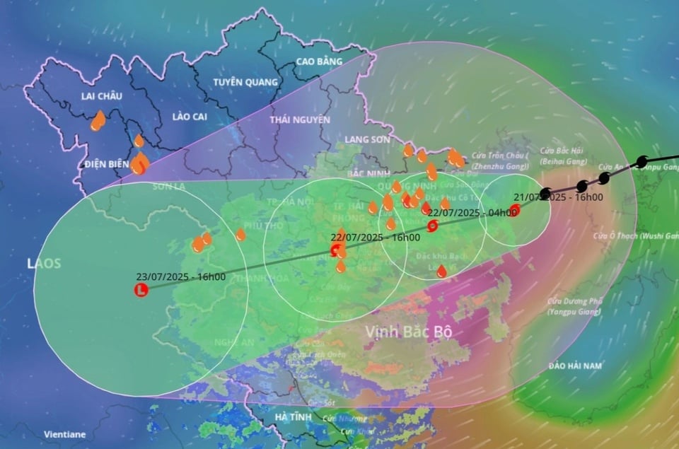
Expected path of storm Wipha. Photo: VNDMS . |
According to the National Center for Hydro-Meteorological Forecasting, the evolution of storm Wipha has changed significantly to date. At 3:00 p.m. on July 22, the storm had moved deep into the mainland in the provinces of Hung Yen - Ninh Binh. The strongest wind near the storm's center was at level 8 (62-74 km/h), gusting to level 10.
At 12 noon on July 22, Dr. Nguyen Ngoc Huy, who has 20 years of experience in researching disaster risk reduction, climate change and livelihoods, said that the storm had dissipated. Experts said that the downgrade was a good sign, but did not indicate absolute safety.
Danger after the storm
In a post at 12:20 on July 22, Mr. Huy stated that storm Wipha had weakened into a low pressure area in the border area between Thanh Hoa and Ninh Binh. However, due to the storm's circulation shifting south, Thanh Hoa and Nghe An provinces, west of Ninh Binh, continued to have heavy rain this afternoon.
Mr. Mai Van Khiem, Director of the National Center for Hydro-Meteorological Forecasting, said that the circulation of storm No. 3 is very wide. Since the evening of July 20, although it has not yet entered the Gulf of Tonkin, this area has had widespread rain. In the provinces of the Northern Delta, including the capital Hanoi , scattered rain has also been recorded due to the influence of the storm cloud edge.
Although the storm has weakened, according to records, the highest rainfall recorded in Thanh Hoa from 7pm on July 21 to 12pm on July 22 was 293mm, and on the afternoon of July 22, the total rainfall could exceed 400mm within 24 hours. Many areas in the area could exceed 500mm, with flooding recorded.
 |
Heavy rains after storms can cause major hazards. Photo: Reuters. |
Mr. Hoang Van Dai, Deputy Director of the National Center for Hydro-Meteorological Forecasting, predicted that with such continued rainfall, there is a high risk of flash floods, landslides, and localized flooding, especially in the west of Thanh Hoa and Nghe An. Currently, in these two provinces, there is heavy rain, rivers and streams are starting to form flood flows and will increase sharply.
In fact, according to a study by the University of California, the strength of a storm’s winds does not necessarily reflect the strength of the accompanying rain. In some cases, the amount of rainfall is more important than the peak winds to cause tree loss, landslides, and ecological disruption.
Therefore, even when the storm shows signs of weakening, people still need to be on guard against danger. “During this time, people should limit their movements. If necessary, they should avoid going near rivers and streams and through spillways because the flood is likely to come quickly, and it may be too late to respond,” said Mr. Dai.
The erratic storm
Typhoon Wipha is considered not as large as Yagi, the largest storm to make landfall in Vietnam in the past 70 years. However, this storm still has many notable differences, such as a wider circulation, heavy rainfall and longer duration.
Although it has made landfall, some localities such as Hai Phong, Hai Duong, Hung Yen (old), and Hanoi have recorded intermittent rainfall, and sunny weather can be seen. Dr. Nguyen Ngoc Huy explained that because the storm continues to maintain its central asymmetry and shift to the South, the cloud disk in the Northwest is thin.
In contrast to the above areas, storm clouds are covering and will cause more rain in Ninh Binh, Thanh Hoa, Nghe An and part of Ha Tinh. Particularly, the coastal areas of Hung Yen, Ninh Binh and Thanh Hoa provinces will have very heavy rain.
 |
Rainfall distribution map from storm No. 3 in the past 24 hours. Photo: NCHMF. |
Hurricanes have been taking erratic paths lately, meandering and hovering for days at a time. A study published in the journal Nature found that hurricanes around the world have slowed significantly over the past 65 years.
This phenomenon is accompanied by heavy rainfall and rising sea levels. Cases such as Harvey (2017) or Doksuri (2023) both recorded record damage not due to wind but because of persistent rain.
According to the Hydrometeorological Forecasting Center, although the offshore phase moved quickly (20-25km/h), Typhoon Wipha slowed down to only 10-15km/h when approaching land. Mr. Khiem said that although the current trajectory of the storm is consistent with the official forecast, the center still does not rule out a bad scenario.
Before the typhoon hit Hong Kong, Lam Chiu-ying, former director of the Hong Kong Meteorological Department, said luck played a big part in mitigating the damage caused by Wipha. “If the typhoon had been off course by just 10–20km, the extent of the devastation could have been completely different,” he said.
Source: https://znews.vn/dung-chu-quan-khi-bao-wipha-ha-cap-post1570710.html


Comment (0)