
(Dan Tri) - A large Vietnamese flag made from ceramic pieces on Truong Sa Lon Island has been blurred by Google on Google Maps. This move has angered Vietnamese netizens.
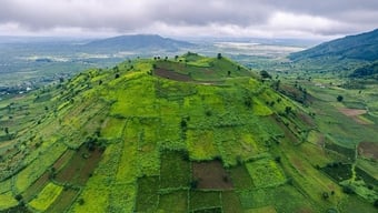
In 2012, a large Vietnamese flag was mounted on the roof of the conference hall of Truong Sa Lon Island, part of Truong Sa archipelago ( Khanh Hoa province). The ceramic flag measures 310 square meters (12.4m x 25m) and is made from 310,000 ceramic tiles measuring 3cm x 3cm.
This ceramic flag has been awarded a certificate by the Vietnam Record Organization as the largest ceramic national flag in Vietnam.

The image of the Vietnamese flag on Truong Sa Lon Island visible from satellite is the pride of the Vietnamese people (Screenshot).
The purpose of making this giant ceramic flag is so that people can clearly see the Vietnamese national flag on the Truong Sa archipelago when flying or viewing satellite images from Google Maps, Google Earth, etc.
This is a way to affirm Vietnam's sovereignty over the Truong Sa and Hoang Sa archipelagos.
Anyone who enters the coordinates 8⁰38'38.9"N 111⁰55'09.7"E into a search engine or on the Google Maps application, then switches to satellite view mode, can clearly see the image of the Vietnamese flag on Truong Sa Lon Island. Many people also nicknamed this coordinate "the coordinate of pride".
However, starting yesterday (July 10), many netizens in Vietnam when accessing the above coordinates through two Google map viewing applications, Maps and Earth, were surprised to realize that the Vietnamese flag on Truong Sa Lon Island had been blurred, replaced by just a blank space.
.")
However, this flag is now blurred on Google Maps, leaving only a white space (Screenshot).
Google's move has angered many Vietnamese netizens. Many social media users believe that Google intentionally blurred the Vietnamese flag to "appease" other countries that are disputing sovereignty over the archipelago, even though Vietnam is the only country that has legal sovereignty over the archipelago.
Many netizens in Vietnam have called for a "1-star" rating for Google Maps and Google Earth, as a way to protest Google's action of blurring the Vietnamese flag on Truong Sa Lon Island.
Google has not yet commented on the reason for blurring the Vietnamese flag on Truong Sa Lon Island.
Notably, this is not the first time Google has displayed incorrect information about sovereignty over the Hoang Sa and Truong Sa archipelagos.
In 2015, Google Maps displayed the name of Vietnam's Hoang Sa archipelago as Tam Sa, the name that the Beijing government gave to the Hoang Sa archipelago to illegally gain control.
Google Maps' move has angered the online community in Vietnam. In response to the wave of protests aimed at it, Google had to change the information on Google Maps, displaying the name of the Hoang Sa archipelago as the international name Paracel.
In 2020, Google Maps once again displayed serious incorrect information when it labeled Phu Lam beach in Tuy Hoa city ( Phu Yen ) as a beach belonging to China. Google then had to immediately correct this information after being reported and pressured by users in Vietnam.
dantri.com.vn


Comment (0)