On the afternoon of June 3rd, the Steering Committee for the implementation of land surveying, cadastral record keeping, and land database construction in Son La province (established according to Decision No. 982/QD-UBND dated April 21, 2026, of the Chairman of the People's Committee of Son La province) held a meeting to discuss the implementation of key tasks in the coming period.

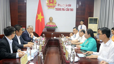
The Steering Committee for land surveying, cadastral record keeping, and land database construction in Son La province held a meeting to discuss future tasks. Photo: Nguyen Nga.
In implementing Directive No. 05/CT-TTg of the Prime Minister and Plan No. 2959/KH-BNNMT-BCA dated March 29, 2026, of the Ministry of Agriculture and Environment and the Ministry of Public Security on strengthening and promoting the work of surveying, mapping, and compiling cadastral records and completing the national land database, the People's Committee of Son La province has established a provincial-level Steering Committee, issued an implementation plan and numerous guiding documents. At the commune level, 65 out of 75 communes and wards have established Steering Committees.
The Department of Agriculture and Environment has issued a specific implementation plan, mobilizing 57 officials, civil servants, and employees from specialized departments, the Land Registration Office, and the forest protection force to participate in the working group to carry out the task.

Leaders of the Department of Agriculture and Environment report on the progress of task implementation. Photo: Nguyen Nga.
According to the report at the meeting, the province currently has over 2.6 million land parcels. As of June 1, 2026, 1,085,888 land parcels had data on the National Land Information System (VNLIS). Of these, 523,536 parcels met the criteria of "correct - complete - clean - viable," accounting for approximately 30%; 562,352 parcels had data but did not fully meet the criteria and are still being reviewed, supplemented, and standardized. The entire Son La province still has approximately 1.56 million land parcels without a database.
Regarding land surveying, the total natural area of the province is over 1.4 million hectares. To date, the area that has been officially surveyed, extracted for cadastral purposes, and surveyed for agricultural and forestry land has reached 269,405 hectares, equivalent to 19.1% of the natural area.
The construction of land databases has been implemented in 51 out of 75 communes and wards, reaching 68% of the commune-level administrative units. However, only 14 out of 51 communes have databases that are synchronized with land surveying and registration; 37 out of 51 communes have databases built from various previous sources, lacking consistency.
The biggest challenges facing Son La currently are the enormous volume of data that needs to be reviewed and standardized; many areas have not yet undergone formal cadastral surveying; there is a shortage of specialized land management personnel at the local level; and the need for funding to implement all tasks comprehensively remains high.

The meeting was connected online to communes and wards throughout the province. Photo: Nguyen Nga.
Concluding the meeting, Mr. Do Van Tru, Director of the Department of Agriculture and Environment and Deputy Head of the Standing Committee of the Steering Committee, requested that departments, agencies, and localities continue to focus on implementing tasks according to Plan No. 2959/KH-BNNMT-BCA of the Joint Ministry of Agriculture and Environment - Ministry of Public Security and Plan No. 114/KH-UBND of the Provincial People's Committee.
Priority should be given to completing the data enrichment and cleaning process for land parcels already in the database but not yet meeting the criteria of "accurate - complete - clean - viable," striving to complete it by June 2026. Local authorities should urgently establish commune-level Steering Committees and mobile support teams to go to each village, hamlet, and residential area to directly guide people in providing documents and records to support the land data standardization process.
For land parcels without existing databases, in areas where funding has been allocated, continue to develop tasks, approve plans and schedules for surveying, creating cadastral maps, and building databases. For communes with incomplete data, implement land parcel location plans linked to collecting records and documents from land users; simultaneously, closely coordinate with the police force in cross-checking, verifying, and synchronizing data with the national population database.
In 2026, Son La allocated 78.35 billion VND from land use revenue regulated for the local budget and 30 billion VND from the science, technology, innovation and digital transformation budget to serve the construction and completion of the land database.
Source: https://nongnghiepmoitruong.vn/hon-1-trieu-thua-dat-tai-son-la-da-cap-nhat-len-vnlis-d814752.html
![[Photo] First session of the 14th Congress of the Vietnam Trade Union](https://vphoto.vietnam.vn/thumb/1200x675/vietnam/resource/IMAGE/2026/06/03/1780465947883_ndo_br_img-3852-jpg.webp)
![[Photo] General Secretary and President To Lam presides over a meeting with the Central Organizing Committee.](https://vphoto.vietnam.vn/thumb/1200x675/vietnam/resource/IMAGE/2026/06/03/1780482764658_a1-bnd-4741-3342-jpg.webp)

![[Photo] Secretary of the National Assembly Party Committee, Chairman of the National Assembly presides over the meeting of the Standing Committee and Executive Committee of the National Assembly Party Committee.](https://vphoto.vietnam.vn/thumb/1200x675/vietnam/resource/IMAGE/2026/06/03/1780480353201_ndo_br_bnd-2585-jpg.webp)


![[Video] Sunset at Lap An Lagoon – Where the sun sets over the fishing nets](https://vphoto.vietnam.vn/thumb/1200x675/vietnam/resource/IMAGE/2026/05/31/1780192137701_beach-landscape-sea-water-nature-grass-745871-pxhere-com.jpeg)


Comment (0)