
Heavy rain in the dry season, Hanoi warns of flooding
As of yesterday, images of hail and thunderstorms in Hanoi continued to "go viral" on social media. For people in the southern provinces, the cooling rain that has been awaited for many months is still very far away. Therefore, "seeing" rain in the north but struggling under the southern sun is an image that many people compare.
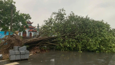
For Hanoi residents, the widespread thunderstorms, some places accompanied by strong winds and thunder 2 days ago, were still very surprising. In some areas such as Cau Giay, My Duc, Chuong My, Ung Hoa, hail even appeared. According to the Hanoi Green Parks Company, the above unusual weather phenomenon caused about 70 trees in the districts of Long Bien, Hoan Kiem, Gia Lam to fall and break. Among them, many large trees with diameters of 40 - 50 cm also fell, damaging many motorbikes and cars. This unusual heavy rain forced the National Center for Hydro-Meteorological Forecasting to issue a warning bulletin to Hanoi on April 20 about the risk of flooding for many inner-city streets with common flooding depths of 15 - 30 cm; some streets are likely to be flooded 30 - 40 cm deep.

A tree on Nha Chung Street (Hoan Kiem District, Hanoi) fell down, crushing many motorbikes on the sidewalk.
Hanoi Drainage Company said the average rainfall in the area was from 20 to 76 mm. The areas with the highest rainfall were Hoang Mai with 76.2 mm, Ha Dong with 55.8 mm, Hoan Kiem with 48 mm... Heavy rain caused localized flooding in many areas in Hanoi's inner city.
Not only Hanoi, heavy rain and extreme weather phenomena also occurred in many localities in the northern region. The National Center for Hydro-Meteorological Forecasting said that on the evening and night of April 20, in the North, there were showers and thunderstorms, with some heavy rain. The rainfall from 7:00 p.m. on April 20 to 7:00 a.m. on April 21 was over 50 mm (heavy rain) in some places such as: Cam Pha (Quang Ninh) up to 69.4 mm, Cau Giay (Hanoi) 63 mm, Minh Quang (Vinh Phuc) 54.9 mm, Phat Tich (Bac Ninh) 53.4 mm... Previously, heavy rain was also recorded in some places such as Huoi Leng (Dien Bien) 66 mm, Giap Dac ( Hoa Binh ) 41 mm. "Due to the low pressure trough with an axis of 24 - 26 degrees north latitude being compressed by the cool air mass from southern China flowing down, the northern part of our country has showers and thunderstorms," experts at the National Center for Hydro-Meteorological Forecasting explained the cause of heavy rain in the northern provinces.
According to the forecast, the North will still have scattered showers and thunderstorms in the evening, locally heavy rain with rainfall from 15 - 30 mm, some places over 50 mm. The Central and Central Highlands regions will also have localized showers and thunderstorms, with the possibility of tornadoes, lightning, hail and strong gusts of wind. Localized heavy rain is likely to cause flash floods on small rivers and streams, landslides on steep slopes and flooding in low-lying areas. The warning level of natural disaster risk due to tornadoes, lightning and hail is at level 1.

Ho Chi Minh City is experiencing prolonged intense heat, with temperatures often hovering around 40 degrees Celsius.
The South may experience unseasonal rain during the holidays.
While the northern provinces have had heavy rain, the common temperature in the southern provinces in recent days has remained between 35 - 37 degrees Celsius. Notably, due to the increasing humidity in the air, in the early morning and late afternoon, the sky has appeared many dark clouds, making many people hope for rain. However, the weather is "teasing", the more you hope, the more the rain "disappears", and the heat feels even more intense. In Ho Chi Minh City, although the meteorological temperature is only 34 - 35 degrees Celsius, the perceived temperature is always very high at 39 - 41 degrees Celsius. Currently, the Indo-Burma low pressure in the west is strong and encroaching on the east, directly affecting our country, causing severe heat in many regions.
According to the National Center for Hydro-Meteorological Forecasting, the heat wave in the Central Highlands and the South is likely to last until the first half of May. This year, the rainy season in the Central Highlands and the South appears later than the average of many years, from June the southwest monsoon tends to be stronger than average.
Responding to the possibility of unseasonal rain in Ho Chi Minh City as well as the southern provinces/cities, according to meteorological experts, currently the humidity in the air is still generally low, the amount of thunderstorms is still low, so the possibility of unseasonal rain is not high. If there are, they will only be small-scale thunderstorms and small amounts. In addition, due to the influence of the El Nino phenomenon, this year the heat is intense and the rainy season comes later than the average of many years. After the heat waves, by the end of April there may be some unseasonal rains. By the beginning of May, the southwest monsoon begins to appear, bringing rain and seasonal rains will begin to appear. This means that the upcoming April 30 - May 1 holiday in the South is likely to have seasonal rains in many places. Due to the prolonged heat, the transitional season will be accompanied by many extreme weather phenomena such as thunderstorms, tornadoes, lightning, hail, waterspouts, etc. "People need to pay special attention to avoid risks affecting their health and lives when having fun during the holidays celebrating National Reunification and International Labor Day," an expert warned.
Specifically, from around May 10 to 15, some localities will enter the rainy season, possibly starting from Phu Quoc and the Ca Mau peninsula. By the end of May, the entire Southern region will officially enter the rainy season. In the early stages of the season, the average rainfall is still generally lower than the average of many years. From July to August, the climate is likely to shift to La Nina status, with rainfall forecast to be more and higher than the average of many years.
In the immediate future, due to the influence of low pressure in the west, the heat will continue to last for many days to come. On April 22-23, the Central Highlands and the South will have heat, some places will have severe heat with the highest temperature commonly ranging from 36 - 37 degrees Celsius, some places will be over 38 degrees Celsius. Some areas will have particularly severe heat such as: the northwest of the North, the area from Thanh Hoa to Phu Yen, the area from Quang Binh to Quang Ngai with the highest temperature commonly ranging from 36 - 39 degrees Celsius, some places will be over 39 degrees Celsius. By May 25, the heat will continue to increase in intensity in many places in the South, the whole country will have severe heat.
Mekong Delta welcomes the last salinity wave of the season
This week, the South welcomes the full moon high tide of the third lunar month. The peak high tide may appear from April 24 to 26. On the Saigon River, the peak tide is approximately equal to or higher than alert level 2, the 4‰ salinity line penetrates 73 - 75 km deep. The risk level of natural disasters due to salinity intrusion is at the highest level, level 3.
In the western provinces, the National Center for Hydro-Meteorological Forecasting said: Water levels at stations on the Mekong mainstream are changing slowly with a downward trend and are 0.15 - 1.5 m lower than the average of many years. Saltwater intrusion is forecast to increase gradually from now until April 30 due to the influence of high tides. The 4‰ salinity boundary on the Dong and Tay Vam Co rivers can penetrate 90 - 120 km deep; Tien River mouth about 50 - 60 km, Hau River 40 - 50 km; Cai Lon River from 45 - 55 km.
After the high tide, saline intrusion in the Mekong Delta estuaries tended to decrease gradually, but remained at a high level; in particular, on the Vam Co, Cai Lon, and Cai Be rivers, saline intrusion increased until the first half of May, then gradually decreased from the second half of May. The level of natural disaster risk due to saline intrusion in the Mekong Delta is at level 2.
Source link


![[Photo] National Assembly Chairman Tran Thanh Man visits Vietnamese Heroic Mother Ta Thi Tran](https://vphoto.vietnam.vn/thumb/1200x675/vietnam/resource/IMAGE/2025/7/20/765c0bd057dd44ad83ab89fe0255b783)


Comment (0)