
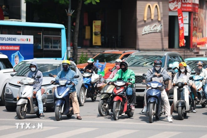
On July 18, the Northern region will have hot and extremely hot weather with the highest temperature commonly ranging from 35-38 degrees Celsius, some places above 38 degrees Celsius, hot weather lasting from 10am to 5pm.

According to the National Center for Hydro-Meteorological Forecasting, from July 18-19, many dangerous weather patterns will continue to occur on land and at sea.
The National Center for Hydro-Meteorological Forecasting said that on July 18-19, the area from Thanh Hoa to Da Nang , the eastern part of the provinces from Quang Ngai to Dak Lak and Khanh Hoa will have hot weather, some places will have severe heat with the highest temperature commonly ranging from 35-38 degrees Celsius, some places will have over 38 degrees Celsius; the lowest relative humidity is commonly from 50-55%, the hot weather will last from 10am to 5pm.
On July 18, the Northern region will have hot and extremely hot weather with the highest temperature commonly ranging from 35-38 degrees Celsius, some places above 38 degrees Celsius; the lowest relative humidity commonly ranges from 50-55%, the hot weather lasts from 10am to 5pm.
On July 19, the Northern Delta region will have hot weather with the highest temperature commonly ranging from 35-36 degrees Celsius, some places above 36 degrees Celsius; the lowest relative humidity commonly ranges from 60-65%, the hot weather will last from 12-16 hours.
"The forecast temperature in the heat bulletins and the actual temperature felt outdoors can differ by 2-4 degrees Celsius, or even higher depending on the conditions of the surface such as concrete and asphalt," noted Deputy Head of the Weather Forecast Department Nguyen Huu Thanh.
Warning, from July 20, the heat wave in the Northern Delta and Central regions will gradually decrease. The risk of natural disasters due to heat wave is level 1.
Due to the impact of hot weather, some places have severe heat combined with low humidity in the air and southwest wind causing the foehn effect, there is a risk of explosions and fires in residential areas due to increased demand for electricity and the risk of forest fires.
Heat can cause dehydration, exhaustion, and heat stroke in the human body when exposed to high temperatures for a long time. In addition, heat also directly affects production and people's lives.
To protect the health of yourself and your family during hot days, health experts recommend that people limit going out between 11am and 2pm every day.
If you have to go out, wear long-sleeved, long-legged clothing and a hat to cover your head and face to protect as much skin as possible.
People need to supplement enough and moderate water every day and every hour (it is best to choose types of water such as filtered water, fruit juice, pure green vegetable juice...) to prevent heat and compensate for lost water...
On July 17, the Northern region and the area from Thanh Hoa-Da Nang, the eastern part of the provinces from Quang Ngai-Dak Lak and Khanh Hoa will have hot weather with the highest temperature commonly ranging from 35-37 degrees Celsius, some places above 37 degrees Celsius such as Mai Chau station (Phu Tho) 37.2 degrees Celsius, Bac Quang station (Tuyen Quang) 37.5 degrees Celsius, Son Dong station (Bac Ninh) 38.2 degrees Celsius, Hoai Duc station ( Hanoi ) 37.7 degrees Celsius, Chi Linh station (Hai Phong) 37.5 degrees Celsius, Hoi Xuan station (Thanh Hoa) 37.2 degrees Celsius, Huong Khe station (Ha Tinh) 37.3 degrees Celsius... Relative humidity at the lowest level commonly ranges from 55-60%.
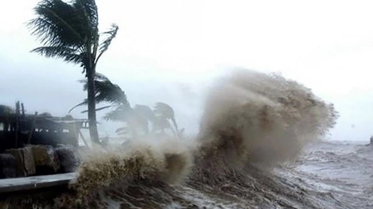
Strong winds and high waves in many coastal areas
The National Center for Hydro-Meteorological Forecasting informs that there are currently showers and thunderstorms in the eastern sea area of the North East Sea, the central and southern East Sea area (including Truong Sa special zone), the sea area from Ca Mau-An Giang and the Gulf of Thailand.
In Phu Quy special zone, there was strong southwest wind at level 5, sometimes level 6, gusting to level 7; at Huyen Tran station (South of East Sea), there was gusting to level 7.

Forecast for the day and night of July 18, the East of the North East Sea will have winds gradually increasing to level 6-7, the area near the storm's center will have strong winds of level 8-9, gusting to level 11, very rough seas, waves 3-5m high.
Sea area from Lam Dong to Ho Chi Minh City, central and southern East Sea (including Truong Sa special zone) wind level 6, gust level 7-8. Rough sea, waves 2-4m high.
In addition, on the day and night of July 18, the northern, central and southern East Sea (including the Hoang Sa and Truong Sa special zones), the sea area from Lam Dong to Ca Mau, from Ca Mau to An Giang and the Gulf of Thailand will have scattered showers and thunderstorms; especially the eastern sea area of the northern East Sea will have storms at night.
Warning, on the day and night of July 19, the North East Sea area will have strong winds of level 7-8, near the storm center, level 9-10, gusting to level 12; waves 4-6m high, very rough seas.
The sea area from Lam Dong to Ho Chi Minh City, the central and southern East Sea (including Truong Sa special zone) has strong southwest winds of level 6, sometimes level 7, gusting to level 8-9; waves 2-4m high, rough seas.
Level of disaster risk due to strong winds at sea: level 2, especially in the eastern sea area of the North East Sea level 3.
All vessels operating in the above areas are at high risk of being affected by cyclones, strong winds and large waves.
According to the guidance of the Ministry of Agriculture and Environment, affected coastal provinces and cities must closely monitor warning bulletins, forecasts and developments of strong winds at sea; notify captains and owners of vehicles and vessels operating at sea to proactively prevent and have appropriate production plans, ensuring safety of people and property; maintain communication to promptly handle possible bad situations./.
Source: https://baolangson.vn/nang-nong-gay-gat-tai-khu-vuc-bac-bo-co-noi-tren-38-do-c-5053556.html


![[Infographic] In 2025, 47 products will achieve national OCOP](https://vphoto.vietnam.vn/thumb/402x226/vietnam/resource/IMAGE/2025/7/16/5d672398b0744db3ab920e05db8e5b7d)


Comment (0)