
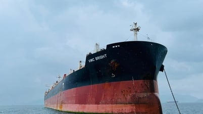
A Chinese scientist has used satellite remote sensing technology to accurately determine the source of the Congo River - the world's deepest river and the second longest in Africa, thereby redefining the actual length of the river to be 5,260km, much longer than previous estimates.
The Congo River is also known as the deepest river in the world , with a measured depth of more than 220m. In Africa, the Congo River is second only to the Nile in length and is famous for its abundant water resources.
Since the 19th century, many explorers and geographers have sought to approach and determine the source of this river.
However, the rugged terrain with many rapids, strong and complex currents, has made researching and accurately determining the origin of this river a great challenge for scientists.
Although the Chambeshi River in Zambia has long been considered the most upstream branch of the Congo River system, the exact location of its source remains controversial.
According to Mr. Liu Shaochuang, a researcher at the Institute of Space Information Research, Chinese Academy of Sciences, previous documents recorded the length of the Congo River ranging from 4,320-4,700km.
In the latest study to accurately determine the source and length of the river, Mr. Liu Shaochuang analyzed remote sensing images of the Congo River system and conducted two field surveys in the headwaters area.
The results showed that the starting point was located at coordinates 31.22 degrees East longitude and 9.19 degrees South latitude, at an altitude of 1,771m above sea level.
Based on this newly identified water source location, the Congo River is measured to be 5,260km long, significantly longer than previous estimates which ranged from 4,320 to 4,700km.
According to Mr. Liu Shaochuang, determining the length of a river depends largely on how the source is identified, the dataset used, and the measurement method.
Previously, documents often relied on outdated techniques or folklore, leading to inconsistencies in the data, the researcher said.
However, with today's modern technology, he believes that it is necessary to standardize criteria and update data, in which remote sensing technology is the most effective tool to determine river sources and measure length thanks to its ability to cover the entire basin.
According to international practice, the source of a river is defined as the most distant branch with year-round flow.
Based on this principle, Mr. Liu Shaochuang has applied a combination of satellite images and field surveys to re-establish the sources of more than 20 major rivers in the world, including the Yangtze River, the Yellow River, the Nile River and the Amazon River./.
Source: https://www.vietnamplus.vn/nha-khoa-hoc-do-lai-do-dai-cua-con-song-sau-nhat-the-gioi-post1039922.vnp


![[Maritime News] More than 80% of global container shipping capacity is in the hands of MSC and major shipping alliances](https://vphoto.vietnam.vn/thumb/402x226/vietnam/resource/IMAGE/2025/7/16/6b4d586c984b4cbf8c5680352b9eaeb0)


Comment (0)