
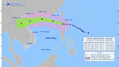
According to the forecast of the National Center for Hydrometeorology, at 1:00 p.m. on September 22, 2025: the center of super typhoon Ragasa was at about 19.4°N - 121.7°E, about 140km north of Luzon Island (Philippines). The strongest wind near the center of the super typhoon was level 17 (202-221 km/h), gusting above level 17. Moving in the West Northwest direction, speed about 20-25km/h. This is a very strong storm (currently reaching super typhoon level and will continue to maintain super typhoon level for the next 2 days when operating in the East Sea; wind strength is equivalent to and stronger than the maximum intensity of typhoon Yagi in 2024; the range of strong wind influence is very wide, from the 18th parallel northwards there are very strong winds; it is especially necessary to be on guard against thunderstorms before the storm directly affects even when the storm center is still about 300-400km away).
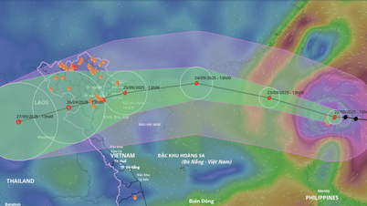
According to the forecast of the National Center for Hydro-Meteorological Forecasting, it is likely that storm Ragasa will directly affect the mainland of the Northern and North Central provinces, including Quang Ninh . To proactively prevent, combat and respond to storm Ragasa early and from afar; at the same time, strictly implement the direction of the Prime Minister in Official Dispatch No. 170/CD-TTg dated September 22, 2025 on proactively responding to super storm Ragasa, the Standing Committee of the Provincial Party Committee requests:
Party committees, authorities, the Fatherland Front and socio- political organizations, departments, branches, localities, the coal industry, relevant agencies and units proactively coordinate with the Provincial Civil Defense Command to focus on leading, directing, and organizing the serious and full implementation of the instructions in the Prime Minister's Official Dispatch, noting:
(1) Do not be negligent or subjective; organize regular and continuous monitoring and updating of information on the storm's developments to proactively direct and deploy response work appropriate to specific developments at agencies, units, and localities.
(2) Deploy as soon as possible measures to prevent and combat storms at sea, on islands, in coastal areas and on land, first of all, to review and count all local vessels and vehicles operating at sea and coastal areas; by all means inform ship owners and captains of vessels and vehicles still operating at sea about the developments and forecast of the storm's movement; call and guide vessels and vehicles to safe shelters; at the same time, based on the specific situation of risks and the level of impact of the storm on the locality, proactively decide to restrict vessels and vehicles from going to sea, operating at sea or prohibit the sea when necessary (pay attention to prevent storms and lightning before the storm directly affects).
(3) Arrange forces, materials, and means in unsafe areas before the storm directly affects them (construction works, projects in progress, camps, temporary houses, coal mining sites, mine waste dumps, underground spillways, along rivers and streams, etc.). Proactively evacuate people and carry out response, rescue, and relief work when bad situations occur to ensure the safety of people's lives, limit damage to people's and State's property, and avoid being passive or surprised in any situation.
Source: https://baoquangninh.vn/quang-ninh-chu-dong-phong-chong-ung-pho-voi-sieu-bao-ragasa-3377008.html

![[Photo] Prime Minister Pham Minh Chinh chairs the first meeting of the Central Steering Committee on housing policy and real estate market](https://vphoto.vietnam.vn/thumb/1200x675/vietnam/resource/IMAGE/2025/9/22/c0f42b88c6284975b4bcfcf5b17656e7)


![[Photo] General Secretary To Lam presents the First Class Labor Medal to the Vietnam National Energy and Industry Group](https://vphoto.vietnam.vn/thumb/1200x675/vietnam/resource/IMAGE/2025/9/21/0ad2d50e1c274a55a3736500c5f262e5)


Comment (0)