
In the process of learning social sciences , especially History and Geography, observing maps helps students visualize events and phenomena more clearly. From an abstract concept in textbooks, knowledge becomes concrete, with illustrations. Therefore, maps and atlases have long been considered indispensable learning materials in teaching and learning.
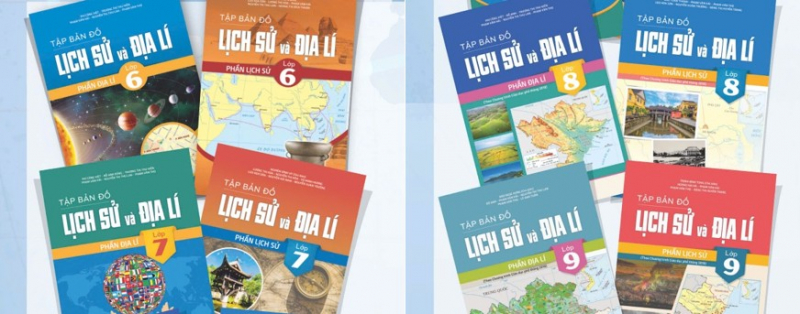
With the new requirements of the education program, the History and Geography Atlas for Secondary Schools was compiled by the Northern Educational Equipment and Books Joint Stock Company (Vietnam Education Publishing House) to accompany teachers and students in many different stages: teaching new knowledge, reviewing, testing and evaluating regularly and periodically. Thanks to that, this set of documents not only serves teaching in class but also supports students in self-study and self-consolidation of knowledge.
The highlight of the atlas is its compatibility with the 2018 General Education Program. The content is built on the requirements to be achieved, suitable for each grade from 6 to 9. Thanks to that, students can use the atlas as a companion document throughout the four years of secondary school.
In the History section, the map shows the stages of national development, changes in boundaries or the development of some important events. In the Geography section, the map provides information about natural features, population distribution, and economic activities. These images help students form visual symbols, making it easy to remember knowledge.
Not only is the atlas an illustration, it is also designed to be used in many different ways. Teachers can use the atlas to ask questions, open discussions, ask students to comment, compare, and analyze. Students can use it to review what they have learned, practice reading and analyzing maps, or use it as a supporting document during their review before an exam.
Using maps like this makes the learning process more active. Instead of just listening to lectures and taking notes, students are directly involved in searching and processing information. Through this, they develop the skills of observation, analysis and generalization - skills necessary for learning History and Geography.
The atlas was compiled with the participation of many experts, lecturers, and teachers with experience in both fields. In the History section, there are authors such as Dinh Ngoc Bao, Nghiem Dinh Vy, Trinh Dinh Tung, and Pham Van Hai. In the Geography section, there are Dao Ngoc Hung, Do Anh, and Pham Van Hai.

One of the values of atlases is their ability to help students practice analytical and synthetic thinking. By observing different maps, students can see changes in territory, changes in population distribution, or the relationship between natural conditions and economic and social life. From there, they learn to see things in dynamic relationships, instead of just absorbing knowledge in one direction.
In addition, frequent use of maps also trains students in reading data, processing visual information and expressing comments. These are useful skills not only in learning History and Geography but also in many other subjects. In the context of education shifting from content approach to capacity development, visual learning materials such as atlases play an important role. Students' self-exploitation of information from maps helps them to be more proactive, more creative and have the opportunity to practice problem-solving skills. At the same time, teachers also have more means to innovate teaching methods.
Source: https://cand.com.vn/giao-duc/tap-ban-do-lich-su-va-dia-li-thcs-nguon-hoc-lieu-truc-quan-gop-phan-doi-moi-day-va-hoc-i782182/


![[Photo] General Secretary To Lam attends the 1st Congress of the Central Party Committee of the Fatherland Front and Central Mass Organizations](https://vphoto.vietnam.vn/thumb/1200x675/vietnam/resource/IMAGE/2025/9/23/2aa63d072cab4105a113d4fc0c68a839)


![[Photo] Prime Minister Pham Minh Chinh chairs the first meeting of the Central Steering Committee on housing policy and real estate market](https://vphoto.vietnam.vn/thumb/1200x675/vietnam/resource/IMAGE/2025/9/22/c0f42b88c6284975b4bcfcf5b17656e7)


Comment (0)