
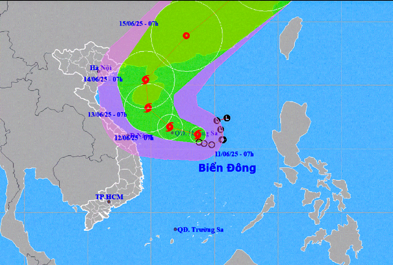
At 7:00 a.m. on June 11, the eye of the storm was located in the sea east of the Hoang Sa archipelago. The strongest wind near the eye of the storm was level 8 (62-74 km/h), gusting to level 10; moving slowly in a west-northwest direction at a speed of about 5-10 km/h.
 |
| Location and forecast direction of storm number 1. |
Storm No. 1 is forecast to continue moving west-northwest and is likely to strengthen. At 7:00 a.m. on June 12, Storm No. 1 was located in the Hoang Sa archipelago with winds of level 9, gusting to level 11. The storm then changed direction, likely moving towards China's Hainan Island.
Forecast of storm impact, the northern East Sea (including Hoang Sa archipelago) and the northern central East Sea area will have thunderstorms, strong winds of level 6-7, later increasing to level 8, gusting to level 11; rough seas, waves 2.5-4.5m high. The southern sea area of the central East Sea area will have strong southwest winds of level 6, sometimes level 7, gusting to level 8-9, waves 2-4m high, rough seas.
Khanh Hoa sea area has showers and strong thunderstorms, strong southwest winds of level 5, level 6, gusts of level 7-8, waves 2-3m high, rough seas. The sea area south of the East Sea including Truong Sa archipelago has strong southwest winds of level 6, sometimes level 7, gusts of level 8-9, waves 2-4m high, rough seas. Ships in the danger zone should be aware of the high risk of thunderstorms, tornadoes, strong winds and big waves.
According to a quick report on the morning of June 11 from the Provincial Border Guard Command, to proactively respond to storm No. 1, the authorities are maintaining permanent forces and means, proactively ready to respond to the storm; directing units to count and count the number of people and fishing boats fishing in the sea areas, especially dangerous areas; watchtowers are on duty 24/24 hours, informing about the developments of natural disasters so that fishing boat owners know and proactively take shelter safely.
According to statistics, Khanh Hoa has 481 vessels, with 2,637 fishermen operating at sea. Of these, no vessels are in dangerous areas. Currently, vessels operating at sea and aquaculture households have grasped information about the storm and have proactive plans to avoid it.
According to the news of the professional agency, in the afternoon and night of June 11, the South Central region is forecast to have moderate rain, heavy rain and thunderstorms, locally very heavy rain with common rainfall of 30-70mm, some places over 150mm. During thunderstorms, there is a possibility of tornadoes, lightning, hail and strong gusts of wind. Heavy rain is likely to cause flooding in low-lying areas, urban areas, industrial zones; flash floods on small rivers and streams, landslides on steep slopes. From June 14, the rain will decrease.
H.D
Source: https://baokhanhhoa.vn/xa-hoi/202506/tau-thuyen-cua-khanh-hoa-da-nam-thong-tin-ve-con-bao-so-1-9d513d4/


Comment (0)