
The Saigon River and the areas along its banks are identified as the "frontage" for developing a modern urban strip in the revised Ho Chi Minh City planning until 2040. To achieve this, a riverside road is needed to develop commerce and services, create scenic highlights, promote green economic development, boost tourism, and establish residential clusters interspersed with green spaces.
1.
Can Le Stream in Binh Phuoc province is the source of the 256km-long Saigon River, which merges with the Dong Nai River at Nha Be before splitting into two: the Long Tau River and the Soai Rap River. Hence the folk song, "Nha Be's river flows and divides in two / Whoever goes to Gia Dinh or Dong Nai, let them go," from the time of the Nguyen lords' migration and expansion of the South. The Soai Rap River is also the Saigon River – the lifeblood of the 40,000-hectare Can Gio mangrove forest before flowing into the sea. The entire 80km stretch flows through Ho Chi Minh City.
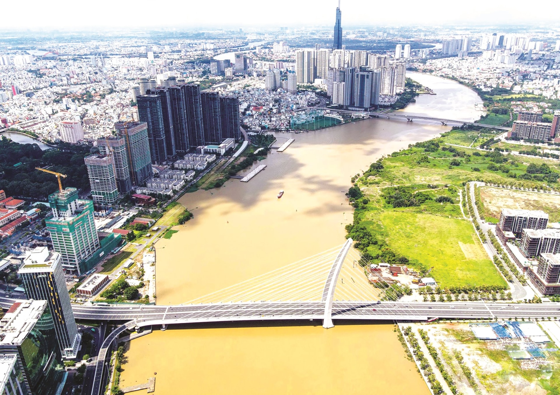
Flowing through the heart of Ho Chi Minh City, with a water surface width of 225-370m and a depth of around 20m, the Saigon River meanders gently, carrying alluvial deposits that created the Thanh Da Peninsula (6.35km²) and the Thu Thiem Peninsula (7.31km²). More than half of the Thanh Da Peninsula has long been urbanized, while the rest is neither fully urban nor fully rural. The Thu Thiem Peninsula is gradually becoming the most modern urban area in the country, yet it still retains most of its canals and waterways, teeming with hundreds of types of wild plants and the sounds of bitterns calling twice a day during high and low tides. This is a rare and unique gift that the Saigon River has bestowed upon humanity.
For over 300 years, Saigon has not been a city "by the river," but rather an urban center situated amidst waterways with a complex network of canals and waterways. Continuously from the 17th to the 20th centuries, Saigon transformed from an unknown place into a port city, a major waterway hub connecting the Mekong Delta and the Eastern region, leading the country in trade.
Saigon "grew up" with its unique riverine identity, which is the cultural root of Ho Chi Minh City today. Among these canals, besides the Saigon River, are the Ben Nghe - Tau Hu canal (approximately 22km), the Nhieu Loc - Thi Nghe canal (nearly 8km), the Tham Luong - Ben Cat - Nuoc Len canal (31km), the Xuyen Tam canal (6.2km), and the Tan Hoa - Lo Gom canal (7.24km). Thankfully, these canals have not been filled in and are being renovated and restored to their original state, with gradually reduced pollution and the return of historical landscapes to a city increasingly covered in concrete.
However, to date, the potential of this river and canal ecosystem has not been fully exploited, mainly for waterway transport, while other significant benefits remain potential, or rather, the advantages of this river have not yet been fully utilized.
Rivers and canals are formed naturally, while cities with complex infrastructure are man-made. Rivers and canals, or more broadly, the riverine landscape in Ho Chi Minh City, are symbolic representations of the city's face, serving as vast public spaces closely linked to sustainable development. Therefore, they require careful planning to ensure diverse functions and protect the natural ecosystem.
2.
According to the revised urban planning project for 2040, with a vision to 2060, Ho Chi Minh City will have approximately 17.4 million people by 2040, increasing to 20 million by 2060. The goal is to become the economic, financial, and service center of Asia. Therefore, it will develop according to a multi-center urban model, using the Saigon River corridor as the "front" for urban development along both sides of the river, essentially "shifting" towards the Saigon River to exploit its advantages.
Therefore, the Vietnam Association of Scientific and Expert Consultants Global (AVSE Global) and the Institute for Regional Planning of Paris, France (IPR) proposed dividing the Saigon River corridor into four sub-zones along the river's length to develop the spatial advantages of the riverside corridor while preserving historical and cultural values. Specifically, they proposed building 17 riverside parks – also serving as waterfront spaces – to concentrate cultural, artistic, and festival activities, as well as promoting trade, tourism, and services closely linked to the riverside life of Ho Chi Minh City and the Mekong Delta.
The first zone is the section of the Saigon River passing through Cu Chi District, where both banks are still relatively unspoiled, so it is dedicated to developing a nature park to preserve the landscape and combine it with the development of high-tech agriculture.
The second zone, largely situated on the border between Ho Chi Minh City and Binh Duong province, is a suburban area that will develop into an agricultural eco-park to promote tourism.
The third zone focuses on the Thanh Da peninsula (Binh Thanh district) and its surrounding areas, developing into a high-density mixed-use urban area with parks, green spaces, and wetland recreational areas.
Finally, the section through the city center, from the confluence of the Dong Nai River to the Saigon Bridge, is the entrance to the urban core; therefore, the Saigon River corridor is envisioned as a multi-functional complex with modern buildings.
The consulting firm also proposed the construction of a large-scale, internationally-standard cultural, commercial, and service area in Tan Thuan (District 7), and the planning of a Saigon River corridor connecting to the Soai Rap River in Can Gio to develop the marine economy.
The development orientation of the river corridor will be based on the principle of preserving natural, cultural, and historical values while ensuring rational exploitation during the development process.
To achieve this, in the coming years, while the road on the left bank is not yet completed, a 63km, 4-lane road must be built on the right bank of the Saigon River. Six or eight lanes would be "too wide" and unsuitable for the waterway's surface area. This road would connect Mui Den Do at the Nha Be intersection where the water divides (District 7) to Ben Suc Bridge (Cu Chi District). This route would connect Cu Chi District - Hoc Mon District - District 12 - Binh Thanh District - District 1 - District 2 - District 4 - District 7, reducing travel time from northern Cu Chi to the city center to approximately 30 minutes, instead of over two hours. This route would also connect to Ring Roads 2, 3, and 4 and various expressways.
The Saigon riverside road project is among the key projects prioritized for investment and construction by Ho Chi Minh City leaders from 2024 to 2030.
Initially, the project involves constructing a 31-35m wide section of road from Ba Son Bridge to Tan Cang, and a 20-50m wide section from Saigon Bridge to Thanh Da, connecting Ton Duc Thang Street in District 1 to the Tan Cang and Thanh Da areas in Binh Thanh District (passing through two residential areas: Saigon Pearl and Vinhomes). Upon completion, the road will open a new route from Thanh Da to the city center, providing residents with more access to the river and access to some of the most valuable street frontages in Ho Chi Minh City.
The National Assembly has passed Resolution 98 on piloting a number of specific mechanisms and policies for the development of Ho Chi Minh City, creating conditions for Ho Chi Minh City to unlock resources, create momentum for development, and maximize its potential and strengths, especially the road and river routes along and on the Saigon River.
3.
Rivers are a crucial component of urban areas, so in master planning, they must be preserved, developed, and renovated to maximize their advantages. The Saigon River is a gift from nature; if properly planned and renovated, in 10-15 years it will become a stunning landscape of Ho Chi Minh City, an indispensable destination for residents and tourists – a unique destination connected to the scenery and the history of Saigon - Ho Chi Minh City's formation and development.
Source: https://daidoanket.vn/the-vuong-song-sai-gon-10298929.html


Comment (0)