
Latest storm news: This afternoon (December 23), the tropical depression in the sea northwest of Truong Sa archipelago has strengthened into a storm, storm number 10 of 2024, internationally named PABUK.
1. Update the latest news on storm number 10
Storm status: This afternoon (December 23), the tropical depression in the sea northwest of Truong Sa archipelago has strengthened into a storm, storm number 10 of 2024, internationally named PABUK.
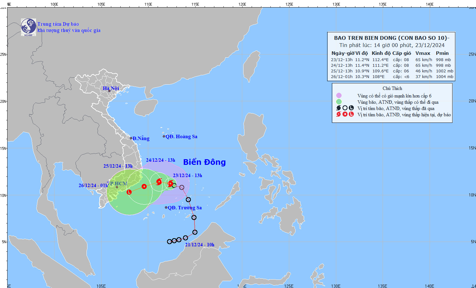
The movement of storm No. 10. Photo: nchmf
At 1 p.m., the center of storm No. 10 was at about 11.2 degrees North latitude; 112.4 degrees East longitude, in the northwest area of Truong Sa archipelago. The strongest wind near the center of the storm was level 8 (62-74 km/h), gusting to level 10 ; moving in the West Northwest direction, speed about 10 km/h.
Forecast of storm No. 10 in the next 24 to 60 hours
| Forecast time | Direction, speed | Location | Intensity | Danger zone | Disaster Risk Level (Affected Area) |
| 13:00/24/12 | West Northwest, 5-10km/h | 11.4 N-111.2E; on the southwestern sea area of the Central East Sea | Level 8, level 10 | 9.5N-13.5N; 110.0E-114.5E | Level 3: North of the South China Sea area (including the area north of the Spratly Islands), the sea area southwest of the Central China Sea area |
| 13:00/25/12 | West Southwest, about 5-10 km/h and gradually weaken into a tropical depression | 10.9N-109.6E; on the sea from Phu Yen to Ba Ria-Vung Tau | Level 6, level 8 jerk | 9.0N-12.5N; 109.0E-112.5E | Level 3: sea area from Phu Yen to Ba Ria-Vung Tau; sea area southwest of the central East Sea area, sea area northwest of the southern East Sea area (including the area northwest of Truong Sa archipelago) |
| 01h/26/12 | West Southwest, 10-15 km/h and gradually weakening into a low pressure area | 10.3N-108.0E; on the sea from Binh Thuan to Tra Vinh |
Forecast of the impact of storm No. 10
At sea: The sea area north of the South China Sea (including the area north of Truong Sa archipelago) and the sea area southwest of the Central China Sea have strong winds of level 6-7, the area near the storm's center has strong winds of level 8, gusts of level 10, waves 4.0-6.0m high; rough seas.
Vessels operating in the above mentioned dangerous areas are susceptible to the impact of storms, whirlwinds, strong winds and large waves.
Source: https://danviet.vn/chinh-thuc-tin-bao-moi-nhat-ap-thap-nhiet-doi-da-manh-len-thanh-con-bao-so-10-nam-2024-20241223145214124.htm
![[Photo] Standing member of the Secretariat Tran Cam Tu works with the Standing Committee of the Party Committee of the Ministry of Health](https://vphoto.vietnam.vn/thumb/1200x675/vietnam/resource/IMAGE/2025/10/10/1760079818773_image-4-6972-jpg.webp)


![[Photo] "Exposing letters" in the flood center of Lang Son](https://vphoto.vietnam.vn/thumb/1200x675/vietnam/resource/IMAGE/2025/10/10/1760080117518_ndo_br_z7101324112737-07cd4d1c01801a8ccf4ae0cbaf31c4a3-507-jpg.webp)
![[Photo] Unique Phu Gia horse hat weaving craft](https://vphoto.vietnam.vn/thumb/1200x675/vietnam/resource/IMAGE/2025/10/10/1760084018320_ndo_br_01-jpg.webp)


Comment (0)