
 |
| Photo: Hong Giang/VNA |
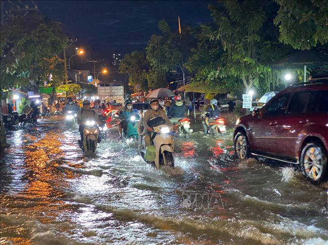
High tides cause flooding in low-lying areas
On the afternoon of May 27, commenting on the tide situation along the Southeast coast, Head of the Oceanographic Forecast Department, National Center for Hydro-Meteorological Forecasting Bui Manh Ha said that the tide level on the eastern coast of the South is currently at a high level. The highest water level observed at Vung Tau station was 3.88 m at 2:00 a.m. on May 27.
It is forecasted that from the evening of May 27 to May 28, the coastal areas of provinces and cities from Vung Tau to Ca Mau will have the highest water level of about 3.9 - 4.1 m, the time of high water is about 2 - 6 am and 10 - 12 pm every day, the areas at risk of flooding due to high tides are low-lying areas and areas outside the dike.
Warning in the next 24 - 48 hours, water levels in the Southeast coast will continue to be high. The highest water level at Vung Tau station is forecasted to be around 4 - 4.05 m.
Hydrological experts note that high tides will slow down the flood drainage process on rivers in the Southeast. Low-lying coastal areas, riverbanks, and areas outside the dykes in the Southeast are likely to be flooded in the early morning and early afternoon. In addition, high tides during this period also increase saltwater intrusion in the fields.
To proactively respond and minimize damage caused by high tides causing flooding in the coming time, the Department of Dyke Management and Natural Disaster Prevention and Control under the Ministry of Agriculture and Environment recommends that affected provinces and cities closely monitor forecasts and warnings, and promptly provide information to authorities and people at all levels for proactive prevention.
Authorities inspect and review coastal residential areas, dykes, dams, low-lying areas, and areas at high risk of flooding to proactively organize the relocation and evacuation of people when situations arise; clear the flow, and promptly handle construction incidents from the first hour.
Provinces and cities are ready to deploy measures to drain water and protect production; reinforce and protect aquaculture ponds; harvest crops and upland plants that are ready for harvest; prevent and combat flooding in urban areas and low-lying areas, ensuring minimal damage; notify owners of water transport vehicles about flooding to proactively take measures to ensure safety for people, vehicles, equipment and works.
Thunderstorms over many coastal areas
Regarding the sea weather, Deputy Head of Weather Forecast Department, National Center for Hydro-Meteorological Forecasting Le Thi Loan said that currently in the southern area of the Gulf of Tonkin, the sea area from Quang Tri to Binh Dinh, the northern East Sea area (including the sea area of Hoang Sa), the central and southern East Sea area (including the sea area of Truong Sa) there are scattered showers and thunderstorms.
It is forecasted that on the night of May 27 and May 28, the southern Gulf of Tonkin, the sea area from Quang Tri to Ca Mau, Ca Mau to Kien Giang and the Gulf of Thailand, the northern East Sea area (including Hoang Sa area), the central and southern East Sea area (including Truong Sa area) will have scattered showers and thunderstorms, with the possibility of tornadoes, strong gusts of wind level 6-7, and waves over 2 meters high.
All vessels operating in the above areas are at risk of being affected by tornadoes and strong gusts of wind.
According to the guidance of the Ministry of Agriculture and Environment, affected coastal provinces and cities must closely monitor warning bulletins, forecasts and developments of strong winds at sea; notify captains and owners of vehicles and vessels operating at sea to proactively prevent and have appropriate production plans, ensuring safety of people and property; maintain communication to promptly handle possible bad situations.
Many areas of heavy rain
Regarding the rain situation, Deputy Head of Weather Forecasting Department Le Thi Loan said that from the evening of May 28 to May 29, the Northern region will have moderate rain, heavy rain, thunderstorms, and some places will have very heavy rain with common rainfall from 30 - 90 mm, locally over 180 mm.
From early morning and on May 29, the North Central region will have moderate rain, heavy rain and thunderstorms, some places will have very heavy rain with common rainfall of 30 - 50 mm, locally over 100 mm.
From the afternoon of May 28 to May 29, in the Central Highlands and the South, there will be moderate rain, heavy rain and thunderstorms, some places will have very heavy rain with common rainfall of 30 - 60mm, locally over 100mm.
Warning of risk of localized heavy rain over 100 mm in 3 hours, thunderstorms with possibility of tornadoes, lightning, hail and strong gusts of wind.
On the night of May 29, the Northwest region of the North and the Northern Delta will have moderate rain, heavy rain and thunderstorms, locally very heavy rain with rainfall ranging from 15 - 30 mm, in some places over 60 mm. In other places in the North, Central Highlands and the South from the night of May 29, heavy rain will tend to decrease.
On the night of May 29 and early morning of May 30, the North Central region will have moderate rain, heavy rain, thunderstorms, and locally very heavy rain with rainfall ranging from 20 - 40 mm, with some places over 70 mm. From May 30, heavy rain will tend to decrease, with the possibility of tornadoes, lightning, hail, and strong gusts of wind in thunderstorms. Warning level 1 for natural disaster risks due to heavy rain.
Heavy rains are likely to cause flooding in low-lying areas, urban and industrial areas; flash floods on small rivers and streams, landslides on steep slopes (real-time warning information on areas at risk of flash floods and landslides is provided online on the website of the Department of Hydrometeorology at: https://luquetsatlo.nchmf.gov.vn and in separate bulletins warning of flash floods and landslides).
To prevent flash floods and landslides, disaster prevention experts say that provinces and cities need to use structural and non-structural solutions.
Regarding engineering measures, provinces and cities need to plant and protect upstream protective forests, especially in areas that often cause flash floods, to protect the ecological environment, protect the vegetation cover, increase the water retention capacity of the basin, limit the ability to concentrate flood flows, and at the same time build flood-regulating reservoirs in areas where flash floods often occur, clear flood drainage routes, build dikes, flash flood walls, divide flood flows, build additional spillways in reservoirs, etc.
For non-structural measures, localities need to create flash flood risk zoning maps (high risk; medium risk and areas with low risk of flash floods). This map is one of the important bases for localities to propose measures to prevent flash floods; land use planning to limit development in areas with high risk of flash floods. For residential areas that have developed without planning in the past, localities need to re-plan and resettle, moving people out of areas with high risk of flash floods, landslides, etc.
According to VNA
Source: https://baoapbac.vn/xa-hoi/202505/trieu-cuong-o-muc-cao-mua-lon-gio-manh-va-song-cao-tren-dat-lien-va-tren-bien-1043736/


![[Maritime News] More than 80% of global container shipping capacity is in the hands of MSC and major shipping alliances](https://vphoto.vietnam.vn/thumb/402x226/vietnam/resource/IMAGE/2025/7/16/6b4d586c984b4cbf8c5680352b9eaeb0)


Comment (0)