Record snowfall in recent years is not enough to offset prolonged drought and increased groundwater demand in the United States, according to an analysis of NASA satellite data.
The drop in water levels in the Great Salt Lake and Lake Mead is evidence of a drought that has been raging since 2000. But surface water makes up only a small portion of the Great Basin. Much of the water that supplies California, Utah and Oregon is underground. That makes it difficult to track the impact of drought on the Great Basin’s overall water supply.
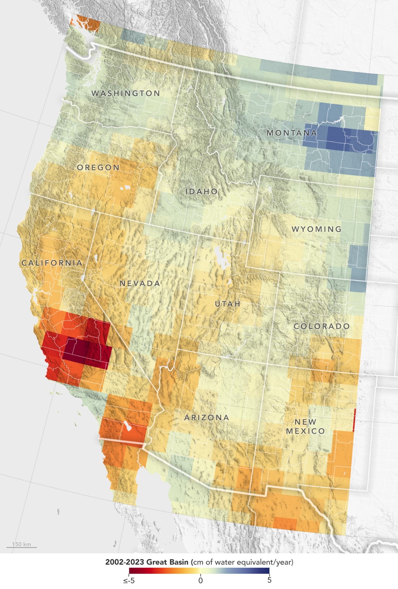
A new look at 20 years of data from the Gravity Recovery and Climate Experiment (GRACE) satellite series shows that groundwater depletion in the Great Basin far exceeds surface water losses.
Over the past two decades, groundwater supplies in the basin have declined by 68.7 cubic kilometers. That’s about two-thirds of the water used by the entire state of California in a year and about six times the total amount of water remaining in Lake Mead, the largest reservoir in the United States.
Although satellites show increased water levels in the spring due to snowmelt from higher elevations, University of Maryland earth scientist Dorothy Hall said this is unlikely to prevent a sharp drop in water levels in the American Southwest.

Satellites show red areas recording severe water loss.
“In years like the winter of 2022-2023, I expect record snowfall to actually help replenish groundwater supplies,” Hall said. “But overall, the decline continues.” The study was published in March 2024 in the journal Geophysical Research Letters.
“A major reason for this decline is upstream diversions for agricultural and residential use,” Hall said. According to the U.S. Census Bureau, the population of states that rely on the Great Basin for water has increased from 6% to 18% since 2010. As populations grow, so does water demand.
Increased evaporation and the demands of the region's plants are exacerbating the problem. "With the constant threat of drought, farmers downstream often don't have enough water," Hall said.
While groundwater level gauges in the Great Basin show declining groundwater, satellite data provide a more complete picture of the total amount of water lost in the region.
The GRACE satellites flew from March 2002 to October 2017. The GRACE–Follow On (GRACE–FO) satellites launched in May 2018 continue to monitor changes in Earth's gravity due to changes in water mass.
The GRACE-based water level map has improved as the team has learned to parse more detail from the data. The improved resolution also allows for about 10 times better location discrimination than previous analyses.
Reduced water supplies can affect both humans and animals. In addition to affecting drinking water and irrigation, shallow water exposes pollutants to the lakebed, causing air pollution. Shrinking lakes put pressure on bird populations that rely on lakes as stopovers during migration.
“The ultimate solution will have to involve more intelligent water management,” says researcher Hall.
According to NASA
Migration
Source: https://giadinh.suckhoedoisong.vn/ve-tinh-my-phat-hien-tinh-trang-khong-mong-muon-dien-ra-mot-cach-dang-bao-dong-chuyen-gia-lac-dau-khong-bu-dap-noi-17224121107123732.htm


![[Infographic] In 2025, 47 products will achieve national OCOP](https://vphoto.vietnam.vn/thumb/402x226/vietnam/resource/IMAGE/2025/7/16/5d672398b0744db3ab920e05db8e5b7d)


Comment (0)