
QNgTV- According to the National Center for Hydro-Meteorological Forecasting, a tropical depression is active in the eastern central region of the Philippines and is likely to strengthen into a storm in the next 24-48 hours.
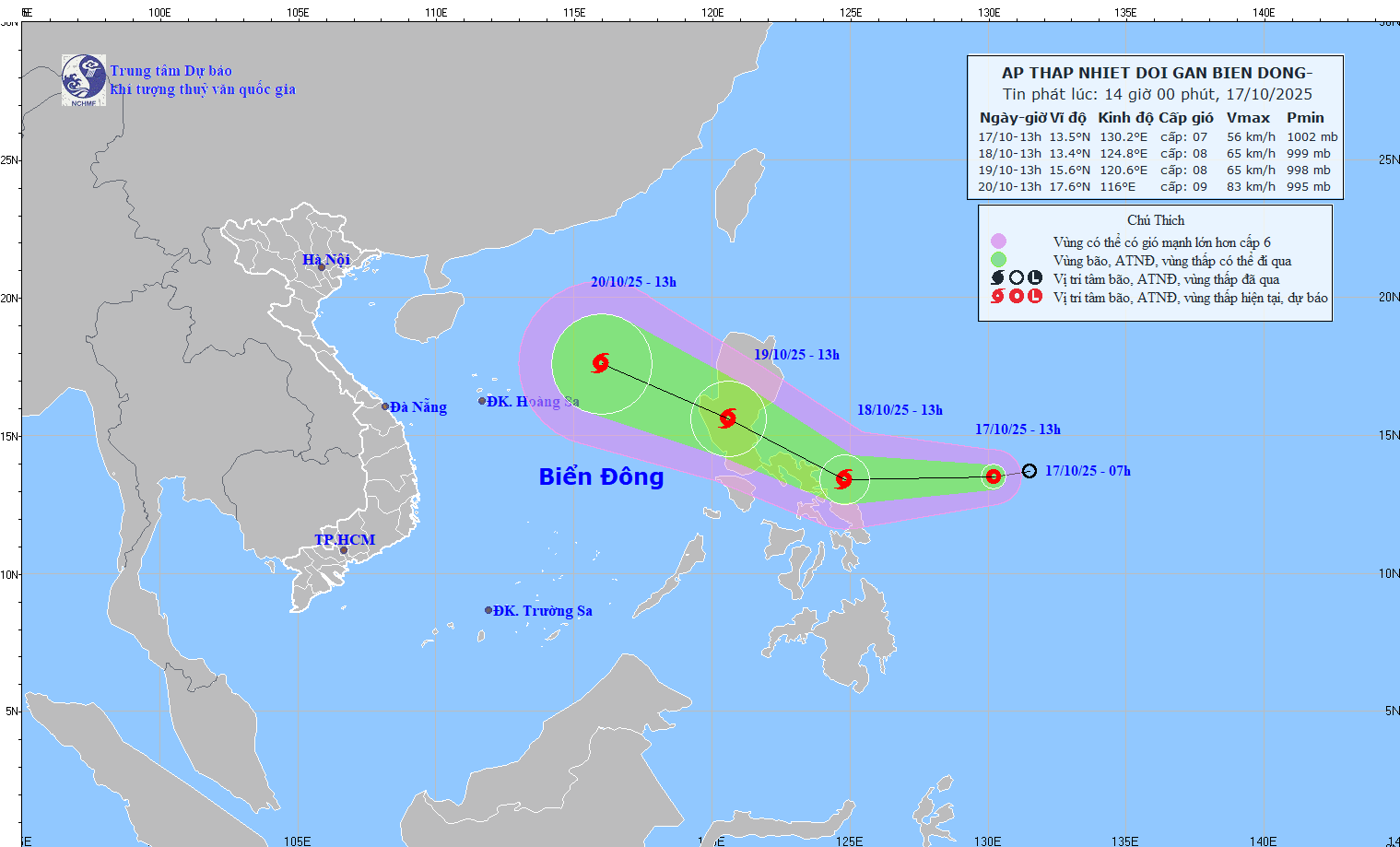
On October 17, the center of the tropical depression was located at about 12.6 degrees North latitude - 127.2 degrees East longitude, about 400km east of the central Philippines. The strongest wind near the center of the tropical depression was level 6 (from 39-49 km/h), gusting to level 8.
In the next 24 to 48 hours, this low pressure area will continue to move mainly in the West direction, at a speed of about 20-25 km/hour.
It is expected that by 1:00 p.m. on October 18, the center of the low pressure area will be at about 13.4 degrees North latitude - 124.8 degrees East longitude, east of the central Philippines, and is likely to strengthen into a storm, with strong winds of level 8, gusts of level 10.
By 1 p.m. on October 19, the storm is forecast to move west-northwest, maintaining a speed of about 20-25 km/h, and will pass Luzon Island (Philippines). In this area, the storm maintains a level 8 intensity, gusting to level 10.
The area between 14.5 and 18.5 degrees North latitude, east of 118.5 degrees East longitude, that is, the sea area northeast of the East Sea, will be in the strong wind and danger zone, with a level 3 natural disaster risk level.
On land, due to the influence of the circulation far from the tropical low pressure area, in the coming days, the Central and Southern regions may experience localized showers and thunderstorms, with some places experiencing moderate to heavy rain; winds will gradually increase in the eastern and northern seas of the East Sea. Authorities recommend that vessels operating in the East Sea area should regularly update information and proactively move away from dangerous areas to ensure the safety of people and vehicles.
Source: https://quangngaitv.vn/ap-thap-nhiet-doi-gan-bien-dong-co-kha-nang-manh-len-thanh-bao-6508794.html
![[Photo] Closing ceremony of the 18th Congress of Hanoi Party Committee](https://vphoto.vietnam.vn/thumb/1200x675/vietnam/resource/IMAGE/2025/10/17/1760704850107_ndo_br_1-jpg.webp)


![[Photo] Nhan Dan Newspaper launches “Fatherland in the Heart: The Concert Film”](https://vphoto.vietnam.vn/thumb/1200x675/vietnam/resource/IMAGE/2025/10/16/1760622132545_thiet-ke-chua-co-ten-36-png.webp)


Comment (0)