
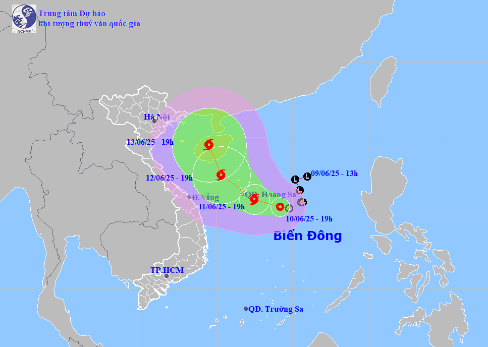
According to the National Center for Hydro-Meteorological Forecasting, on the afternoon of June 10, the tropical depression was located about 360 km east-southeast of the Hoang Sa archipelago. The strongest wind speed was level 6-7 (maximum 61 km/h), gusting to level 9.
It is forecasted that on June 11, the tropical depression will likely strengthen into a storm, with winds of level 8, gusts of level 10, and move west-northwest at a speed of 5-10 km/h. By 1:00 p.m. on June 12, the storm will continue to strengthen to level 9, gusts will increase by 2 levels, maintaining the same direction but increasing speed to about 10 km/h.
The Japan Meteorological Agency also said that the tropical depression will strengthen into a storm and continue moving northwest, towards Hainan Island (China).
Deputy Director of the National Center for Hydro-Meteorological Forecasting Hoang Phuc Lam said that with the current developments, the low pressure area is likely to cause widespread heavy rain in the central region.
During the day and night of June 11, the South Central region will have widespread rain of 30 - 80 mm, with some places having over 150 mm. From the night of June 11 to June 13, the area from Quang Binh to Quang Ngai will have widespread rain of 100 - 300 mm, with some places exceeding 450 mm. The Northern Central Highlands will have widespread rain of 70 - 150 mm, with some places having over 150 mm.
Mr. Lam warned of the risk of extreme heavy rain, which could reach more than 200 mm in just 6 hours.
In addition to heavy rain, the tropical depression also causes strong winds of level 6 - 7, later increasing to level 8, gusting to level 11 in the northern East Sea (including the waters of the Hoang Sa archipelago) and the northern area of the central East Sea. The offshore waters from Quang Tri to Quang Ngai and the Gulf of Tonkin are likely to experience strong winds of level 7, in some places level 8, gusting to level 10; waves of 3 - 5 meters high.
In the face of complicated weather developments, on the afternoon of June 10, the Ministry of Agriculture and Environment issued an urgent dispatch, requesting the provinces in the Central, Central Highlands and Southern regions to proactively deploy plans to respond to heavy rains, flash floods and landslides. Localities should review vulnerable areas, organize guarding, warn people in high-risk areas and prepare rescue vehicles and forces when necessary.
The first tropical depression in 2025 appeared on February 12 but did not strengthen into a storm.
The meteorological agency forecasts that from now until August 2025, there will be about 5 storms or tropical depressions active in the East Sea, of which about 2 are likely to directly affect mainland Vietnam.
PV (synthesis)Source: https://baohaiduong.vn/ap-thap-nhiet-doi-se-manh-len-thanh-bao-gay-mua-lon-o-trung-bo-tu-ngay-11-6-413739.html

![[Photo] President Luong Cuong talks on the phone with South Korean President Lee Jae Myung](https://vphoto.vietnam.vn/thumb/1200x675/vietnam/resource/IMAGE/2025/6/13/eee54a4c903f49bda277272b1dda68e8)


Comment (0)