
 |
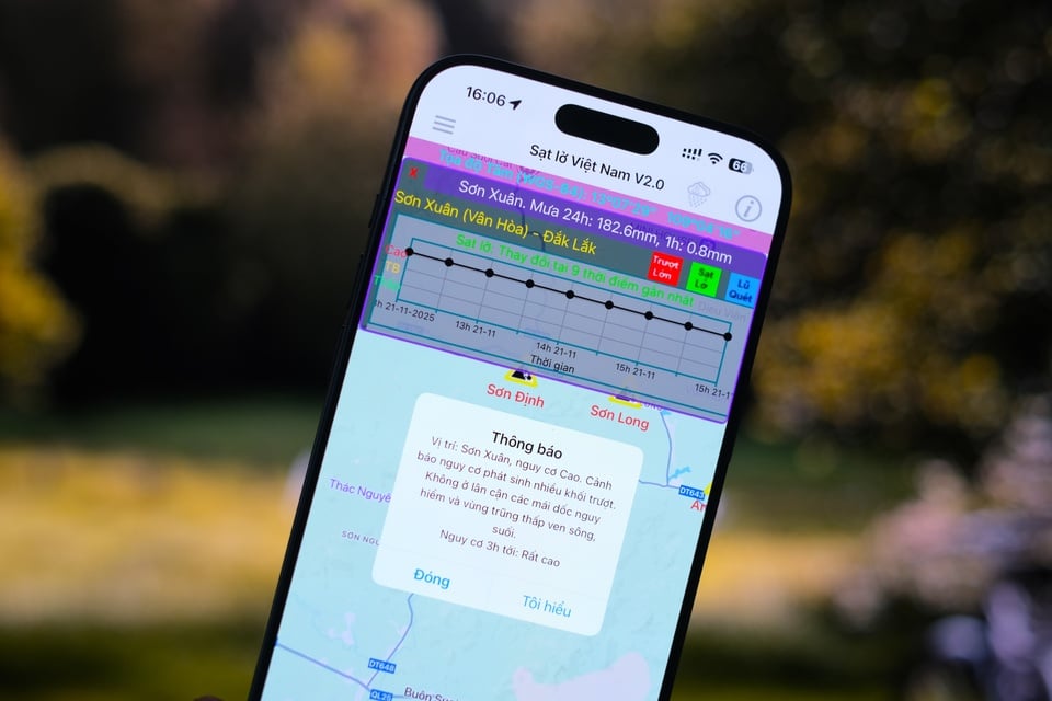
Vietnam Landslide application interface. Photo: Tuan Anh . |
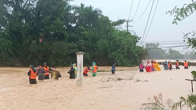
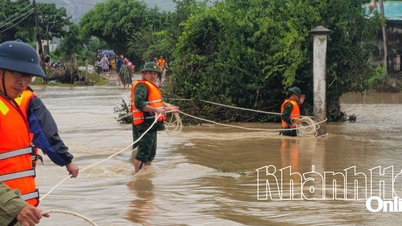
Landslide and flash flood warnings have become a matter of survival for both residents and authorities during stormy days. In just a few hours, large chunks of earth can collapse from mountain slopes, sweeping away houses, roads and property, leaving behind severe consequences.
Faced with that situation, the research team of Prof. Dr. Do Minh Duc at the University of Science - Vietnam National University, Hanoi has developed an application to provide real-time warning information.
The “Vietnam Landslides” application, which can be downloaded on Android and iOS, is forecasted based on AI, Internet of Things and Big Data monitoring. This is the first solution in Vietnam capable of monitoring and warning of landslides and flash floods in real time, contributing to enhancing the ability to prevent and reduce natural disaster risks.
 |
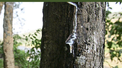
Mimosa Pass ( Lam Dong ) was broken in half after a long rain on the night of November 19. Photo: Minh Ha/Da Lat Cham . |
3 levels of risk to help prevent in time
Landslides often occur very quickly and in small areas, especially in the mountainous areas of Vietnam with complex terrain, many steep slopes and narrow valleys. Developing a specialized warning system is a big challenge, even for many developed countries.
Sharing on the website of Hanoi National University, Prof. Dr. Do Minh Duc said that "Vietnam Landslide" warns of 4 main types of natural disasters, including landslides, flash floods, large-scale landslides and extreme heavy rain. Data is updated every 20 minutes, displaying details down to the village, hamlet or commune level. Users can set the warning radius.
Regarding the risk of landslides and flash floods, the application divides them into 3 levels. At the Medium level, small, local landslides may occur. People need to increase vigilance, especially on slopes higher than 6m, newly dug slopes or slopes that have shown signs of sliding.
 |
Prof. Dr. Do Minh Duc, Head of the Department of Geotechnical Engineering and Infrastructure Development, Faculty of Geology, chaired the application development project "Landslides in Vietnam". Photo: University of Science, Vietnam National University, Hanoi . |
When the risk is High, the possibility of landslides and flash floods is very high. People need to activate response plans, avoid low-lying areas, along streams or high slopes, slopes over 45 degrees. At the same time, limit movement through these places, because landslides can continue from 3-6 hours after the rain stops.
At Very High, landslides or flash floods have occurred or are occurring, possibly on a large scale. Evacuation is required immediately and people should absolutely not enter the danger areas. The risk may last 6-12 hours or longer, even after the rain has stopped.
When actual rainfall exceeds multiple thresholds such as 60mm/hour, 90-100mm/3 hours or 110-120mm/6 hours, the risk of landslides and flash floods increases sharply. Users entering dangerous areas will receive audio warnings from the application, with the frequency changing depending on whether they are moving or standing still.
Safety begins with early warning
In addition to warnings, the application also stores large data on areas where landslides have occurred, helping to forecast trends over time and support residential planning, traffic, irrigation or resettlement in mountainous and midland areas with complex terrain.
The experts advise people to be vigilant when the risk of landslides is High or Very High, especially on slopes with cracks. During heavy rains, regularly check streams and small streams and treat or avoid the area if blockages are found.
 |
Instructions for use and interpretation of symbols. Photo: Hanoi National University. |
Residents should monitor rainfall within a 3-5 km radius and check water flows every 30-60 minutes. If the rain continues but the water level does not rise, they should immediately move to higher ground 5-6 m. Severe damage often occurs during prolonged periods of rain, which repeatedly exceed the warning level, and flash floods can occur even after the rain has stopped, so wait for the all-clear before returning to the area.
“Natural disasters are caused by the heavens, but the damage caused by natural disasters depends on human behavior. When each person can access technology and proactively monitor warnings, we have gone a long way in protecting ourselves, our families and our communities,” shared Prof. Dr. Do Minh Duc.
Currently, users can download the “Vietnam Landslide” application for free on CH Play and App Store to receive landslide and flash flood warnings. After installation, the first time opening the application will ask the user to allow access to the device location so that the system can send warnings.
The research team hopes to continue to maintain, upgrade and provide the application for free for many years to come, contributing to reducing natural disaster risks for the community.
Source: https://znews.vn/app-canh-bao-moi-vi-tri-sat-lo-lu-quet-nguy-hiem-post1604668.html
![[Photo] General Secretary To Lam receives President of the Senate of the Czech Republic Milos Vystrcil](/_next/image?url=https%3A%2F%2Fvphoto.vietnam.vn%2Fthumb%2F1200x675%2Fvietnam%2Fresource%2FIMAGE%2F2025%2F11%2F21%2F1763723946294_ndo_br_1-8401-jpg.webp&w=3840&q=75)
![[Photo] National Assembly Chairman Tran Thanh Man holds talks with President of the Senate of the Czech Republic Milos Vystrcil](/_next/image?url=https%3A%2F%2Fvphoto.vietnam.vn%2Fthumb%2F1200x675%2Fvietnam%2Fresource%2FIMAGE%2F2025%2F11%2F21%2F1763715853195_ndo_br_bnd-6440-jpg.webp&w=3840&q=75)
![[Photo] Visit Hung Yen to admire the "wooden masterpiece" pagoda in the heart of the Northern Delta](/_next/image?url=https%3A%2F%2Fvphoto.vietnam.vn%2Fthumb%2F1200x675%2Fvietnam%2Fresource%2FIMAGE%2F2025%2F11%2F21%2F1763716446000_a1-bnd-8471-1769-jpg.webp&w=3840&q=75)


![[Photo] President Luong Cuong receives Speaker of the Korean National Assembly Woo Won Shik](/_next/image?url=https%3A%2F%2Fvphoto.vietnam.vn%2Fthumb%2F1200x675%2Fvietnam%2Fresource%2FIMAGE%2F2025%2F11%2F21%2F1763720046458_ndo_br_1-jpg.webp&w=3840&q=75)


Comment (0)