
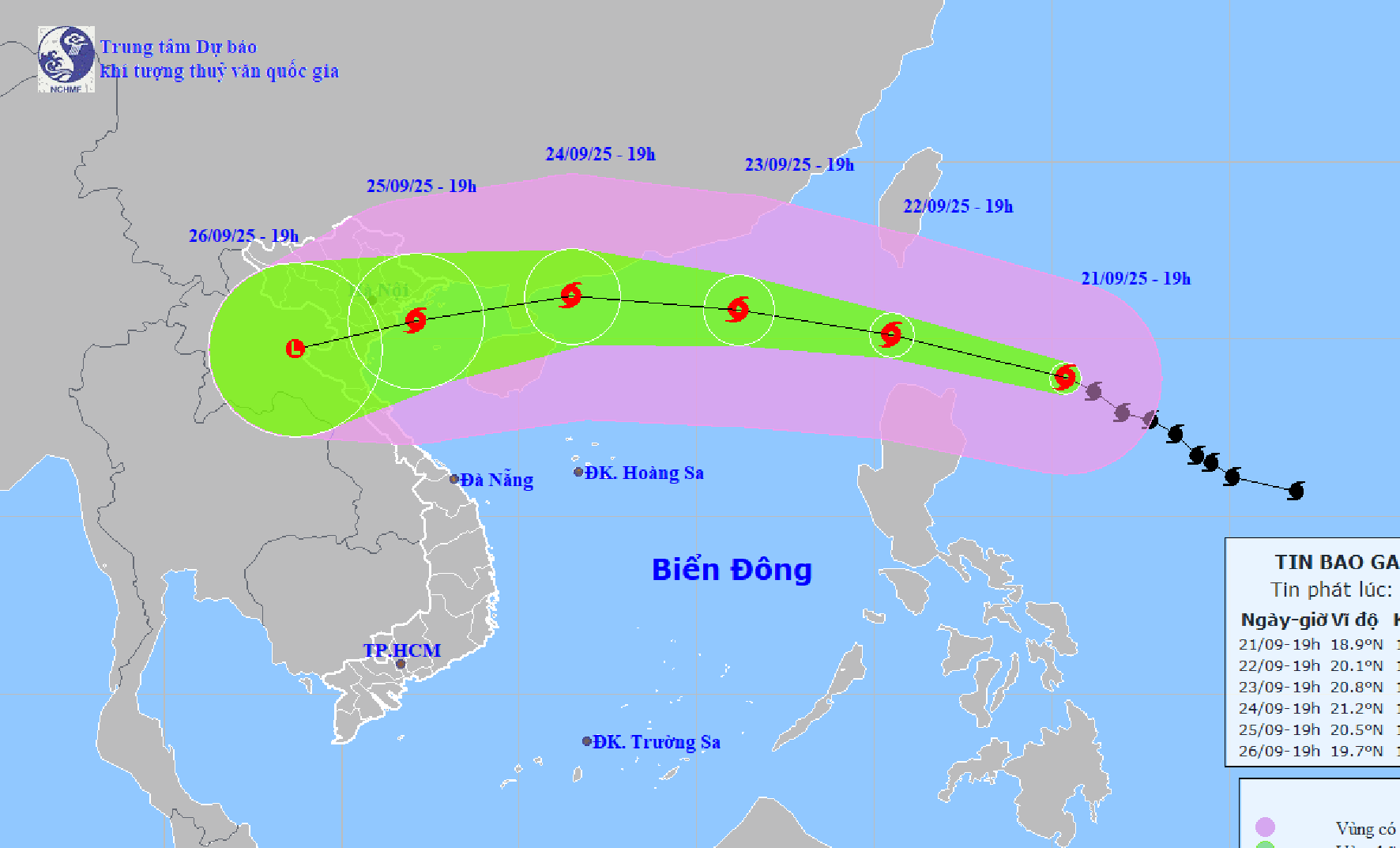
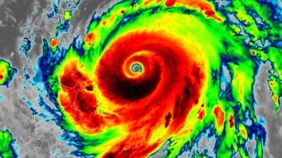
According to the National Center for Hydro-Meteorological Forecasting, at 7:00 p.m. on September 21, the center of super typhoon Ragasa was at about 18.9 degrees north latitude; 125.4 degrees east longitude, about 350km east of Luzon Island (Philippines). The strongest wind near the center of the storm was level 16 - 17 (184 - 221km/h), gusting above level 17. The storm moved northwest at a speed of 15 - 20km/h.
At 7:00 p.m. on September 22, the center of Ragasa storm was at about 20.1 degrees north latitude; 120.5 degrees east longitude, about 120km northwest of Lu Dong island. The storm intensity was level 17, gusting above level 17.
Due to the storm's influence, from September 22, the northeastern sea area of the East Sea will have winds gradually increasing to level 8 - 9, then increasing to level 10 - 14. The area near the center of the super storm will have winds of level 15 - 17, gusts above level 17, waves over 10m high, and rough seas. Ships in the danger zone are likely to be affected by storms, whirlwinds, very strong winds, and very large waves.
Dr. Hoang Phuc Lam, Deputy Director of the National Center for Hydro-Meteorological Forecasting, said that around the evening of September 22, super typhoon Ragasa will move into the East Sea and become the 9th typhoon in the 2025 typhoon season. After that, the typhoon will move quickly, about 20km/h, the maximum intensity of the typhoon can reach level 16 - 17, gusting above level 17 on September 22 - 23 while still in the East Sea. "This is a strong intensity equivalent to the strongest intensity of typhoon No. 3 ( Yagi ) in 2024," Mr. Lam commented.
On September 24, storm Ragasa is likely to weaken. By early morning on September 25, the storm will pass the Leizhou peninsula (China) and move into the Gulf of Tonkin with a strong intensity of level 12 - 14, gusting to level 15 - 16. "On September 25, storm Ragasa will move inland, focusing on the area from Quang Ninh - Ha Tinh ", Mr. Lam commented.
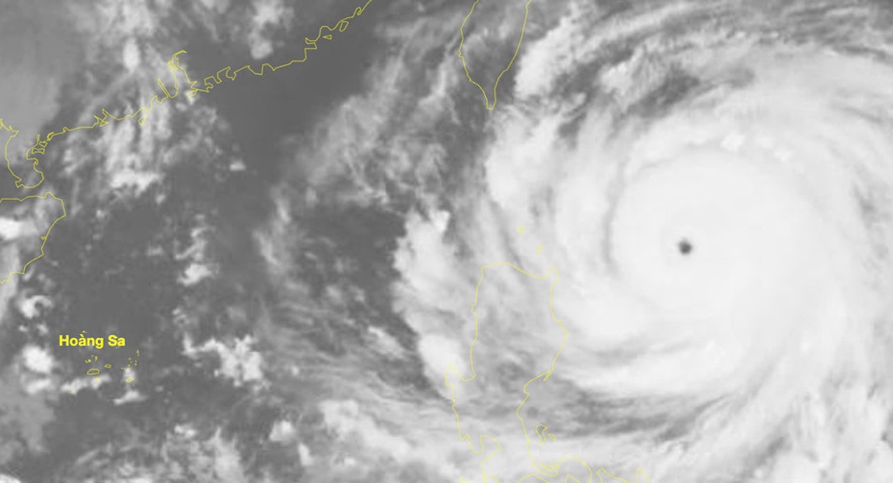
According to Dr. Hoang Phuc Lam, in the past 2-3 days, most models and storm forecasting centers of the world and Vietnam have simulated this as a storm with a very wide circulation, very strong intensity when operating in the East Sea, reaching super typhoon level, strongest between September 22-23.
By September 24, when moving to the sea area south of Guangdong province (China), due to the storm's northern circulation being affected by terrain friction, it is forecast to weaken and when entering the Gulf of Tonkin, the storm's intensity will decrease by 2-4 levels compared to when it was still offshore.
However, Mr. Lam emphasized that it is necessary to note that a worse scenario is still possible. That is, when entering the East Sea, the storm will move mainly in a westerly direction, the lower the storm trajectory, the less the storm intensity will be reduced, the impact of strong winds and large waves in the Gulf of Tonkin will be higher.
Hai Phong proactively responds to storm Ragasa
Implementing the direction of the National Civil Defense Steering Committee, the Hai Phong City Civil Defense Command requested the Steering Committee for Natural Disaster Prevention, Search and Rescue and Civil Defense of localities, sectors, agencies and units to closely monitor warning bulletins, forecasts and developments of the storm; notify captains and owners of vehicles and vessels operating at sea to proactively prevent, have production plans, ensure safety of people and property; maintain communication to promptly handle bad situations that may occur. Prepare forces and means to deploy rescue work when situations arise.
Hai Phong Newspaper, Radio and Television, Hai Phong Coastal Information Station and mass media agencies, local radio and broadcasting systems should increase information about the developments of storm Ragasa to local authorities, owners of vehicles operating at sea and people to proactively prevent and respond.
Source: https://baohaiphong.vn/bao-ragasa-se-anh-huong-den-dat-lien-cac-tinh-tu-quang-ninh-ha-tinh-521433.html

![[Photo] Prime Minister Pham Minh Chinh chairs the 14th meeting of the Steering Committee on IUU](https://vphoto.vietnam.vn/thumb/1200x675/vietnam/resource/IMAGE/2025/9/23/a5244e94b6dd49b3b52bbb92201c6986)


![[Photo] Editor-in-Chief of Nhan Dan Newspaper Le Quoc Minh received the working delegation of Pasaxon Newspaper](https://vphoto.vietnam.vn/thumb/1200x675/vietnam/resource/IMAGE/2025/9/23/da79369d8d2849318c3fe8e792f4ce16)


Comment (0)