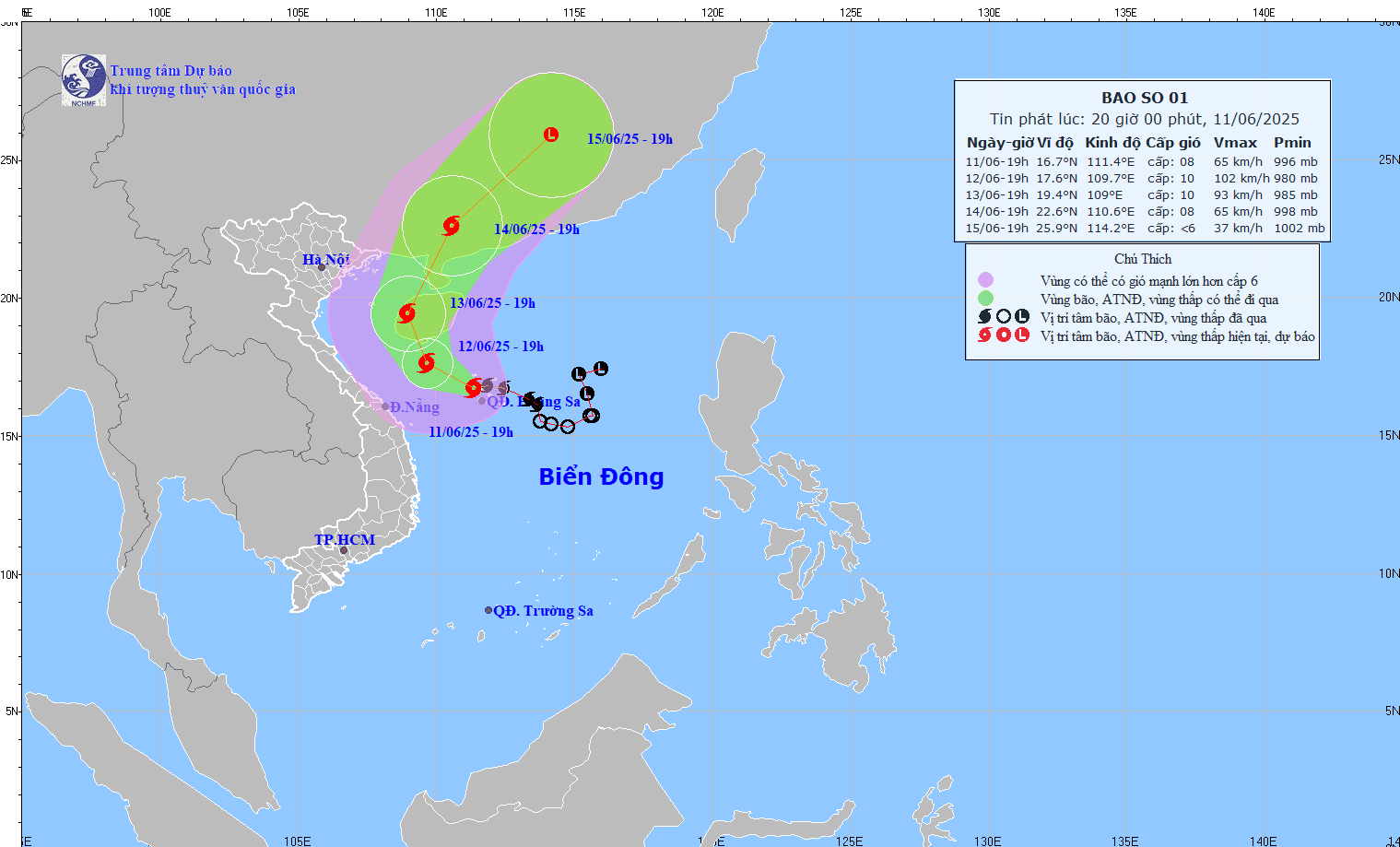
According to the National Center for Hydro-Meteorological Forecasting, storm No. 1 with gusts of level 13 is heading towards the sea south of China's Hainan Island.
At 7:00 p.m. on June 11, the center of storm No. 1 was at about 16.7 degrees North latitude; 111.4 degrees East longitude, in the Hoang Sa archipelago. The strongest wind near the center of the storm reached level 8 (62–74 km/h), gusting to level 10. The storm moved in a West-Northwest direction at a speed of about 15 km/h.
In the next 24 to 72 hours, the storm will continue to move in the West-Northwest direction and then North-Northwest, then change direction to North-Northeast and gradually weaken.

Forecast at 7pm on June 12, the storm center is at about 17.6°N - 109.7°E, in the sea south of Hainan Island (China). Strong winds level 10, gusts level 13.
At 7 p.m. on June 13, the storm was at about 19.4°N - 109.0°E, west of China's Hainan Island. Winds were level 9-10, gusting to level 13.
At 7:00 p.m. on June 14, the storm moved into mainland southern China, at about 22.6°N - 110.6°E, weakening to level 8, gusting to level 10. From the next 72 to 96 hours, the storm will move northeast at a speed of about 20 km/h and continue to weaken.
Warning of strong winds, high waves and heavy rain at sea, in the Northwest of the East Sea (including Hoang Sa archipelago): Strong winds level 7-8, near the storm center level 9-10, gusting to level 13. Waves are 3.0-5.0m high, near the storm center 4.0-6.0m. Very rough seas.
From the night of June 11, the offshore sea area from Quang Tri to Quang Ngai will gradually increase to level 6-8, near the storm center level 9-10, gusting to level 13.
From June 12, the Gulf of Tonkin will have strong winds of level 6-7, near the storm center, level 8-9, gusting to level 11. Waves are 2.0-4.0m high. Rough seas.
On land, from the evening of June 11 to June 13, the Central Central region will have heavy to very heavy rain, with rainfall ranging from 100-250 mm, with some places experiencing over 450 mm. The Northern Central Highlands will have moderate rain, heavy rain and thunderstorms, with some places experiencing very heavy rain with rainfall ranging from 70-150 mm, with some places experiencing over 200 mm.
The Meteorological Center assessed the level of natural disaster risk due to storms as level 3 in the northwestern area of the East Sea (including the Hoang Sa archipelago), offshore waters from Quang Tri to Quang Ngai and the Gulf of Tonkin. Ships operating in the danger zone are likely to be affected by thunderstorms, tornadoes, strong winds and large waves.
Source: https://baolaocai.vn/bao-so-1-giat-cap-10-va-tiep-tuc-tang-len-cap-13-tren-bien-dong-post403169.html


Comment (0)