
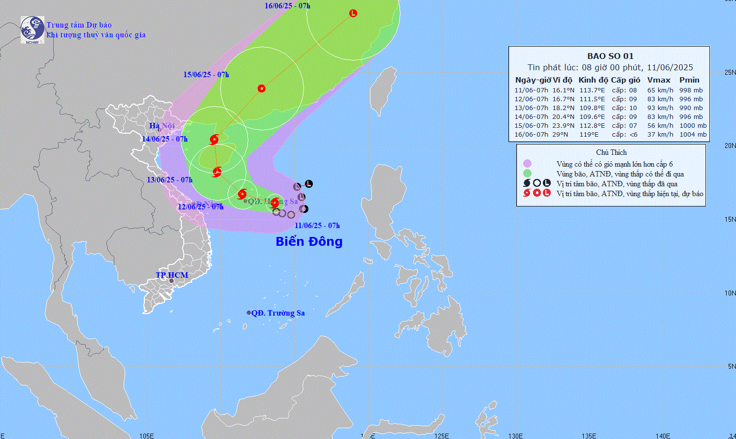
The movement of storm No. 1 at 8:00 a.m. on June 11. Photo: Nchmf
The National Center for Hydro-Meteorological Forecasting said that the tropical depression in the East Sea has strengthened into a storm, the first storm of 2025, with the international name Wutip. At 7:00 a.m. this morning (June 11), the center of the storm was located in the sea east of the Hoang Sa archipelago; the wind near the center of the storm was strong at level 8, gusting to level 10. The storm is currently moving slowly in the West-Northwest direction at a speed of about 5-10 km/h. In the next 72 hours, the storm will continue to strengthen and move towards the south of Hainan Island (China), reaching a maximum intensity of level 10, gusting to level 13.
Due to the storm's influence, the northern and central areas of the East Sea, including the Hoang Sa archipelago, will experience strong thunderstorms, winds of level 6-7, near the storm's center of level 8-9, gusts of level 11; waves 3-5m high, very rough seas.
On land from the afternoon of June 11 to June 13, provinces and cities from Hue to Phu Yen , the North Central Highlands, the South Central Coast and the South continued to experience widespread heavy rain. Total rainfall in the Central Central region was generally 100-300mm, with some places higher than 450mm; the North Central Highlands 70-150mm, with some places higher than 200mm... Heavy rain concentrated in a short period of time also poses the risk of flash floods and landslides in mountainous areas and flooding in low-lying areas, urban areas and industrial parks.
In response to the above forecast, the Ministry of Agriculture and Environment requested provinces and cities from Quang Tri to Phu Yen, the Central Highlands and the South to immediately deploy plans to ensure safety for boats, evacuate people from high-risk areas, and review areas prone to landslides and flooding. At the same time, functional forces need to organize 24/7 duty, closely monitor meteorological bulletins, promptly issue warnings to people; coordinate with the transport, health, and industry and trade sectors to respond when bad situations occur.
Source: https://baotuyenquang.com.vn/bao-so-1-manh-cap-10-giat-cap-13-gay-mua-lon-tren-dat-lien-213285.html


Comment (0)