
The National Center for Hydro-Meteorological Forecasting said that at 10:00 a.m. on June 13, storm No. 1 was in the sea southwest of Hainan Island (China). The strongest wind near the storm's center was level 11 (103-117 km/h), gusting to level 14. The storm moved northwest at a speed of 10-15 km/h.
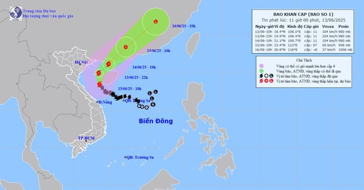
Forecast map of the trajectory and intensity of storm No. 1 at 11:00 a.m. on June 13. (Source: NCHMF)
The above storm level is forecast to remain in place for the next 24 hours. At around 10am on June 14, storm No. 1 in the Leizhou Peninsula (China) continued to move in a north-northwest direction after turning north-northeast, traveling about 10-15km per hour.
At around 10am on June 15, storm No. 1 in the southwestern part of Guangdong province (China) moved in a north-northeast direction, traveling about 15km per hour, and gradually weakened into a tropical depression. The strongest wind near the storm's center was at level 7, gusting to level 9.
At 10:00 a.m. on June 16, a tropical depression over southern China moved northeast at a speed of 20-25 km/h and gradually weakened into a low pressure area.
The circulation of storm No. 1 causes continuous heavy rain to fall on the provinces and cities of the Central region. Today (June 13), it is forecasted that from Quang Binh to Hue, there will be heavy to very heavy rain with common rainfall of 50-120mm, some places over 250mm. Southern Nghe An, Ha Tinh, from Da Nang to Quang Nam and Kon Tum, there will be moderate rain, heavy rain, locally very heavy rain and thunderstorms with rainfall ranging from 20-40mm, some places over 120mm. There is a risk of localized heavy rain over 120mm in just 6 hours.
Continuous heavy rain for many hours, soil moisture model shows that some areas in the Central and Central Highlands provinces are nearly saturated (over 85%) or have reached saturation. In the coming hours, there is a high/very high risk of flash floods on small rivers and streams, landslides on steep slopes in many districts of 7 provinces and cities in the Central region ( Ha Tinh , Quang Binh, Quang Tri, Hue, Da Nang, Quang Nam, Quang Ngai) and Kon Tum province.
Also according to the meteorological agency, the flood on the Huong River is rising. The water level at 7am on June 13, on the Huong River at Kim Long was 2.14m, above alert level 2 (BĐ2) by 0.14m. Forecast In the next 6 hours, the flood on the Huong River will continue to rise and peak, then gradually decrease. In the next 6-24 hours, the flood on the Huong River will gradually decrease and be at level BĐ1. Beware of localized flooding in low-lying areas along the river and urban areas of Hue City.
In addition, due to the impact of storm No. 1 Wutip, the sea area of Bac Bo Gulf (including Co To and Bach Long Vi island districts) has strong winds of level 7-8, the area near the storm's center has winds of level 9-11, gusts of level 14, waves 2-4m high; in which the East has waves of 3-5m, with rough seas.
Northwest of the North East Sea and offshore waters from Quang Tri to Da Nang, strong winds level 6-8, near the storm center level 9-11, gusts level 14, waves 3-5m high, near the storm center 4-6m high, rough seas.
According to vtcnews.vn
Source: https://baothanhhoa.vn/bao-so-1-manh-len-cap-11-loat-tinh-mien-trung-nguy-co-sat-lo-252015.htm


Comment (0)