

According to the National Center for Meteorological and Hydrological Forecasting, last night (October 22), Typhoon No. 12 weakened into a tropical depression while moving into the central coastal waters.
As of 1 AM this morning (October 23), the center of the tropical depression is located over the sea from southern Quang Tri to Quang Ngai, about 80km east-northeast of Da Nang city. The strongest winds near the center of the tropical depression are at level 6 (39-49 km/h), with gusts up to level 8. Currently, the tropical depression is still moving steadily southwest at a speed of 10-15 km/h.
The National Center for Meteorological and Hydrological Forecasting predicts that the tropical depression will move inland this morning and afternoon. By 1 PM, the center of the tropical depression will be over land in the area from Da Nang City to Quang Ngai province and will continue to weaken gradually into a low-pressure area, with wind intensity decreasing below level 6.
According to the forecast model of the Joint Typhoon Warning Center (JTWC - USA), at around 7 a.m. this morning (Vietnam time), the center of the tropical depression was still about 40-60km from the coast of Hue - Da Nang.
, updated at nearly 7 AM this morning.")
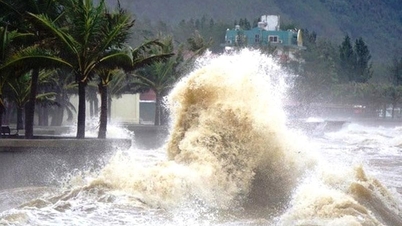
The meteorological agency warns that today, due to the influence of a tropical depression combined with a cold front, the sea area from Quang Tri to Quang Ngai (including Con Co Special Economic Zone, Cu Lao Cham Island and Ly Son Special Economic Zone) will experience strong winds of level 6, gusting to level 8.
Coastal areas from southern Quang Tri to Da Nang City will experience storm surges of 0.3-0.6m due to strong winds. Coastal and estuary areas from southern Quang Tri to Da Nang need to be wary of large waves combined with high tides and storm surges causing flooding in low-lying areas, waves overflowing coastal and riverside roads, and coastal erosion. All ships, boats, and aquaculture farms in the aforementioned danger zone are at risk from thunderstorms, tornadoes, strong winds, large waves, and storm surges.
The National Center for Meteorological and Hydrological Forecasting continues to warn of the risk of rain and floods due to the circulation of the storm (tropical depression). From today until the night of October 24th, the area from Ha Tinh to Quang Ngai will experience heavy rain, with the heaviest rainfall concentrated from southern Quang Tri to Da Nang, with amounts of 200-400mm, and in some places over 700mm.
Source: https://www.sggp.org.vn/bao-so-12-da-suy-yeu-thanh-ap-thap-nhiet-doi-post819429.html


![[Photo] The heat at the fireworks display site on the opening night of the Da Nang International Fireworks Festival 2026](https://vphoto.vietnam.vn/thumb/1200x675/vietnam/resource/IMAGE/2026/05/27/1779889741485_ndo_br_z7872039145157-fecaba5112f39e8352544099d7ef4738-5140-jpg.webp)

![[Photo] The courage of new recruits of Brigade 144 on the training ground.](https://vphoto.vietnam.vn/thumb/1200x675/vietnam/resource/IMAGE/2026/05/27/1779881651341_anh-man-hinh-2026-05-27-luc-18-32-52.png)


![[Photo] The courage of new recruits of Brigade 144 on the training ground.](https://vphoto.vietnam.vn/thumb/402x226/vietnam/resource/IMAGE/2026/05/27/1779881651341_anh-man-hinh-2026-05-27-luc-18-32-52.png)


Comment (0)