

The path of storm No. 3 seen from satellite (Photo: VNA)
According to the National Center for Hydro-Meteorological Forecasting, due to the impact of storm No. 3 (storm Wipha), in Bach Long Vi special zone, there were strong winds of level 8, gusting to level 9; in Co To and Cat Ba special zones (Cat Hai special zone), there were strong winds of level 6, gusting to level 7.
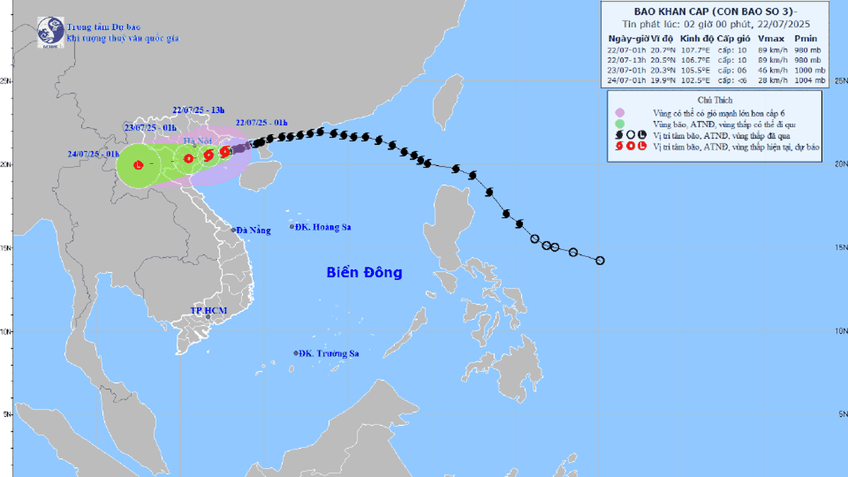
At 4:00 p.m. on July 21, 2025, the center of the storm was at approximately 20.9 degrees North latitude; 108.7 degrees East longitude, approximately 100km from Quang Ninh, 220km from Hai Phong ; approximately 240km from Hung Yen, approximately 270km from Ninh Binh.
The strongest wind near the storm center is level 9-10 (75-102km/h), gusting to level 12; moving in the West Southwest direction at a speed of about 15km/h.
Forecast for the next 48 hours:
At 4:00 a.m. on July 22: Storm in the northern Gulf of Tonkin (20.7°N; 107.6°E), level 10–11, gust level 14, likely to strengthen.
At 4:00 p.m. on July 22: Storm on the mainland along the coast of Hai Phong - Thanh Hoa (20.4°N; 106.3°E), level 9-10, gust level 13.
At 4:00 p.m. on July 23: The storm is in the Upper Laos region (19.9°N; 103.7°E), weakening into a low pressure area.
Marine weather forecast:
Northern Gulf of Tonkin (Bach Long Vi, Co To, Van Don, Cat Hai, Hon Dau): wind level 6-7, increasing to level 8-9, near the storm center level 10-11, gusting to level 14; waves 2.0-4.0m high, near the center 4.0-6.0m; rough seas.
Southern Bac Bo Gulf (Hon Ngu): wind level 6-7, near the storm center level 8-9, gust level 11; waves 2.0-4.0m high; very rough seas.
Storm surge warning for coastal areas from Hung Yen to Quang Ninh: 0.5-1.0m high. Ba Lat: 2.4-2.6m Hon Dau: 3.9-4.3m Cua Ong: 4.6-5.0m Tra Co: 3.6-4.0m.
Risk of flooding in coastal and estuary areas on the afternoon of July 22.
Dangerous weather at sea and inshore. Unsafe for cruise ships, passenger ships, transport, cages, aquaculture areas, dykes, coastal works.
On land:
- From the night of July 21, winds will gradually increase to level 7-9, near the storm center level 10-11, gusting to level 14 on the coast of Quang Ninh-Nghe An. Hai Phong, Hung Yen, Bac Ninh, Hanoi, Ninh Binh, Thanh Hoa will have winds of level 6, gusting to level 7-8. Winds of level 10-11 can cause trees, electric poles, and roofs to fall. 5. Heavy rain is forecast.
- From the evening of July 21-23: Northeast, Northern Delta, Thanh Hoa, Nghe An: heavy - very heavy rain, generally 200-350mm, some places over 600mm. Other places in the North and Ha Tinh: rain 100-200mm, some places over 300mm. Risk of heavy rain with high intensity >150mm/3 hours. Warning of flash floods, landslides, flooding in low-lying areas./.
According to Vietnam+
Source: https://www.vietnamplus.vn/bao-so-3-dao-bach-long-vi-da-co-gio-manh-cap-8-giat-cap-9-post1050884.vnp
Source: https://baolongan.vn/bao-so-3-dao-bach-long-vi-da-co-gio-manh-cap-8-giat-cap-9-a199171.html


![[Photo] National Assembly Chairman Tran Thanh Man visits Vietnamese Heroic Mother Ta Thi Tran](https://vphoto.vietnam.vn/thumb/1200x675/vietnam/resource/IMAGE/2025/7/20/765c0bd057dd44ad83ab89fe0255b783)


Comment (0)