
 |
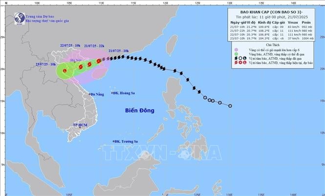
| The movement of storm No. 3 at 1:00 p.m. on July 21. Photo: VNA |
According to the National Center for Hydro-Meteorological Forecasting, at 1:00 p.m. on July 21, the center of the storm was located at approximately 21.1 degrees North latitude; 109.1 degrees East longitude, approximately 120km from Quang Ninh, 260km East of Hai Phong ; approximately 280km from Hung Yen, approximately 310km East Northeast of Ninh Binh. The strongest wind near the center of the storm is level 9-10 (75-102km/h), gusting to level 12; moving West Southwest at a speed of 10-15km/h.
At 1:00 a.m. on July 22, the storm moved in a West-Southwest direction over the Northern Gulf of Tonkin at a speed of about 10-15 km/h and was likely to strengthen. The strongest wind was level 10-11, gusting to level 14. The affected areas were the Northwestern sea area of the North East Sea, the Gulf of Tonkin, the Gulf of Tonkin, and coastal waters of provinces and cities from Quang Ninh to Ninh Binh . Disaster risk level 3.
At 1:00 p.m. on July 22, the storm moved in a West-Southwest direction, over the sea from Hai Phong to Thanh Hoa at a speed of about 10-15 km/h. The strongest wind is level 10-11, gusting to level 14. The affected areas are the Gulf of Tonkin, coastal waters and mainland provinces and cities from Quang Ninh to Nghe An . Disaster risk level 3.
At 1 p.m. on July 23, the storm moved west-southwest over the mainland of Upper Laos at a speed of about 10-15 km/h and gradually weakened into a low-pressure area. Wind force below level 6. The affected areas are the Gulf of Tonkin, coastal waters and mainland provinces and cities from Quang Ninh to Nghe An. Disaster risk level 3.
Due to the influence of the storm, the northwestern sea area of the North East Sea has strong winds of level 7-8, gusts of level 10, waves 3-5m high, rough seas. The northern sea area of the Gulf of Tonkin (including the special zones of Bach Long Vi, Co To, Van Don, Cat Hai, Hon Dau island) has strong winds of level 6-7, then increasing to level 8-9, the area near the storm's eye has winds of level 10-11, gusts of level 14, waves 2-4m high, the area near the storm's eye has winds of 4-6m, rough seas. The southern sea area of the Gulf of Tonkin (including Hon Ngu island) has winds gradually increasing to level 6-7, the area near the storm's eye has winds of level 8-9, gusts of level 11, waves 2-4m high, rough seas.
Due to the impact of the storm, the coastal areas of Hung Yen - Quang Ninh have storm surges of 0.5-1m. The water level in Ba Lat ( Hung Yen ) is 2.4-2.6m high, Hon Dau (Hai Phong) is 3.9-4.3m high, in Cua Ong (Quang Ninh) is 4.6-5m high and in Tra Co (Quang Ninh) is 3.6-4m high. There is a high risk of flooding in coastal areas and river mouths on the afternoon of July 22.
Hydrological experts warn: The weather at sea and in coastal areas during the storm is extremely dangerous, unsafe for any means of transport or construction operating in the danger zone such as: tourist boats, passenger ships, transport ships, cages, rafts, aquaculture areas, dykes, embankments, coastal routes. Vehicles are highly likely to capsize, be destroyed, or be flooded due to strong winds, storms, whirlwinds, large waves, and rising sea levels. Level 10-11 winds can knock down trees, electric poles, and blow off roofs, causing very heavy damage.
On land, from the evening and night of July 21, coastal areas from Quang Ninh to Nghe An will have winds gradually increasing to level 7-9, near the storm center level 10-11, gusting to level 14; inland areas of Hai Phong, Hung Yen, Ninh Binh and Thanh Hoa provinces/cities, strong winds of level 6, gusting to level 7-8.
In addition, from July 21 to July 23, the Northeast region, the Northern Delta, Thanh Hoa and Nghe An will have heavy to very heavy rain and thunderstorms with common rainfall of 200-350mm, locally over 600mm; other places in the Northern region and Ha Tinh will have moderate rain, heavy rain, locally very heavy rain and thunderstorms with common rainfall of 100-200mm, locally over 300mm. Warning of the risk of heavy rain over 150mm in 3 hours. Heavy rain in a short period of time can cause flash floods, landslides in mountainous areas, and flooding in low-lying areas.
According to VNA
Source: https://baoapbac.vn/xa-hoi/202507/bao-so-3-gay-gio-manh-cap-8-giat-cap-9-tren-dao-bach-long-vi-va-cap-6-giat-cap-7-tren-dao-co-to-1047093/


![[Photo] National Assembly Chairman Tran Thanh Man visits Vietnamese Heroic Mother Ta Thi Tran](https://vphoto.vietnam.vn/thumb/1200x675/vietnam/resource/IMAGE/2025/7/20/765c0bd057dd44ad83ab89fe0255b783)


Comment (0)