
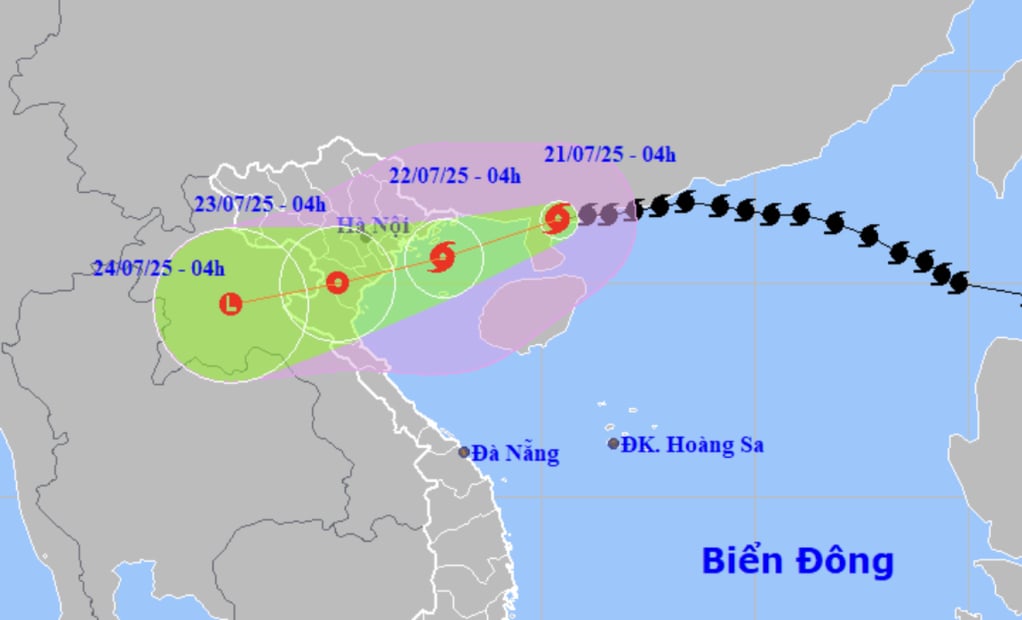
According to the National Center for Hydro-Meteorological Forecasting at 4:00 a.m. on July 21, the center of storm No. 3 was on the mainland north of Leizhou Peninsula (China), about 275km east of Quang Ninh - Hai Phong . The strongest wind near the center of the storm was level 9 (75-88km/h), gusting to level 11.
Thus, compared to 4:00 p.m. on July 20, the intensity of storm No. 3 has decreased by 3 levels because the storm has entered the mainland in the southwest of Guangdong province (China).
Storm No. 3 is likely to strengthen again in the Gulf of Tonkin
It is forecasted that from morning to noon today, storm number 3 will enter the Gulf of Tonkin and the storm winds are likely to become stronger again.
Specifically, in the next 24 hours, the storm is forecast to move west-southwest at a speed of 15km/h into the eastern sea of the northern Gulf of Tonkin and its intensity is likely to strengthen again.
At 4am tomorrow morning, the storm center will be in the northern Gulf of Tonkin, with a storm intensity of level 10-11 (89-117km/h), gusting to level 14.
During tomorrow day and night, the storm will continue to move west-southwest, then make landfall in the provinces of Hai Phong - Thanh Hoa and gradually weaken into a tropical depression.
At 4:00 a.m. on July 23, the center of the tropical depression was on land in Hung Yen - Thanh Hoa, the strongest wind near the center of the tropical depression was level 6-7, gusting to level 9.
The tropical depression then continued to move inland and weakened into a low pressure area over the upper Laos region.
Due to the influence of storm number 3, from today the northwest sea area of the North East Sea will have strong winds of level 7-8, near the storm center will have winds of level 9, gusts of level 11, waves 4-6m high, very rough seas.
The northern sea area of Bac Bo Gulf (including the special zones of Bach Long Vi, Co To, Cat Hai, Hon Dau island) has strong winds of level 6-7, then increasing to level 8-9, the area near the storm's eye has winds of level 10-11, gusting to level 14, waves 2-4m high, the area near the storm's eye has winds of 3-5m.
The southern Gulf of Tonkin (including Hon Ngu Island) has winds gradually increasing to level 6-7, near the storm center level 8-9, gusting to level 11, waves 2-4m high.
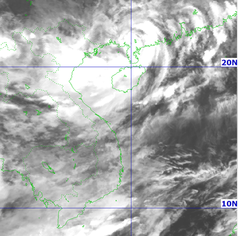
Satellite image of storm No. 3 at 4:00 a.m. on July 20 - Photo: NCHMF
From tonight, the wind along the coast of Quang Ninh - Nghe An will gradually get stronger.
The coastal areas of Hai Phong - Quang Ninh have storm surges of 0.5-1m high. The water level at Hon Dau (Hai Phong) is 3.7-4.1m high, at Cua Ong (Quang Ninh) is 4.4-4.8m high and at Tra Co (Quang Ninh) is 3.6-4m high. There is a high risk of flooding in coastal areas and river mouths on the afternoon of July 22.
"The weather at sea and in coastal areas during the storm is extremely dangerous and unsafe for any vehicles or structures operating in dangerous areas such as cruise ships, passenger ships, transport ships, cages, rafts, aquaculture areas, dykes, embankments, and coastal routes. Vehicles are at high risk of capsizing, being destroyed, or being flooded due to strong winds, storms, whirlwinds, large waves, and rising sea levels," the meteorological agency warned.
From the evening and night of July 21, coastal areas from Quang Ninh to Nghe An will have winds gradually increasing to level 7-9, areas near the storm center will have winds of level 10-11, gusting to level 14.
Inland areas, strong winds of level 6, gusting to level 7-8. Winds of level 10-11 (89-117km/h) can knock down trees, electric poles, and rip off roofs, causing very serious damage.
From today until July 23, in the Northeast region, the Northern Delta, Thanh Hoa and Nghe An, there will be heavy to very heavy rain and thunderstorms with common rainfall of 200-350mm, locally over 600mm.
Other places in the Northern region and Ha Tinh have moderate rain, heavy rain, locally very heavy rain and thunderstorms with common rainfall of 100-200mm, locally over 300mm.
Warning of the risk of heavy rain over 150mm in 3 hours causing flash floods, landslides in mountainous areas, and flooding in low-lying areas.
Source: https://baoquangninh.vn/bao-so-3-hom-nay-se-vao-vinh-bac-bo-tam-bao-dang-cach-quang-ninh-hai-phong-275-cay-so-3367636.html


![[Photo] National Assembly Chairman Tran Thanh Man visits Vietnamese Heroic Mother Ta Thi Tran](https://vphoto.vietnam.vn/thumb/1200x675/vietnam/resource/IMAGE/2025/7/20/765c0bd057dd44ad83ab89fe0255b783)


Comment (0)