At 7:00 a.m. this morning (July 18), the storm center was over the sea east of Luzon Island, Philippines, with the strongest wind near the storm center at level 8 (62-74 km/h), gusting to level 10.
World and domestic meteorological stations have similar assessments of the path of storm Wipha, according to which the storm will enter China's Leizhou peninsula and then affect the Gulf of Tonkin and northern Vietnam around July 22.
The latest assessments this morning show that this will be a very strong and dangerous storm in the East Sea when it passes through a warm sea area. The National Center for Hydro-Meteorological Forecasting said that the storm could reach level 11-12, gusting to level 15 when it approaches China's Leizhou Peninsula around July 21.
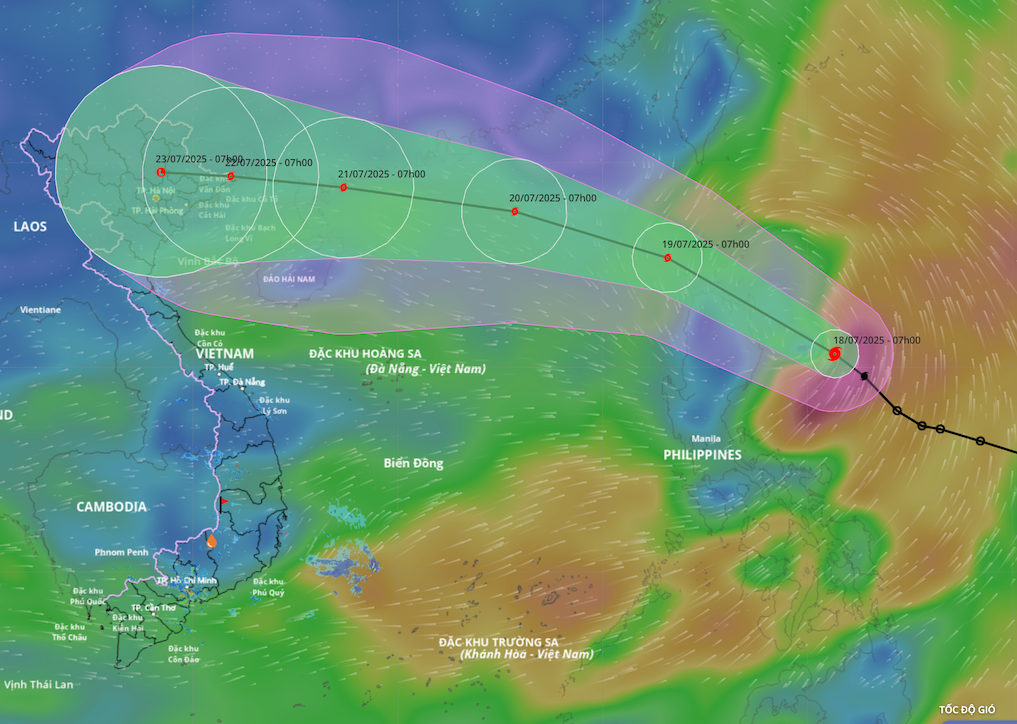
Specifically, in 24 hours (from 7:00 a.m. on July 18), the storm moved rapidly northwestward, traveling 20-25km per hour, entering the East Sea early in the morning of July 19 and continuing to strengthen.
At 7:00 a.m. on July 19, the storm center was in the northeastern sea of the North East Sea with a level 8-9 intensity, gusting to level 11.
In the next 24-48 hours, the storm will move rapidly in a west-northwest direction, about 20km per hour, and continue to strengthen.
At 7:00 a.m. on July 20, the storm's center was about 590 km east of China's Leizhou Peninsula. At this time, the storm reached level 10 intensity, with gusts of level 12.
In the next 48-72 hours, the storm will move steadily in a west-northwest direction, traveling about 20km per hour and will continue to strengthen. At 7am on July 21, the storm center was in the sea east of Leizhou Peninsula (China). The storm will strengthen to level 11-12, gusting to level 15.
From the next 72 to 120 hours, the storm will move mainly in a westerly direction, entering the Gulf of Tonkin and the mainland of our country around July 22, moving at a speed of about 15-20km/h and gradually weakening.
Long-term forecasts show that the storm will cause widespread heavy rain in the northern provinces, Thanh Hoa and Nghe An regions from July 20-25, leading to risks of flash floods and landslides, especially in the mountainous areas of the North.
Typhoon Wipha formed from a low pressure area off the coast of the Philippines, strengthened into a tropical depression on the morning of July 17, and continued to strengthen into a storm in the early morning of July 18. This is a strong, fast-moving storm with a high probability of making landfall directly in the North of our country, and its developments are still complex and unpredictable. Therefore, the National Center for Hydro-Meteorological Forecasting reminds people to update the latest forecasts.
Source: https://baolaocai.vn/bao-wipha-co-the-manh-len-cap-12-giat-cap-15-tren-bien-dong-post649086.html








![[Infographic] In 2025, 47 products will achieve national OCOP](https://vphoto.vietnam.vn/thumb/402x226/vietnam/resource/IMAGE/2025/7/16/5d672398b0744db3ab920e05db8e5b7d)


Comment (0)